1947 Fort Lauderdale Hurricane (Pompano Beach Hurricane)

At the No 18 spot in the World's Worst Hurricanes...
Also
known as the Pompano Beach Hurricane, the 1947 Fort Lauderdale Hurricane was one
of the most intense and devastating hurricanes of the 1947 Atlantic hurricane
season.
While the main area struck was, of course, Florida and specifically Fort Lauderdale, the effects of the 1947 Fort Lauderdale Hurricane were felt from the Bahamas to Louisiana, and into Mississippi.
Pompano Beach Hurricane
Hurricane Preparation for The 1947 Fort Lauderdale Hurricane
Luckily, the technology for tracking hurricanes and communications at the NationalHurricaneCenter had taken some steps forward between 1932 and 1947, and hurricane track warnings were issued throughout the Florida east coast, from Titsuville to Miami. Northern commercial flights had to be grounded in Jacksonville, and about one thousand five hundred National Guard troops were on call and ready for mobilization if deemed necessary by Millard Caldwell, then Governor of Florida.
Unfortunately, few warnings, if any, had been issued throughout the Bahamas, Louisiana or Mississippi. As such, hurricane preparedness in those areas was predictably sparse, with residents boarding up with hurricane shutters and hurricane windows only at the last second.
Hurricane Tracking for The 1947 Fort Lauderdale Hurricane
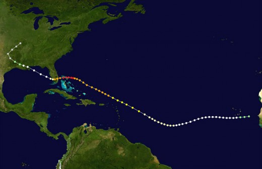
The 1947 Fort Lauderdale Hurricane track began on September 2nd, when an area of low air pressure resulting from a tropical wave was detected over French West Africa. Two days later, the system quickly developed into a tropical storm, although the cyclone was not detected until September 10th
On the 5th, the storm quickly gained strength and became a hurricane, moving westward at about 17 miles per hour. On the 7th, the storm turned southwest, on the 9th, became a category 2 hurricane.
According to the National Hurricane Center, the 1947 Fort Lauderdale Hurricane reached maximum intensity of 160 mph winds just 95 miles east of Hope Town on the Abaco Islands. The storm then crossed through the northern portions of the Abac Islands, and onto the Gulf Stream, losing some strength.
The 1947 Fort Lauderdale Hurricane finally made landfall near Fort Lauderdale, Florida, on September 17th at the strength of category 4, with peak gusts of 155 mph and sustained 122 mph winds hitting Hillsboro Inlet Light near Pompano Beach. This reading would remain the highest measured wind speed in the state of Florida until Hurricane Andrew some years later.
On the 18th, the hurricane’s sustained winds lost strength, diminishing to 90 mph as the storm turned west-northwest at 15 mph. On the 19th, the storm moved over the shore of Saint Bernard Parish, Louisiana as a major hurricane, weakening as it moved through New Orleans, and weakening further as it moved through central Louisiana and Baton Rouge, becoming a tropical depression over the north eastern parts of Texas, and finally, dissolving over southern Missouri after one more pass through Oklahoma and Arkansas.
1947 Fort Lauderdale Hurricane Tracking
Hurricane Damage for The 1947 Fort Lauderdale Hurricane
Damages and deaths through the Bahamas remain unrecorded, although it is known that Green Turtle Cay suffered flooding with two feet of water, and many homes were damaged or destroyed in Grand Bahama, while all docks received some minor or major degree of hurricane damages.
In Florida, an eleven foot storm surge was reported along the coast as the hurricane first made landfall, and large stretches of State Highway A1A were washed out by the waves. The Boca Raton Army Air Field (today known as the Boca Raton Airport) suffered heavy hurricane damages, reportedly totalling three million dollars in costs to repair.
Similar storm surges were reported at Lake Okeechobee, with a twenty foot surge being reported along the southern shores between the cities of Clewiston and Moore Haven, almost overrunning the Herbert Hoover Dike surrounding the lake.>
In total, seventeen lives were lost in Florida, and total hurricane damages to crops in the Fort Pierce area were estimated at four million US dollars.
In total, at least fifty one lives were lost as a direct result of the hurricane, and more than one hundred ten million in damages were dealt. Adjusting for inflation, the number would be closer to one billion dollars in the 2009 economy.

How The 1947 Fort Lauderdale Hurricane Compares to Other Hurricanes
The 1947 Fort Lauderdale Hurricane is most easily compared to the Okeechobee Hurricane of 1928, which struck roughly the same areas. In 1928, the Herbert Hoover Dike actually collapsed, leading to much greater damages. This time, the dike held, preventing the storm from doing as much hurricane damage as it potentially could have.
Nonetheless, the dike was strengthened some time after the Fort Lauderdale Hurricane in order to make certain that it would hold through the next storm, as well.
The 1947 Fort Lauderdale Hurricane Aftermath and Hurricane Recovery
The 1947 Fort Lauderdale Hurricane came very shortly after the end of World War II, and just before the start of the Cold War, and had struck an area recently hit by stronger hurricanes. As a result, the hurricane was largely forgotten in the media and the public eye. Building codes and hurricane preparation had both come a long way since the more destructive hurricanes of the 1920’s, and, thankfully, the damage done was able to be contained.
We include The 1947 Fort Lauderdale Hurricane on this list as an example of the fact that hurricane preparation has to take place on a broad scale. Hurricane preparedness is not just boarding up with hurricane windows and hurricane shutters, but tracking hurricanes on a worldwide level and issue hurricane news to all residents of areas that are to be struck, as well as putting further hurricane protection measures into place, such as planned evacuations and so forth.
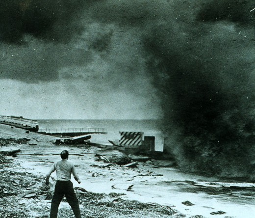
Coconut Palms and power poles topple before the intense winds of the 1947 Fort Lauderdale Hurricane. September 17, 1947
 2009 MICHAEL LACA - Tropmet.com")
Other hubs on hurricanes (Not part of the World's Worst Hurricanes series)
- Hurricane Season
Hurricane season begins on June 1 and runs through November 30. Living in Louisiana, preparing for hurricane season every year is a way of life. And, for those of us that got lax, Hurricane Katrina... - Hurricane Supply Checklist
So you've done everything you could to protect your home and windows during a hurricane. Now you should focus on hurricane supplies. Most experts suggest you have anywhere from three to seven days worth... - Video: Hurricanes, Cyclones and Typhoons
Hurricanes, cyclones and typhoons will in best of situations pick on thousands of the best fish in the oceans and feed the masses of people inland. Hurricanes, cyclones and typhoons are always shy of the... - Hurricane Preparedness Supplies for Your Pantry
Concerned about getting ready before a hurricane threatens or strikes your area? While there are many things that you need to do to secure your home, it's also essential to make sure that you have a... - How Hurricanes Get Their Names
As I write this, I am barely able to contain my excitement. After six long years of waiting, finally I will get my opportunity to take the world by storm...literally. If not this year, than in 2014 for... - Galveston Oh Galveston! The Hurricane Ike Cover-Up
As an avid follower of world events and hurricanes the last few years, I watched and followed Hurricane Ike very closely these last couple weeks. I followed Hurricane Ike as it formed in the Atlantic,... - Hurricane Shutters:Which are Right for You?
Hurricane shutters protect your windows by shutting out debris. They also help to stabilize and protect your entire home during a hurricane. The shutters will help to keep water and high winds from damaging... - Hurricane Preparedness--Protect your windows
You need to protect your windows during a hurricane for a couple of reasons. The first and most obvious is rain can get into your house through a broken window. Wind and debris can also make their way...
This hub brought to you...
by Julie-Ann Amos, professional writer, and owner of international writing agency www.ExquisiteWriting.com
Why not create your own HubPages? It's fun and you can make revenue from Adsense and other revenue streams on your pages. JOIN HUBPAGES NOW - SIMPLY CLICK HERE... (or contact me to write one for you!)
This work is licensed under the Creative Commons Attribution-Non-Commercial-No Derivative Works 3.0 Unported License. To view a copy of this licence, visit http://creativecommons.org/licenses/by-nc-nd/3.0/ or send a letter to CreativeCommons, 171 Second Street, Suite 300, San Francisco, California94105, USA.