How to Protect Yourself from a Flood Disaster – Part I: Choosing a Place to Live
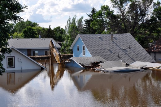
Flooding is the most common natural disaster in America today. In fact, in 2010 alone, there were 54 presidentially declared disasters that involved flooding. This was higher than any other category of disaster for that year. 2011 isn’t looking any better either; at halfway through the year, there have already been 47 presidentially declared disasters related to flooding. It must be noted though that there are certain minimum thresholds that must be met for the president to declare a situation a disaster. There were literally 100’s of flood related incidents in 2010 and 2011 that did not meet these minimum thresholds.
Flooding is so widespread and it’s getting worse. Knowing how to protect yourself from it is more important now than ever before. One of the best ways to prevent becoming a victim of flooding is to ensure that the property you are about to purchase is not in a floodplain or a flood prone area. In no particular order, here are 5 tips to help you locate a property that is reasonably safe from flooding.
Tip#1 – Utilize FEMA’s Flood Insurance Rate Maps
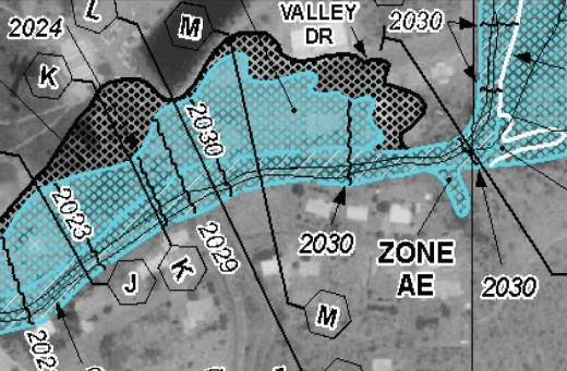
FEMA’s Flood Insurance Rate Maps or FIRMs (sometimes referred to as “flood maps”), are maps produced to show areas of the country that are subject to a 1% annual chance flood (100-year flood). The two main purposes of these maps are to show areas where the purchase of flood insurance is mandatory (for mortgage holders) and where strict building regulations exist. However, do not rely solely on these maps for a property buying decision. Not every area that has or will flood is shown on the maps, nor do they take into account localized flooding problems. Floods that are more or less likely to occur in any given year may not be adequately represented on these maps either.
To view a copy of these maps, check with your local City or County government. If your community participates in the national flood insurance program (NFIP) then the community must have the maps available for the public. You can also view the official maps on FEMA’s website here: http://www.msc.fema.gov Your local county or city government may also have this mapping available on their website.
FEMA also has a Map Viewer Tool that allows you to zoom in to a particular address: https://hazards.fema.gov/wps/portal/mapviewer
And finally, if you have Google Earth, you can download the National Flood Hazard Layer Here: https://hazards.fema.gov/femaportal/wps/portal/NFHLWMSkmzdownload
Tip#2 – Check out Available Topographic Maps of the Area
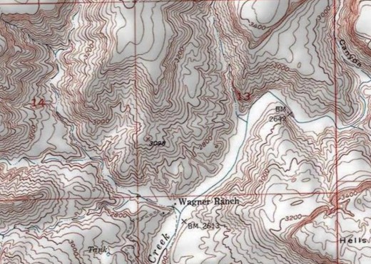
If you can visualize the topographic features of the ground in and around the property you want to buy, you can get an idea of the potential for flooding at that site. Generally speaking, the larger that an area is that drains toward a particular property, the larger the risk and potential for flooding there is.
These maps can also give you a good idea of the slope or “steepness” of the land upstream of the property. This is important for two reasons: 1) The steeper the slope is the faster the water will flow, and 2) steep slopes tend to slow down the natural infiltration process of water. In addition to slopes and grades, topographic maps can be used to easily identify rivers, streams, washes, and arroyos. You can follow the stream upward above the property of interest and assess how long it is. Generally speaking, the longer that a stream is upward of a property, the greater the flood potential it has.
Many decent topographic maps should be available at your local jurisdiction's engineering office for a nominal fee. Free maps do exist, but they aren’t as accurate or as new as the ones your City or County map have. Usually though, the free ones that are available will give you enough information to help you with your purchasing decision. The USGS topographic maps can be viewed for free at several locations on the Internet. Check out the following great resources:
ESRI’s Online GIS Map Viewer http://www.arcgis.com/home/webmap/viewer.html
Microsoft Research Maps http://msrmaps.com/
The National Map Viewer http://viewer.nationalmap.gov/viewer/
Tip#3 – Ask Your Local Jurisdiction for Information about Flooding
The people with the best knowledge of flooding in an area will likely be the local jurisdiction that governs it. These are the people who review drainage plans for developments, perform flood mitigation studies, operate gauging stations, respond to emergencies and disasters, and monitor road hazards. Don’t be afraid to ask the field and maintenance workers about their knowledge of an area. They should have a good working knowledge about an area’s flooding history because they are the ones that are called to duty when a flood happens.
Many government entities also keep records of engineering studies and reports that you can use to assess the flooding conditions of a site that you are interested in. You may also be able to obtain road closure and maintenance records from them as well. Some jurisdictions have Area Drainage Master Plans (ADMPs), Watercourse/Watershed Master Plans (WMPs), or Stormwater Drainage Master Plans (SDMPs) that are used to identify flood problem areas (among other things). Don’t forget to take some time to explore the governing body’s website. These sorts of plans are usually available for public viewing at no cost to you.
Tip#4 – Seek the Services of a Professional Engineer
When in doubt, seek the advice of a professional. When looking for a consultant to advise you on the build-ability or flood risk of a property, be sure to find one the works in or near the area that you are interested in. Check their credentials and make sure that they have plenty of experience in the areas of drainage, hydrology, hydraulics, and floodplain studies. Don’t be afraid to ask to see previous projects that they have worked on to help you assess their level of knowledge on the subject.
The engineer can research a property’s flood history (using some of the techniques I have presented above) and perform a scientific investigation into its future flood potential. They will review things such as, soil conditions, weather patterns and statistics, natural topography, vegetative cover, and manmade changes to the land in an effort to get a detailed and complete assessment of the conditions at the site. If the land is vacant, you may be required to consult an engineer anyway to build on it. Engineers’ will charge a fee for this service, but the knowledge and peace of mind gained is invaluable.
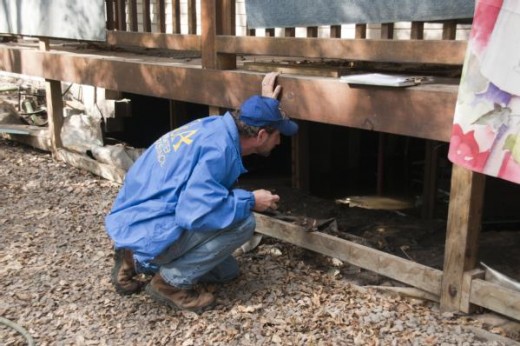
Tip#5 – Inspect the Property before Purchasing It
Finally we come to my last tip. This one should really go with out saying, but never buy a piece of property without first inspecting it yourself. If there is a building on the land, have it professionally inspected for structural defects and evidence of prior flooding. If you really want to be sure, have the air inside the home checked for abnormal levels of mold spores.
When it comes to the structure itself, you will want to check that the floor elevation is at least 6 inches above the adjacent ground elevations to the home. Next, check the grading around the home. It needs to slope away from the structure to prevent water from ponding up against the foundation. If frequent ponding has occurred, there will be subtle indications of it such as brittle and crumbling concrete.
When at the site, take a look at the entire property and look for evidence of previous flooding. Search for peculiar sand and silt deposits as well as debris and mud lines in the vegetation. Check the wood on the out buildings and porch columns for evidence of warping, peeling, splitting, or rotting. These are good indications that the wood may get wet frequently.
In addition this, make sure you inspect the neighborhood itself. Drive around and look for evidence of flooding. Some revealing signs of a flood problem include such things as elevated driveways and homes, earthen berms around the property, and sand on the roads. And lastly, ask your future potential neighbors if they have ever had any problems with flooding in the area.
Conclusion
After utilizing these tips, I expect that you will be able to find a new home or property that is reasonably safe from flooding. I hope that have empowered you with some resources to help make your next property purchase an informed one. In the end, you will have peace of mind knowing that you and your family is reasonably safe from flooding. You can also relax and enjoy the rain the next time a storm rolls in.


