- HubPages»
- Travel and Places»
- Visiting Africa»
- Travel to Southern Africa
A cigarette-card tour of South Africa


Cigarette cards
From around 1875 tobacco companies in the United States began to issue cards with pictures on them, usually depicting beauties of the stage and (later) screen, cultural effects, and sports people. Companies in other countries followed suit soon after, with John Player in the United Kingdom being a prime mover in this regard.
In South Africa too tobacco companies issued cards, often with historical or scenic themes. In this Hub we take a tour of South Africa guided by a selection of one set of such cards.
In 1938 the United Tobacco Company (UTC) issued a set of 100 cards illustrated by South African artist Charles Ernest Peers (1875 - 1944) showing typical scenes from the four provinces of South Africa, as well as some from South West Africa (now Namibia), Lesotho, Zimbabwe and Swaziland.
These cards were issued under the title Our Land - Ons Land and an album was printed in which to paste the cards. The book was printed by Messrs Galvin and Sales in Cape Town.
I am lucky enough to have a copy of this book in fairly good condition into which my mother, I think, pasted the cards. Of the 100 cards in the series 99 are in the album. If it was my mother who pasted in the cards she must have gotten them from other people, as neither she nor my father smoked.
What follows is a selection of the cards.


The book
The book is a very handsome one with 34 beautifully-designed pages and four large reproductions of paintings by Peers.
The colour plates illustrate Namaqualand flowers, the Cape Dutch homestead "Morgenster (Morning Star)" in the Western Cape town of Somerset West, flower sellers on the Grand Parade in Cape Town, and a rather fanciful illustration of animals at a stream in the Kruger National Park.
The arrangement of the cards in the book is not altogether logical, jumping from one province to another and back again. They can be arranged, as I have done here, to illustrate a trip around the country from Cape Town and the Western Cape, through the Eastern Cape, kwaZulu-Natal, the Transvaal (now broken into three provinces: Mpumalanga, Gauteng and Limpopo), the Free State and the Northern Cape (then still part of the Cape Province).
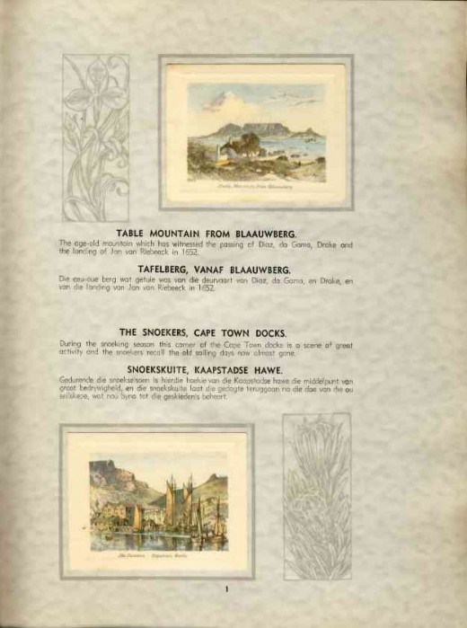
Page one of the book is beautifully decorated with drawings of a Disa and a Protea and has cards of a view of Table Mountain from Blaauberg Strand and the snoek fishing boats in Cape Town harbour.


The Western Cape pictures
The book has far more pictures of scenes in the Western Cape than any other region of the country.
I have reproduced the titles and captions of the cards exactly as they appear in the book.
Snoek is a species of fish looking a little like barracuda. Its scientific name is Thyrsites atun and it is a very important part of the economy of the Western Cape, and has been for centuries. A feature of life in Cape Town until the late 20th Century was the "fish horn" made of kelp and sounded by peddlers selling fresh snoek from their horse-drawn carts.
The Castle of Good Hope was started by the Dutch East India Company in 1666 and completed in 1679 and is the oldest building in South Africa. It is in the shape of a five pointed star, each of the points or bastions having a name: Leerdam, Buuren, Catzenellenbogen, Nassau and Oranje.


The Eastern Cape pictures.
From the picturesque Western Cape we travel to the Eastern Cape where the settlers of the eastward expanding colony met the Nguni peoples who were expanding their territory westward.
Part of the British colonial policy was to stem the advance of the Xhosa people by settling English settlers in the frontier areas. Around 4000 British settlers arrived in the area which became known as "Albany" in 1820. Grahamstown was the centre of Albany.
The "Old Provost" in Grahamstown was built as a prison in 1838 by the Royal Engineers. It was part of a fortified barracks and was built on the then-popular "panopticon" plan for such buildings. It was declared a National Monument in 1937.


The Natal pictures
Natal was so named by Portuguese explorer Vasco da Gama when he arrived on the shores of the region in December 1497. It is a warm, sub-tropical area which features lush vegetation and is particularly well suited to sugar cane growing.
The Valley of a Thousand Hills is a spectacular sight between the large port city of Durban and the Province's capital, Pietermaritzburg. The famous annual ultra-marathon road race the Comrades Marathon is run between these two cities and the route skirts around the Valley.


The Transvaal pictures
After the lush green valleys oif Natal out tour crosses the escarpment and comes to the rarified air of the Highveld, with its crisp, dry, cold winters and hot wet summers of thunderstorms alternating with a searing sun beaming down from deep azure skies.
Here too the different peoples that have come to make up the South Africa of today had their clashes over land ownership, land use, and the franchise.
It is a countryside that in the 19th Century was criss-crossed by the long ox wagon trains of the "transportryers (transport riders)" carrying supplies from the coast to the burgeoning highveld gold mining towns, and taking the produce of the farms and mines to the coast for export.


The Free State, Kimberley and the Aughrabies Falls
I have lumped all these cards together although they would take up a few days in time.
"Long Cecil" was a gun built during the siege of Kimberley. It was designed by a US citizen in Kimberley at the time (December 1899) George Labram and fired its first shot on 19 January 1900. The gun now stands on the stylobate of the Honoured Dead Memorial in Kimberley.
The Honoured Dead Memorial was designed by famed architect Sir Herbert Baker on commission from Cecil John Rhodes to commemorate those who died in the siege. It has an inscription penned by Rudyard Kipling, also commissioned by Rhodes:
THIS FOR A CHARGE TO OUR CHILDREN IN SIGN OF THE PRICE WE PAID
THE PRICE WE PAID FOR THE FREEDOM THAT COMES UNSOILED TO YOUR HAND
READ REVERE AND UNCOVER FOR HERE ARE THE VICTORS LAID
THEY THAT DIED FOR THE CITY BEING SONS OF THE LAND


The Colour Plates
The four colour plates illustrate various aspects of South Africa - the flowers of Namaqualand, which are an annual display of nature's incredible bounty and beauty; flowers being sold by the traditional flower sellers of Cape Town, who have plied their trade there for centuries; the magnificent gabled beauty of Cape Dutch architecture as epitomised by the homestead "Morgenster (Morning Star)" on the original "Vergelegen (Far-off place)" wine estate; and, finally, the somewhat fanciful view of game in the Kruger National Park.
Cape Durch architecture is an indigenous architecture with definite Dutch influence, especially in its most characteristic feature, the beautiful, elegant rounded gables. The houses were most commonly in H shape and the gables were almost always highly decorated with ornate yet elegant plaster work.
Namaqualand is a semi-desert region inland from the west coast north of Cape Town. In spring each year, anytime from July to September, depending on when the rains come, the desert is transformed with dense carpets of brightly coloured flowers.
Copyright Notice
The text and all images on this page, unless otherwise indicated, are by Tony McGregor who hereby asserts his copyright on the material. Should you wish to use any of the text or images feel free to do so with proper attribution and, if possible, a link back to this page. Thank you.
© Tony McGregor 2010


 - The Khoi People")


