- HubPages»
- Travel and Places»
- Visiting Africa»
- Travel to Southern Africa
Exploring the Drakensberg Ranges

Drakensberg Ranges, South Africa


About the Drakensberg Ranges
A UNESCO World Heritage site containing pristine national parks, waterfalls, ancient rock art and unique ecosystems, the uKhahlamba/Drakensberg mountains are quite simply a delight. This main range of southern Africa rises to more than 3,475 metres (11,400 feet) and extends roughly north-east to south-west for 1,125 km (700 miles), forming a border between South Africa and the Kingdom of Lesotho.
The range’s sandstone base has been eroded over time to form caves and overhangs, while its basalt peaks and buttresses are dramatic backdrops to its lovely grasslands and woodlands.
There is something for everyone here:
- easy trails for those wanting an easy 20-minute meander
- hikes for trekkers who desire the challenge of multi-day calf-stretching walks
- lakes for fishing
- horse-riding
- tons of photography opportunities (the sunrises are sensational!)
- a plethora of flora for the botanist.
But wait, there's more...
- Adrenalin junkies will get a kick out of abseiling down or scaling the sheer mountain walls.
- Wildlife-lovers will enjoy the birds, animals, butterflies and reptiles that grace this area.
- Art and history buffs can check out the many rock shelters containing San/Bushmen paintings created over a period of at least 4,000 years and depicting subjects such as eland, people and figures with human and animal characteristics.
- Those wanting rest and respite can go on scenic drives, swim in natural or resort pools, or even try a spot of wine tasting.
uKhahlamba is the Zulu word and Drakensberg the Afrikaans word for the Dragon Mountains.
Come with us on our journey through this remarkable region.
Something for lovers of our feathered friends


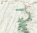
Location and access
The Drakensberg Ranges stretch the length of the border with Lesotho, between Johannesburg and Durban.
The Royal Natal National Park, marked 'A' on the map, is a feature of the Northern Drakensberg Ranges and lies about 337 kms or 31/2 hours' drive from Johannesburg. You might want to stop off in Harrismith, a pleasant little town, for lunch, as we did.
The Southern Drakensburg Ranges, with the Sani Pass marked 'B' on the map, are nearer Durban (250 kms or 2-3 hours' drive away).
You can drive from the northern to the southern ranges in a day, passing through some amazing scenery and stopping off in interesting towns with tourist sites such as waterfalls, woodlands and caves. The distance from Royal Natal National Park to Sani Pass is 335 kms or about 41/2 hours' drive.


Useful information
Temperature
Plunging from 3,000-metre high peaks often covered in snow to river valleys with rolling hills, the ranges have a wide range of temperatures, the average being a high of around 30 degrees centigrade (86 degrees fahrenheit) in summer and a low of 12 degrees centigrade (53.6 degrees fahrenheit) or lower in winter.
Accommodation
Like the rest of South Africa, the Drakensberg Ranges offer accommodation for all budgets, from campsites and backpackers' accommodation to self-contained chalets and cabins, and luxury lodges and resorts. Due to their location in areas quite some way from towns, many of these places offer half board (dinner, bed and breakfast) and activities such as guided walks or horse-riding. Consult tripadvisor and booking.com for advice and deals.


Northen Drakensbergs
The northern part of the Dragon Mountains has waterfalls, craggy peaks, woodlands and river valleys. It is a beautiful area for walking and horse-riding. Royal Natal National Park (see below) contains a network of both short and long hiking trails, and is easily accessed from Bergville, one of the major towns in this region.
Waterfalls, woodlands and wonderful wildlife


Royal Natal National Park and Tugela Gorge
About Royal Natal National Park
Royal Natal National Park contains the Amphitheatre, a sheer rock wall 5 km (3 miles) long and up to 1,200 metres (3,900 feet) high. down which the Tugela Waterfall cascades for 948 metres (3,110 feet).
The intrepid can traverse heathland beneath the ranges, climb up the Amphitheatre on 50-rung chain ladders and walk to the edge of a cliff for stunning views, on an all-day walk from Sentinel car park or even on a two-day hike from Mahai River Campsite.
Rock art enthusiasts can go on an easy 6-kilometre walk from the park's visitor centre, along Tugela River to Sigubudu Valley where there are ancient San paintings of eland, people and hand prints. National park staff can recommend trained local people who will act as guides, explain the origin of the paintings and point out fossils.
The Royal Natal National Park homepage has information on the rock art walk and other hiking trails, as well as useful information on access.
About Tugela Gorge
We did the lovely 16-kilometre (10-mile) return walk to Tugela Gorge that starts in Thendele car park, and ascends and descends through protea veld peppered with wildflowers and covered with butterflies, and woodlands with stands of yellowwood that ring with birdsong and are verdant with mosses.
The gorge is amazing with green streams and pools, wave-shaped walls and greenery.
Once there, you can climb a chain ladder and walk for a further half-hour or so for fab views of Tugela Falls and the Amphitheatre, or, when the water level is low, boulder hop through the gorge and explore its magnificent terrain.
Birds, butterflies and breathtaking beauty

Southern Drakensberg Ranges
The dramatic Southern Ranges contain sheer slopes plunging down to pebbly streams and pretty villages with manor-style accommodation. This region is home to the Sani Pass, the only 4WD track into Lesotho from the Drakensberg region up an unsealed and ridiculously steep road that zig zags for 21 kms from the start of the gravel track to the Lesotho border.
The region has many superlative walking tracks, including the epic 5-day Giant's Cup Hiking Trail from Sani Pass to Bushmens Neck.
From Kamberg, you can take a return guided hike of about 3 hours' duration to Game Pass Shelter, where there are some fantastic examples of ancient San rock art.


Driving up the Sani Pass
The Sani Pass is infamous for having one of the steepest ascents on one of the worst roads in the world. The pass starts at 1,544 metres (5065 feet) and rises 1,332 vertical metres (4370 feet) to the summit at 2,876 metres (9435 feet) where the border with Lesotho is based. Here you can also stay or have a well-earned drink at Sani Mountains Lodge .
In the late afternoon of a beautiful day, we drove up the pass in our hired 4WD vehicle. The road surface passed abruptly from sealed to gravel with potholes, shale and cracks. We jolted for about 20 minutes through a pretty valley with a river to the South African border 15 kms away. Relaxed gentlemen inspected our passports and stamped us out of the country.
We were now in no-man's land, in more ways than one, having to travel on a road in appalling condition with massive holes and a smashed-up surface to the Lesotho border 6 kms away. Crags rose to dizzying heights above us, threatening to shower us with rocks, while waterfalls splashed on the roof of the car and chacma baboons strolled nonchalantly past. There was no barrier between the edge of the, at times, one-way track and the long drop to the valley beneath.
The only traffic was the occasional local truck driven by a grim-faced individual trying not to skid or roll and a smattering of tour buses.
Certain sections are as steep as 1:4 and it is here where our wheels span and we thought we would not make it. But we did.
I was happy to reach the Lesotho border, even though the 'highest pub in the world' was closed. We turned round and came back, stopping off at various pull-off points to admire the spectacular scenery. We were held up for a while by a local bus that had broken down in the middle of the road.
It was an exciting, adrenalin-fuelled experience, but it was good being safely back in the hotel nursing a stiff drink.