Mexaltitlan: Lost City of the Aztecs?

Some Views of "Mexico's Venice"
Click thumbnail to view full-size


Life Inside a Goldfish Bowl
Mexaltitlan: Lost City of the Aztecs?
This island village must be one of the most singular places in the world, certainly in the Americas. Few people have been there, although thousands zoom by a few short miles away on the highway from Mazatlan to Guadalajara. In fact, Mexaltitlan is not mentioned on most maps and, although close to civilization, is rather inaccessible half of the year.
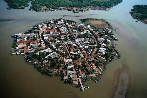
Mexaltitlan lies on - or rather is - an island on the River San Pedro, where it is embroiled in a constant struggle to keep its head above the silt-filled water.
There is some evidence to back up the belief that this waterlogged isle contains the long lost city of the Aztecs, Aztlan, (place of herons), which the warrior race was said to have abandoned in 1111 to resume their journey for their promised kingdom. There are many similarities in Aztec lore, preserved by Cortez, and now found in crumbling tomes preserved in Spain, and the geography of the village as seen and situated today, especially the circular canal system. The township such as it is, laid-out in sections representing the four cardinal points of the compass: this has similarities to the pattern of Tenochtitlan, as designed by Moctezuma, the great pre-Hispanic, Golden City of the Aztec in the Valley of Mexico.
Historians also postulate that the Aztecs were the last Indian race to head south away from the North American land mass into Mexico. Surely, they say, they would have taken the Pacific route, on the coastal plain to the west of the Sierra Nevada and close to fresh water and fishing, etc., rather than try to survive in the rugged mountains or face the conditions of the Sonora Desert inland. When they arrived at what was to become the Place of Herons, they would have also welcomed the security provided by the island location as well as the opportunities for continued fishing and the Aztec practice of constructing floating gardens from reeds and soil for vegetable production. (As seen today at the Floating Gardens of Zochimilco in Mexico City).
The island does seem to float when seen from the air and looks all the world as if some intergalactic space-station has landed close to the mountains and jungles of Nayarit State. It sits in one of the largest estuaries in the Americas, a watery-wonderland and wild-life sanctuary that becomes a mammoth swamp in the dry season.
This sweet, mineral-rich lagoon, teems with fish and shrimp, as well as edible game birds, from all of which the men folk of the village eke-out a tenuous living. Until a few years ago when the government intervened, mortality rate was very high. Things are better today, but not by a wide margin. The main problem is one shared by all of us, overcrowding, as nearly 5,000 people are stacked on this tiny platform. This means that most of the young up and leave, finding work in nearby Tepic, or heading further afield to Guadalajara or even Mexico City, increasing the almost intolerable pressure there.
Traditionally, marriage has never been a problem in Mexaltitlan; few can afford wedding nuptials, so common law arrangements are de rigeur. The leading malaise in the place is boredom: there is little entertainment: one cine and the usual cacophony from TV’s that don’t need an off switch…and a stately church with a cracked bell! The goldfish-bowl ambience of the island can be claustrophobic. Take a healthy stroll around the circumference and you will return to your starting place in minutes. You hear a Looney Tune singing, “That’s all, folks!”
Mexaltitlan means first and foremost, boats and boating. Every family owns at least one sturdy craft topped by a powerful Japanese outboard motor. Rentals are also easy to find. Boats are used mainly for work; even if residents do take the 2-mile trip to the mainland, there is little to do when they arrive. The place is undoubtedly lovely in the wet season with the hundreds of square miles of water lilies filling your senses. Breathtaking as this vision is to the casual visitor, the snake-like tubers of these plants are the bane of the islander’s existence, as they choke waterways, wind round boat propellers and make fishing, especially shrimp netting, impossible. Anyone who has water lilies in the garden pond knows how hard they are to control. Imagine 1000 square miles of them!
The men fish from May to October during the monsoon season. After that, they must seek work on the mainland as the waters recede leaving an ever-widening circle of inaccessible swampland. Some find work in Nayarit, one of the least explored areas in the world where jaguars roam the mountains and wild boar snuffle through the lower jungle. This season is, however, the best time to visit this really quite delightful and unique spot, as the tropical downpour makes all impossible in the wet months.
The best way to get there is by car or bus from Tepic, taking the left turn as you head north just past the Rio (River) Chilpa. Tepic has good motels and a tiny airport, otherwise, it’s a dull, sugar town and unbearably hot most of the year.
Puerto Vallarta is 100 miles south of Tepic on the same highway.


")
