O, Canada - Beautiful British Columbia


Touted as "God's Playground" by its residents, British Columbia is home to some of the most spectacular scenery in all of Canada...just ask the people who live here!
British Columbia has long been divided by regions, as are several of our provinces, however few are as diverse and rugged as B.C. Whenever a long time resident is asked where it is they call home, most of them answer by region as a guide to the specific location.
If they live in Kamloops, or Osoyoos, they might tell you they live in the Interior, or Thompson Okanagan. Someone from Prince Rupert or Fort St. John,would say Northern B.C. People who live in Victoria, or Nanaimo, will tell you they live 'on the Island'. Residents of Gibson's or Garibaldi, might answer the Gulf Islands, whereas an Abbotsford or Chilliwack native would say the lower Mainland, or Fraser Valley. Are you confused yet?
The only place that doesn't need an explanation or guide book to find it is Vancouver. Anyone who watched the 2010 Winter Games knows where Vancouver is!


Welcome to my home
Having lived most of my life in B.C. I have seen my share of its mountains and rainforest.
This province boasts a total of 15 mountain ranges interspersed with plateaus, highlands, lowlands, and plains.
Our rugged coastline extends over 27,000 kilometers (17,000 miles) and includes deep, mountain fjords and approximately 6000 islands. Most of the west coast is covered in temperate rain forest, one of a mere handful of temperate rainforest ecosystems in the world.
B.C. also contains seven of Canada's thirty six National Parks, 141 ecological reserves, a large network of provincial parks, and has 114,000 kilometers (44,000 sq. miles) of protected land. B.C.'s provincial park system is the second largest in Canada, the largest being Canada's National park system.
As well the province has 47,000 kilometers (18,000 sq. miles) of arable, (farm,) land, protected by the Agricultural Land Reserve.
To give you an idea what these figures translate to land mass-wise, 75% of the province is mountainous, 60% is forested, and only 5% is arable.
Welcome to my home.
Northern B.C.
Northern British Columbia can be separated into two distinct areas, the North West Coast, and the Northern Interior. The North West Coast's mountains and the Inside Passage's many inlets provide some of British Columbia's most renowned and spectacular scenery. Flanking the fjords are mountains that rise thousands of feet from the sea shore; many of these mountain sides are near vertical, and extensive mountain glaciers cover the higher elevations of the mainland ranges.
British Columbia shares similarities with Labrador, in as much as the coastline landscape is rugged, uncompromising and at times very unforgiving.
Haida Gwaii - the Queen Charlotte Islands
The first, and possibly one of the most memorable, places I called home in British Columbia was on the Queen Charlotte Islands, now a National Park Reserve and Haida Heritage Site. This archipelago of 138 islands, the largest of this chain being Graham Island, home of Haida, (once called Old Massett,), Masset, (where we lived,) and Moresby Island, which houses the only airport in Sandspit, sits 130 kilometers off the north coast of British Columbia.
An estimated 750,000 seabirds such as the rhinoceros auklet, ancient murrelet and tufted puffin nest along the shoreline of the National Park Reserve (Gwaii Haanas,) from May through August. Bald eagles are a common sight, and hundreds nest along the island coastline.


Northern Interior
This area of B.C. is home to several National Parks, and is virtually unsettled. The farthest northern interior settlement is Fort St. John, with the northern most point on the coast being Prince Rupert. Please don't misinterpret 'settlement' to indicate covered wagons and pioneers. Yes, you could class some of the residents as descendants of pioneers, but now these cities and towns all boast cell phones, internet and the latest technologies.
The Interior Plains dominate B.C.'s
north east corner. Known as the Peace River District, this is an extension
of the prairie lands that make up Alberta and much of southern Saskatchewan
and Manitoba. The gently rolling landscape is perfect for agriculture and ranching.


Gulf Islands
An extension of B.C.'s coastline, the Gulf Islands are one of the most popular holiday resort and self-proclaimed artist havens. From hand dipped candles, stained glass, or Island-made goat cheese, you can find a wealth of home-spun arts in many of the small communities that dot these islands.
Welcome to the Capital
Our capital city, Victoria, sits on the southeastern tip of Vancouver Island. Getting around this city is as simple as waving your hand. Here you can experience horse-drawn carriages, double-decker buses, inner harbour ferries, and even kabuki cabs. Tourist attractions abound in Victoria, and include whale watching tours, fishing excursions and the world famous Butchart Gardens.


Lower Mainland
This is the place I call home. The Lower Mainland, or Fraser Valley to some, depending on which part you hang your hat.
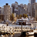
Vancouver, the jewel of the region, is the largest city in the province, the eighth largest city in Canada, and is world renowned since hosting the 2010 Olympic Winter Games in February.
This amazing region boasts white sandy beaches, rain-forest nature trails, world class ski resorts, shop till you drop shopping centers, and some of the valley's best agricultural land.
Abbotsford is very proud to be not only known as the berry capital of the world, but also the home of the famous Abbotsford International Airshow.


Cariboo - Chilcoten
This area is mostly comprised of cities and towns like Bella Coola, Williams Lake, Barkerville, Lillooett and Quesnel, to name a few. What makes this area so different is the direct route from the coastal city of Bella Coola to Williams Lake.
This region was born when the discovery of 'gold in them thar hills' spawned the Cariboo Gold Rush. In 1852, a prospector named Billy Barker found gold at Williams Creek, and the subsequent influx of miners and supplies demanded the building of a permanent residence. In its hayday, Barkerville was the largest city west of Chicago, and north of San Francisco. Today, over 125 Heritage buildings have been restored and are open for visitors to wander through and dream of a time 130 years ago, when the 'west was young'.


Thompson Okanagan
This is the heart of British Columbia, just don't let the west coaster's hear me saying that.
Not only is this area perfect for ranching, the climate varies from temperate to arid in a very short distance. This region is home to desert, lakes, mountains and rich farm land.
Okanagan Lake is one of the most popular lakes in the area, along with the Shushwap, and is rumored to be the home of Ogopogo, Canada's version of the Loch Ness Monster.
This region is also world renowned for white water rafting, in particular the Fraser Canyon and the Thompson River. Some of the best white water is right in our own back yard!


B.C. Rockies
Last, but certainly not least, we come to the area that above all, is famous for its breathtaking heights, views and parks.
The Rockies.
This region is home to natural hot springs, parks, challenging, (to say the least,) golf courses, and an intriguing heritage.