- HubPages»
- Travel and Places»
- Visiting North America»
- United States
Photo Shoot Dante's View to the Death Valley Salt Flats

Road Trip Viewing of Death Valley California


A 12 Hour Road Trip Tour California Badlands
The day started early as we headed out of Las Vegas toward Pahrump Nevada. We had made a plan to stop at the Terrible's Town Casino in Pahrump for breakfast before buzzing our way across the desert and into the California mountains. The food at Terrible's Town Buffet was awesome and very reasonable. Started the morning off with a grand portion of chicken fried steak and eggs, hash brown potatoes and wheat toast. 12 hour road trips require hearty eating.
We left Henderson Nevada at 7:00 AM on Saturday morning. I did not make any of the plans for this day trip. My sister was the one who took all the necessary information and managed our day. I was along for the ride and the story. I made sure to charge my camera the night before and I put on my hiking shoes.
I was intent on shooting plenty of photos for my work. I knew the photos would come in handy later. I also wanted to share them with everyone. I like to use the photographs for reference. It is amazing how the images can bring back vivid recall. This helps with my artwork using colors, textures and lines.
Destination Dante's View Death Valley National Park
Our first encounter with the vast, desert, horizon ahead was going to be Dante's View. Dante's View is a viewpoint terrace at 5,475 feet (1,669 meters) height, on the north side of Coffin Peak. It runs along the crest of the Black Mountains overlooking Death Valley.
There is no way I was mentally prepared to imagine what I was about to see. The scope and magnitude of Death Valley California is beyond the imagination until it has been experienced. I am sure my little camera did not capture the depth of beauty and majesty I physically felt as my mind tried to wrap around this marvel. This place has a way of putting much of life into a most certain perspective.

Taking in Dante's View

Hikng Up
The path did not appear to be anything to think about. I wanted to get up as high as possible to shoot what I felt might be better photos. Hiking across the rocky path my spirit was absorbed in my surroundings. Not until we headed back toward the car did my legs start to ache and my lungs start to burn in the thin air on that steep grade.
I would not have missed it for the world. The view was outstanding. This had to be one of the most magnificent and powerful places I have ever seen. Death Valley, by it's size alone, is enough to warrant your mouth dropping open, but the colors, textures and patterns all woven together in this view are not expressible in simple words. This has got to be right at the top of the list of things to see in your life time.
No Place Like Home


October in Death Valley
This is definitely the right time to take a trip to the desert. Up in the mountains the morning air is thin and cool. This makes for comfortable hiking. You do need to make sure to have a good supply of water on you at all times. Good shoes and comfortable clothing are a must. It is cool in the mountains but as you travel down into the valley it starts to get warmer and warmer. Warm turns in to hot before you know it.
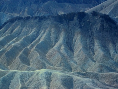
Desolate Landscape
The mountains and the desert in the badlands of California are impressively like my imagination pictures the surface of the Moon. The vegetation is minor and the rock formations feel unfamiliar. There is a certain energy radiating there I am sure. I give that feeling to the many crystals spread amongst the Earth's crust in this area. It seems the light is magnified. It is bright and warm and sure.
The sureness of these badlands leans toward certain death if one did not heed the obvious. It is easy to realize that the power within is much greater than anything human could or would ever be. This California bad land is something spectacular to experience, and it is wise to read the warnings and know them. The last thing anyone would want to do is to get caught out in the wilderness here and be ill prepared.

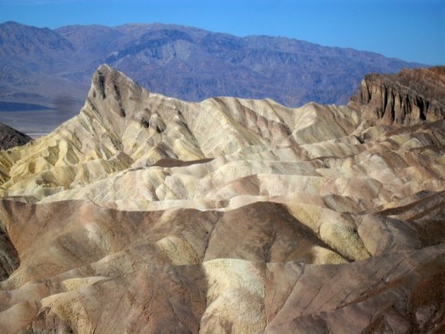
Zabriskie Point
Colorful rock formation, continuing scenes as one might imagine the Moon's surface. This point is breathtaking. The highway is lapped out across this remote wilderness with key viewpoints ready and waiting for vacationers to enjoy. Restrooms and rest areas are the norm. Cars come and go, hopping across the Southern California terrain in search of another vista in all the glory of this Black Mountain range.
Twenty Mule Teams
The overlook is named in recognition of Christian Brevoort Zabriskie (1864-1936), president of the Pacific Coast Borax Company. Borax soap company utilized the local minerals of the mountains to manufacture their soap products. Other areas are also named after elements involving the Borax Company.
These were used in the mining camps to move heavy loads. Teams of twenty mules helped move the borax from the valley floor to be processed into soap. Considering the climate this would seem to be a very difficult task. The rugged nature of this geographical area is extremely harsh, hot and dry. There is relatively little shelter and no water around. If by chance it would rain the water hitting the ground becomes useless for consumption due to the high level of salts in the soil.
To manage and produce anything of value in a climate like Death Valley's is quite the magical feat. Yet the Borax Soap Company did just that from 1883 to 1889. During this time the Twenty Mule Team hauled more than 20 million pounds of borax out of the Valley.


Looking Up Black Mountain

Death Valley Basin
The basin appears to be a large body of water when seen from the peaks of the mountain tops. Looking down it shimmers and calls to your senses. It covers a vast area and looks massive from above. This is not the case.
The shimmer is found in the crystals formed on the crust of the Earth's surface. Death Valley is truly a thin layer of salt crystals boiling and bubbling in the hot California sun. Constantly changing and always on the move due to weather conditions the area has a surreal atmosphere about it.
Badwater California
A popular site for tourists is the sign marking "sea level" on the cliff above Badwater
This is near the lowest point on the Earth's floor in the western hemisphere. Below sea level the Badwater Basin bakes in the dessert sun. The salt crystals dominate the soil surface here. It is an amazing sight of bright white land. You can feel the moisture under the crust as you crunch across the trail that leads to the open floor. As far as you can see it is white inclosed by a wall of mountains all the way around.
We visited in the third week of October. The weather was nice. From the top of the mountain where we started it was a comfortable cool day. Just perfect for hiking without a jacket. At the basin floor it was hotter. Just at 100 degrees you could begin to imagine how miserable it would be during the summer months. They call a point of interest in Death Valley, Furnace Creek and my mind did not have a problem wrapping itself around that title.


