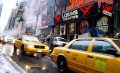
New York City Street and Subway Maps

Historic Maps of the New York City Subway
Find the most popular NYC subway and street maps. Take a tour of the New York City with historic maps from three privately owned transit systems that provided service to the "outer boroughs" that were once independent cities around Manhattan. The IRT, BMT and IND train lines were incorporated into the Metropolitan Transportation Authority (MTA) on June 15, 1953.
The current subway map was recently updated by graphic designer Michael Hertz, who created this version originally in 1979. Go back in time and see the map transform as a reflection of the many changes to one of the largest cities in the world.
All maps via NYC Transit Museum
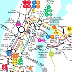
Current NYC subway map - Five cities and three subway systems combined

You can see the large version of this poster on the subway platforms at major staions. The large map is four feet wide and almost five feet tall. Maps on the subway cars are 24 x 30 inches.
Popular maps of New York City - Current subway, bus and sightseeing maps
Waterproof paper maps fold down to the size of a standard business envelope.


1979 Subway Map

In response to widespread public dissatisfaction with the geometric, abstract design introduced in 1972, the MTA developed a new map in time for the subway's 75th anniversary. After community and committee meetings, and testing a prototype, the result, which emphasized the city's geography, was more realistic, and easier to read. The map also introduced a new color-coding system based on trunk lines rather than individual routes.
Neighborhood Maps - Outside the subway turnstyles
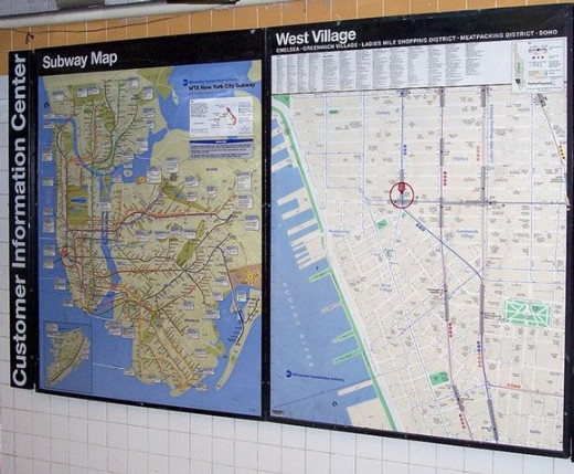
Station subway map and local neighborhood map outside the gates to the subway
in the West Village, near the Meatpacking District, in New York City. Photo: dotpattern
Ask your bus driver for a free map showing the bus route and a scheduled arrival times for all the stops. Information is also posted at the bus stops that lists the number of the bus, a diagram of the bus route and a schedule.
The MetroCard is used to pay for the ride on buses and subways in New York City, and you can get an automatic free transfer between a subway and bus, or between buses. Learn all about the MetroCard in the introduction to the NYC subway and the Transit System. Different types of MetroCards are used for the separate AirTrain service to JFK International Airport and Express Bus service from the outer boroughs.
Interactive transit maps
Subway maps, bus routes and schedules
Go to the Metropolitan Transit Authority (MTA) website to use the interactive maps and timetables online for all subway and bus routes. Subway maps are free at all ticket booths that are located at major stations stops in Manhattan and the boroughs. Large subway maps and local neighborhood maps are displayed outside ticket booths and on station platforms. Simplified maps and diagrams of each subway line are posted in subway cars, and you can download the subway map app for your cellphone for easy, off-line reference.
Books about the subway
From the subway cars and stations to the construction of the tunnels, these books cover every topic about the subway.


Subway Map from 1972
From the Transit Museum: "Simple, elegant, and abstract, the Vignelli subway map has long been considered a landmark in modern graphic design. Its very abstraction, however, made the map difficult to understand and generally unpopular."
NYC Graffiti Art - Subway cars, tunnels and on the street
The evolution of graffiti can be seen on the canvas of city streets and subway trains from the early 1960s to the present day. In all that time, it has remained an outsider art form, mostly independent from the formal art world.


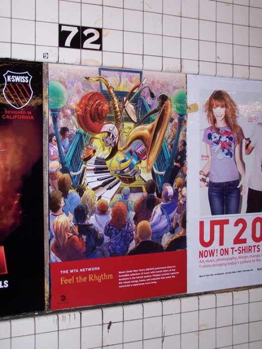
Art and Music in the Subway

Music Under New York's (MUNY) performers share an incredible selection of music with transit riders at key locations in the transit system. You can find musicians and performers in the transfer tunnels at major connection points, at Union Square and Grand Central Station, for example.
In this poster, artist Philippe Lechien captures the robust energy, tunes, and melodies that make the commuter's experience more lively.

Vintage NYC Subway Map 1958

George Salomon's map for the Transit Authority was the first to show the entire system as a whole. Black lines on the map represent the tracks of the Interborough Rapid Transit Company (IRT), green for the BMT, and red for the IND. This map still shows the correct geography of the city in a simplified form.
Feel the Rhythm at 72nd Street - Photograph in the subway
1938 Independent Rapid Transit Map (IRT)

Each of the lines of the Independent Rapid Transit Railroad (IND) is represented by a specific color in this map with sharp lines and cloud-like schematic representations of the boroughs.
Kindle Fire offline NYC subway map - Free Subway and Bus app
NYC Bus & Subway Maps for Android (Google Play)
One map of the subway with touch screen controls to pinch and zoom for offline viewing inside the subway. Five separate maps of the buses in each borough. Turn on settings to allow sideloaded apps on Kindle Fire. Visit Google Play to get the NYC Bus and Subway Map for other Android devices.
1925 Brooklyn Manhattan Transit (BMT)

This early map of the independent Brooklyn Manhattan Transit (BMT) system from 1925 shows routes as thick, exaggerated lines on a simple map based on the real geography of the region. Red lines show the numerous elevated tracks in the transit system at the time, and subway tunnels are shown in black.
Vote for your favorite - Vintage subway posters
Which is your favorite NYC Subway poster?
"Goodbye, everybody!" - New Yorker Cartoon by Robert Leighton
For any questions or comments about the subway maps, please leave a note and I will post an answer back here as soon as possible. When in New York City, simply call 311 for local information and questions about New York City services or major events (available in several languages).