An Appalachian Trail Thru-Hike: Part 3 - Hiking Through Georgia
"Hikers put so much time and energy into the distance they travel, that they weigh very carefully all their options before doing anything that will require much back tracking."

Back Tracking
On the fourth morning of our thru-hike Dave and I woke up on the summit of Blood Mountain, ate our breakfast, shouldered our packs, and started following the white blazes that mark the Appalachian Trail (AT) all the way from Georgia to Maine. We climbed halfway down Blood Mountain before we realized that we were going back down the way we came up the afternoon before. We had hiked a mile or so before we figured out our error. The result was that we had to turn around and hike back up the mountain and start out again, this time going north.
Back tracking is something hikers hate to do. Any time hikers have to travel back over ground just hiked, it feels like wasted effort. That is especially true when the back track is the result of a mistake such as on that morning, but back tracking occurs for many reasons and even though it is not desirable, it is often deliberate. Hikers put so much time and energy into the distance they travel, that they weigh very carefully all their options before doing anything that will require much back tracking. This includes things like whether or not to go down a side trail to see a view, to go to a shelter, to get some water at a spring, or to walk down a road to get to a store for snacks.
For us a half-mile was a significant distance threshold. A half-mile to get some place and a half-mile back means an extra mile of hiking. For an overlook to be worth an extra mile of hiking it must be reputed to be an excellent view. Side trips for water depend on how much water is left in our water bottles and what opportunities were coming up according to guidebooks and intelligence gathered from hikers met coming from the opposite direction. Walking down a road for a store was very tempting. To further prompt us to hike a little further down a road for a store was the chance someone would stop and give us a lift. Often a pickup truck would pullover and a friendly voice would call out “hop into the back boys, I’ll give you a lift to the store”. Then we would be scrambling to the truck, heaving our packs into the pickup bed, and climbing in behind to find a spot to sit amongst the tools, boxes, hay bales, or whatever else was in the pickup bed. Therefore we would often be willing to travel a greater distance along the road to get to a store than along a side trail to get to a view, a spring, or a shelter.
If you want to read this series from the beginning click the link below:
Freeze Dried Meals and Trail Guides
When we finally got going in the right direction, it wasn’t long before we came to a road crossing at a place called Neil’s Gap. There was a store right where the trail intersected the road. The store catered to hikers. It sold a lot of freeze-dried meals. These are meals that are dehydrated and shrink wrapped in foil or plastic. To eat them you cut open the package and add some boiling water to reconstitute the meal. You allow the meal to soak up the water for a period of time before eating. Dave and I had tried freeze dried meals in the past. They had the advantage of being light, compact, and they could stay unspoiled without refrigeration – perfect for backpacking. On top of that, some of them were pretty tasty, but each individual meal was expensive so we stayed away from stocking up on them. We did however get four sodas each and a few candy bars.
One key purchase Dave made at the store was a more detailed and up-to-date trail guide. The one we had been using up till then came from a book called “The Appalachian Hiker” by famed through hiker, Ed Garvey. He had written his original book in 1971 and updated it in 1978. His guide recorded shelters, springs, road crossings, and many other significant landmarks such as mountaintops or river crossings in sequence from south to north with the mileage between the recorded landmarks. While a good guide, it wasn't as comprehensive as the official guides put out by the Appalachian Trail Club (ATC). Dave bought one of the ATC guides which contained entries for all the shelters and road crossings that Ed Garvey's guide did, plus entries for all the peaks the trail climbed with greater detail about water supplies, stores, food and lodging and distance to them from road crossings. The guide Dave purchased covered the entire trail as Garvey's guide did. Later we would discover even more detailed guides that covered sections of the trail and included maps. We hiked on from Neil’s Gap and ended up staying the night at Low Gap lean-to, 13.5 miles from Blood Mountain. We shared the shelter with a solo hiker, not much older than us. We all pitched in to gather some wood and that night we had our first campfire of the trip.
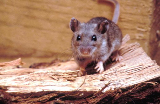
"We cut away the area where the mouse had nibbled the bread and we ate the rest of the loaf."
An Aggressive Mouse
The next morning we found that a mouse had chewed his way into Dave’s pack and had snacked on our loaf of bread. The mouse that chewed through Dave’s pack was the only animal that stole any of our food during the entire trip. Most lean-tos or shelters along the trail are inhabited by mice. Usually they stick to picking up crumbs dropped by hikers during meals. They can also get food if a hiker staying the night at the shelter is careless enough to leave dinner pots and pans out or if they leave their food out in the open. It is usually recommended these days that hikers hang their food from a rope strung between trees. Some shelters have poles with lines strung through eyebolts at the top so it is easy for hikers to hang their food out of reach of critters. At the time we were hiking, that practice was known but was less frequently followed. Dave and I never hung our food and other than this one incident, we never had any problems. Of course we kept a tidy camp. We always washed out our pans and the Tupperware bowls we used as well as our utensils. After every meal we boiled water in our pans for washing up and we wiped everything off with paper towels which we would then burn. We always put all our food, pans, bowls, and utensils away in our packs at night and we zipped up every pocket. We put garbage that couldn't be burned in a plastic garbage bag which we tied up each night and zipped up in a pack compartment. When we slept in the tent we would keep the packs in the tent with us. In shelters we usually leaned our packs against either the back or side wall. If we were sleeping under the stars we leaned our packs against a convenient tree.
As for our loaf of bread, the mouse put a pretty good dent in about four or five pieces midway through the loaf. Dave's pack had about an inch by a half inch hole through the outer pack material on the side that faced his back when he was wearing it. Luckily that meant his back blocked rain from seeping into the pack when he wore it through rainstorms. We cut away the area where the mouse had nibbled the bread and we ate the rest of the loaf. We couldn't throw out the rest of the loaf or we would've been going hungry for lunches.
One more note about mice in shelters: further down the trail we heard stories about a thru-hiker from years past who went by the trail name of Trapper John or something like that. Supposedly he carried mouse traps in his pack. When he stayed in shelters he would bait his traps with peanut butter and set them up at night before he went to sleep. Those who shared shelters with him would often be wakened during the night by a snap and a brief thrashing noise. In the morning Trapper John would count up this kills, deposit them in the words, eat his breakfast, then move on down the trail to the next night’s shelter.
"...we found ourselves walking past and through sprawling rhododendron thickets and some of the individual plants were the size of small trees."
A Different Way to Hike the Trail
We had another day of warm temperatures and we took advantage of it to hike some good distance – 16 miles, but the next day the temperatures cooled down some and we couldn’t get into a good hiking mood so we took lots of breaks. Once we arrived at Dick's Creek Gap picnic area we just decided to stay. It turned out to be a 10 mile day. There was a little spring there and picnic tables to cook our food on and to eat at. While we were there we met some ladies. We talked for a while and it turned out that they were acting as a support team for their friend who was doing the trail in a series of day hikes. At the end of each day she would meet up with her friends at a designated spot and then they would all go somewhere for the night. It sounded like a good way to do the trail – a good meal, a bed, and a shower after each day's hike. The ladies were nice enough to give Dave a lift to a small store down the road while I stayed at the picnic area and watched our packs. Dave came back with snacks and a few meal items, but we knew we still needed to get to Wesser, NC for our first major resupply of the trip. We figured we had about 4 more days of food left in our packs and that would even be stretching it some.
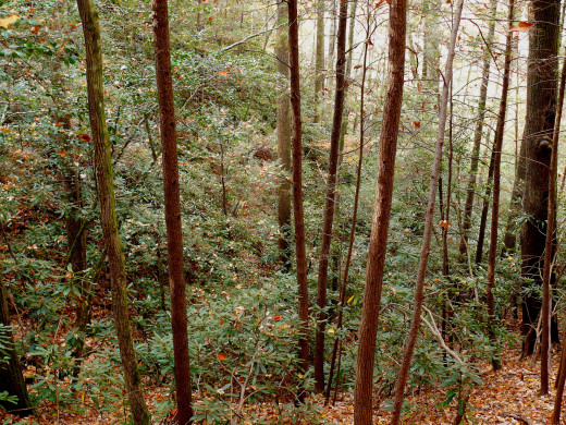
One characteristic of the hiking in Georgia was the amount of wild rhododendron that was growing in the woods we were hiking through. Since there were no leaves on the trees yet, the rhododendron, which keeps its green leaves year-round, was very visible against the brown of fallen leaves and tree trunks. Dave and I were familiar with small rhododendron bushes as ornamental shrubs in New York State. We both had a shrub or two planted around our homes. In Georgia though, we could see that the rhododendrons thrived in the forest. In some situations we could see entire slopes with the understory covered by rhododendron. At other times when we descended into low points between ridges where small streams flowed, we found ourselves walking past and through sprawling rhododendron thickets and some of the individual plants were the size of small trees. I could only imagine what it would have been like hiking the trail in Georgia when those rhododendrons were blooming with their thick clusters of purple flowers. That would have been another great advantage to hiking the trail in sections, the way the woman with her support group was. Then the hiker can choose the most advantageous time to hike the different sections of the trail and see each portion when it is at its most scenic or when the weather tends to be the best.
