Queensland's Best of All Lookout

Springbrook World Heritage National Park
Springbrook World Heritage National Park is situated in the Gold Coast Hinterland, right on the border between Queensland and New South Wales, in Eastern Australia.
This park is a wonderful place to visit for anyone interested in nature and the world around us.
I recently revisited the area and was not disappointed. I knew I loved it, but had forgotten just how beautiful this area of views and waterfalls can be and it was so refreshing to experience again one of my favourite places.

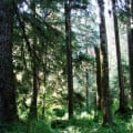
Beautiful Springbrook in the Gold Coast Hinterland.
Take Your Time
The road from the coast to Springbrook rises from near sea-level to over a kilometre high, so there are twists and turns, even 'hairpin bends,' but if you are making a day of it there is no need to hurry.
There are several places to stop and enjoy the beauty of the scenery on the way. Take your time and breathe the fresh, clean mountain air.

The Signpost
In Springbrook, the road is well signposted. Once you reach the tiny village of Springbrook, it is only seven kilometres to the entrance to the Lookout, so there's time to stop on the way and enjoy the scenery.
At this spot pictured below, Purlingbrook stream passes underneath the road, slides over rocks and tumbles down a small waterfall as it grows and makes its way down the mountain.
- If you're driving, watch out for walkers and hikers along the road.
Once, when I was driving quite near here I was delighted to see a shining Golden Oriole fly right across the road. Unfortunately, I've never been able to photograph this beautiful bird that is an icon of the area.

The Springbrook National Park
At the top end of Repeater Station Road, we came to a divided road. Both lead to car-parks. As it is mountainous, there is not much space for parking and the one on the right is the main park. From here steps lead up to the smaller car-park. Here there is space for Handicapped Parking and about three other vehicles. This car-park is right at the entrance to the walking track to the Best of All Lookout.
- As you can see from the photo below, the park is protected. Although it may be tempting in the wildflower season, the only thing you are permitted to take are photos.

The Track to the Best of All Lookout
As you can see from the following photos, which are just a couple from the many that I took, even in the rather bleak winter sunshine there is much to see and enjoy along the way.
There are many places where we noticed that the leaf-mould has been scratched by some creatures, but we did not see any. Perhaps they are nocturnal - or perhaps we made too much noise!


Temperate Rainforest
The walking track through temperate rainforest is made and smooth, so much better than it used to be. Although it does wind up and down a little, it is only 300 metres to the Lookout and it claims to be suitable for all fitness levels. It is fairly narrow, but there are places a little wider where people can stop for a moment to catch their breath or take photograph.
The temperate rainforest offers a variety of vistas and it's pleasant to walk slowly to enjoy it. I especially love all the mosses, lichens and tiny ferns.

The Best of All Lookout
Wow! We arrived at the Best of All Lookout! And the vista was just as breath-taking as I remembered it.
- We had been walking along the extensive northern edge of a huge ancient volcano that is known as the Green Cauldron.
- Apparently it was last active about ten million years ago.
Before us was a very interesting and informative board at the Lookout that told us about the scene before us and explained what happened in the area so long ago.

Looking South East
The highest peak is quite pointed and we know it as Mt Warning.
The Original Occupants
- Long before the advent of white settlement, an aboriginal group, the Kombumerri people, lived in the area, usually down nearer the coast.
- The Kombumerri probably came up into the cool mountains to escape the hot, humid summer weather, as stone tools have been found nearby.
- The Kombumerri name for Mt. Warning is Wollumbin, which means 'cloud catcher,' such an evocative name.

Looking North East
The border between Queensland and New South Wales, when we look north east, runs along the closest mountain, Springbrook Mountain. Another viewing point, the Bilborough Lookout, is situated on its tip.
Just beyond that, on a clear day, we can see the high rises of the Twin Towns, Coolangatta (Qld) and Tweed Heads (NSW). All along beyond the land is the coast and the blue expanse of the Pacific Ocean.
It was a lovely stroll through the forest and the view at the end was certainly worth it, and this is just one part of Springbrook World Heritage National Park.