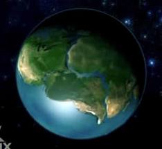
Pangaea

Our Changing Earth
CONTINENTAL DRIFT AND PLATE TECTONICS
So we begin with the story of the great continent of Pangea, and Alfred Wegener (1880-1930), a German meteorologist who said the continents were all one one big land mass as evidenced by how well they all fit together like puzzle pieces. He later backed this up with fossil evidence from opposite sides of the Atlantic Ocean, evidence of matching rock formations on either coast, as well as tropical fossils found in Antarctica, but his fellow scientists found it all quite unconvincing. Wegener was proposing the land mass was in motion and the continents had been torn apart by some force. Although most scientists agreed with the theory, he failed to produce the mechanism by which the continents could move. He said somehow they moved through the ocean, but no one accepted that continents could simply move across the ocean without being torn apart. Wegener devoted the rest of his life to trying to find more evidence but unfortunately, he froze to death in Greenland still searching. (Trefil, 2010) (USGS, 2011)
It wasn’t until after World War II that scientists would again take a look at the ocean floor and find some anomalies that might prove Wegener’s theory after all. When they mapped the ocean floors they thought they would find a flat surface with run off from the continents, but instead they found a dramatic landscape of mountains, valleys, and canyons. (Trefil, 2010)

In the 1960’s scientists began to study the ocean floor and its magnetism. There are magnetic parts to the rock when it is in its lava state and before it cools, it will align with the magnetic north pole, which the scientists also note, have changed throughout the life of the earth. (The reason is unknown) Through this study, and comparing stripes of magnetic rock on the bottom of the Atlantic and Pacific Ocean, scientists came up with the concept of sea floor spreading. Each time new lava makes its way to the surface, the magnetic parts align with the current magnetic north – at the same time the new rock is pushing the continents apart and over long periods of time, a striping pattern can be seen in the rock. This data was used to also tell the age of the ocean floor. Rocks near the fissures and the mid-Atlantic Ridge were quite young. Rocks closer to the East US coastlines were older. (Trefil, 2010)
Radio astronomy was used to confirm the finding of sea floor spreading and the fact that the continents are moving farther apart. The distance between North America and Europe grows by 5cm or 2 inches per year. The study of all of these sciences; the rock dating, paleomagnetism, ocean floor spreading, and other data is called plate tectonics. Scientists today accept this concept because of all of the data, and the mechanism by which the theories are proven. Wegener had only a theory and very little evidence to back it up. He, unfortunately, did not have the technology to prove his theory, which was only the tip of the iceberg, so to speak. (Trefil, 2010) (Sander, 2012)

The process of scientific method and theory development is a six step process: Observation, theory, prediction, tests, results, conclusions. The scientist starts with an observation. For purposes of explanation I’m going to be really simplistic. He puts a pot of water on the stove and lights the fire. He comes back in half an hour and the water is gone. That is the observation. The theory is not that that water magically disappeared, because this guy is a scientist. He thinks the water went somewhere. He thinks (theory) that applying heat to water causes it to turn into a gas and evaporate. (He’s not that smart really, his friend told him about it the other day but if his friend did it, he should be able to replicate the same experiment.) (Trefil, 2010)
He predicts that he can do the same thing, (add fire to the pot to make the water disappear) but “catch some of the water in action as vapor if he uses a lid. He tests this theory and puts the water on the stove in a pot with a lid and goes about his business. He hears a gurgling and comes back. He lifts the lid slowly and vapor is released. “Eureka!” he screams and dances around. The result is that yes, if he adds heat to the water, he can make water vapor. He concludes that water can be both a liquid and a gaseous vapor.
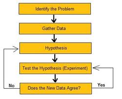
I told you it was simplistic. But that’s how tedious science can be. Every idea must be tested and retested so that someone else can repeat it under the same conditions then it is known as a scientific fact and follows a scientific law of something.
This method helps us understand our natural world. The world behaves according to certain established laws and rules. They’re not made up, but tried and tested facts like the law of gravity. On earth there is a specific law of gravity, a law of motion, and certain things that are always true. If something seems to defy a specific principle, there is an explanation (usually – or we just don’t know yet). There are a set of testable theories that make scientific laws verifiable. There are new discoveries all the time. How cool would it have been to have been around when electricity was discovered and harnessed?
In our natural world, it is hard yet not impossible to predict things like tsunamis and earthquakes because of the grand scale of the earth. There are signs and precursor events leading up to things like a volcano eruption…but can we predict the week, month, day, hour or a volcanic event? And if there wasn’t enough time for a full evacuation, how does one proceed? What if the prediction is wrong? The earth is still a mystery in many ways.
Plate tectonics provides the mechanism for continental drift because it explains how the earth’s surface is broken up into about twelve tectonic plates on top of the earth’s mantle. In between these plates are fissures or cracks that sometimes allow these plates to move. The science behind the movement of the plates can be explained through subduction and convergent plate boundaries. Through this process the earth is not getting larger, but rather is folding under and being recycled. (Trefil, 2010)

Subduction happens when there is new rock being formed from magma, and it forces one end of a crustal plate to be pushed below the edge of another. And with all of the plates moving together, no plate can shift without affecting another, even if it is thousands of miles away. While the Atlantic Ocean is getting wider and pushing the continents of Africa and South America away from each other; the Pacific Ocean plates are busy subducting . As two plates pull away from each other this is called divergent plate boundaries, as in the Atlantic Ocean where the continents are moving apart. In the Pacific Ocean, where the subduction is going on, the crust is pushed below the edge of other plates and recycled; these are called the convergent plate boundaries. (Giamportone & Booker, 2010)
The third kind of tectonic plate boundary is the transform –fault boundary. This occurs when two faults are sliding horizontally past each other. Most of these faults are in the ocean but the famous one on land is the San Andreas Fault which takes up roughly 2/3 the length of California. These two plates are constantly rubbing against each other. Land on the Pacific plate is moving in a North Westerly direction as opposed to the plate to the right (the North American plate). Earthquakes occur along fault lines such as these, on land or in the ocean. (Giamportone & Booker, 2010)


The earth is not getting any bigger. If the ocean floor is spreading on the Atlantic side and pushing the continents farther apart, that distance must be made up on the opposite ends somewhere. The area in the Pacific and Indian Oceans, however, is not spreading. It is known as The Ring of Fire. From Chile to Mexico to California to Alaska (Aleutian Islands) then Russia (Kamchtka Peninsula), Japan and Micronesia, then New Zealand. This is where all of the subduction activity is occurring. Rings of volcanoes (Over 75% of the world’s volcanoes are in this area.), lava flows, moving earth, fault lines, tsunamis; this is a place of motion. Here the sea floor is folding, crunching, and the tectonic plates are subducting under each other. (Giamportone & Booker, 2010) (Svitil, 2011)
The Himalayas are forming (still) by a different process, but still violent. (Funny how this violent process can be so beautiful) They are being formed by the continent riding on top of two converging plates; the land has collided and is being forced up sharply. Compared to the Smoky Mountains on our East Coast, they are very young. If it was ocean material riding on top of these converging plates the result would be a deep ocean trench. (Trefil, 2010)
This has been an in-depth look at plate tectonics and a simple overview of the scientific method of looking at things. The main thing to remember is that the Atlantic Ocean is getting larger, due to the process of sea floor spreading, and the Ocean has a feature of Mountain ridges and valleys and plateaus that has been mapped. The Pacific Ocean is much more dynamic in terms of seismic activity, volcanic activity and subduction.

REFERENCES
Giamportone , J., & Booker, W. (2010). Plate tectonics: Plate boundaries. Retrieved from http://www.platetectonics.com
Sander, L (February 1, 2012). Moving Plates. Live Chat #9
Svitil, K. (2011). Savage earth: Ring of fire. Retrieved from http://www.pbs.org/wnet/savageearth/hellscrust/html/sidebar3.html
Trefil & Hazen. (2010). The Sciences: An Integrated Approach. (6th ed.). Hoboken, NJ: Wiley & Sons Inc. www.wileyplus.com
USGS , (2011, September 19). Plate tectonics: Historical perspective. Retrieved from http://pubs.usgs.gov/publications/text/historical.html