Crossing Carolina - The Meteor Lakes Byway

The Meteor Lakes Byway has been designated by the North Carolina Department of Transportation as one of 45 scenic byways in the state. These routes have been selected because they embody the diverse beauty, culture, history, and geography of the state while providing travelers with a less-hectic alternate route. The routes are clearly marked with highway signs and the Scenic Byways logo.
The Meteor Lakes Byway
Length: 39 miles
Drive Time: 45 minutes
Counties: Bladen, Cumberland, Sampson
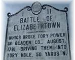
Travel N.C. 242 North in Elizabethtown from the intersection with N.C. 53 near U.S. 701, in Bladen County. Elizabethtown, which was settled in 1773, is believed to have been named for Queen Elizabeth I. The town was the site of the 1781 Revolutionary War Battle of Elizabethtown, where Whigs broke Tory power by driving them into a deep ravine on the banks of the Cape Fear River. The Tories were colonials who were devoted to England.) The ravine is now known as the Tory Hole. Bladen County was named for Martin Bladen, Commissioner of Trade and Plantations from 1717 to 1746.
Cross the Cape Fear River just outside the Elizabethtown city limits and enter the Bladen Lakes State Forest. About 4 miles north of the Cape Fear is Jones Lake, the closest of the meteor lakes to N.C. 242. Jones Lake State Park and the nearby Singletary Lake Group provide camping and recreation sites. First named Woodward for a local Justice of the Peace in 1734, the name of the lake was changed later to Jones in honor of a prominent local landowner. The park was created in 1939 with more than 2,000 acres of land. Jones Lake along with White Lake, Singletary Lake and Lake Waccamaw are all described as being Carolina Bays. These are oval depressions believed to have been formed by ancient meteor showers. These depressions may include lakes, swamps, pocosins, savannas and peat beds. The depressions held water and decomposed organic material over the years to eventually create the fertile farmlands seen along this route. These lakes, with the exception of Lake Waccamaw, are located in the Bladen Lakes State Forest and serve as popular recreational areas.
From Jones Lake pass through the Turnbull Creek Valley. The fields to the right are part of the Big Colly and Cypress Creek Bays. On the 3 mile drive through Cumberland County, notice the Big White Pocosin on the left. At the Cumberland and Sampson County line, cross over the South River. Five miles north of the county line is the community of Roseboro. It originally was established in 1839 as Owensville. In 1891, the name was changed to honor George Rose, Chief Counsel for the Cape Fear & Yadkin Valley Railroad. Just north of Roseboro, cross the Little Coharie Creek. From Roseboro it is 3 miles to the town of Salemburg. Salemburg was founded in 1874 and named for the Salem Academy located in the town. The school was the forerunner of the North Carolina Justice Academy where state law enforcement officers obtain advanced education. As you pass through Salemburg, look for the mural depicting the heritage of the area.
Cumberland County, founded in 1754, was named for the Duke of Cumberland - the second son of George II - who was successful at the Battle of Culloden. Ironically, the area was settled by Scottish Highlanders, the people defeated by the Duke of Cumberland.
The route ends at the junction with U.S. 421, about 4 miles south of Spivey's Corner in Sampson County. Sampson County was named for John Sampson, a member of the House of Commons under North Carolina's royal governors. Located at the headwaters of the Little Coharie Creek, Spivey's Corner is well-known as the site of the annual Hollering Contest. From Spivey's Corner it is 7 ½ miles to the U.S. 13 and I-40 interchange at Newton Grove.
Other Piedmont North Carolina Byways:


