North Carolina - The Geography Class

North Carolina is located between the parallels 34° and 36°30' north latitude, and between the meridians 75°30' and 84°30' west longitude. It is bordered by Virginia on the north, South Carolina on the south, Georgia on the southwest, Tennessee on the west, and by the Atlantic Ocean on the east.
The mean breadth of the state from north to south is about 100 miles, with an extreme breadth of 180 miles. The extreme length from east to west is 500 miles. Its boundaries encompass 52,280 square miles.
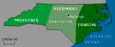
The state has three main geographic regions: the coastal plain, which consists of roughly the eastern 45% of the state; the Piedmont region, which occupies the middle 35%; and the mountains/foothills.
The regions are divided by their elevation. The Coastal Plain extends to areas below 400 feet above sea level, the Piedmont contains areas between 400 and 1,500 feet, and the Mountain region includes areas from 1,500 feet to the highest Appalachian peaks at more than 6,600 feet.
Off the coast the Outer Banks form two sounds- Albemarle Sound in the north and Pamlico Sound in the south. They are the two biggest landlocked sounds in America. Inland, the coastal plain is relatively flat, with rich soil that is good ideal for growing cotton, tobacco, and soybeans. The coastal plain is the state's most rural region, and agriculture continues to be important to the economy. The major rivers in this section, the Neuse River, Tar River, Pamlico River, Cape Fear River, and Roanoke River, are wide and move slowly for the most part.
The coastal plain transitions to the Piedmont region along a line marking the elevation at which waterfalls are found in streams and rivers. The Piedmont region of the state is the most urbanized and densely-populated section. All five of the state's largest cities are located in the Piedmont. The terrain consists of gently rolling countryside broken up by hills or low mountain ridges. A number of small mountain peaks and ranges are located in the Piedmont. Some of these include Pilot Mountain, Sauratown Mountain, the King Pinnacle, the Uwharrie Mountains, Crowder's Mountains, the Brushy Mountains, and the South Mountains. The Piedmont ranges from about 300-400 feet elevation in the east to over 1,000 feet in the west. The major rivers of the Piedmont, like the Catawba and the Yadkin, tend to be narrow and fast-flowing.
The western section of the state is part of the Appalachian Mountain chain, which extends almost from the mouth of the Saint Lawrence River to the Gulf of Mexico. Ranges of the Appalachians located in the state include the Great Smoky Mountains, the Blue Ridge Mountains, The Pisgah Mountains, the Great Balsam Mountains, and the Black Mountains. The Black Mountains are the highest in the Eastern United States, peaking with Mount Mitchell at 6,684 feet. This is the highest point east of the Mississippi River. Agriculture is still important in this region, however, tourism has become the primary industry in the mountains. Due to the higher altitudes, the climate can differ significantly from other areas of the state. Subfreezing temperatures and large snowfalls are common in the Winter.
North Carolina has 17 major river basins. Five of these river basins - the Hiwassee, Little Tennessee, French Broad, Watauga, and the New - are part of the Mississippi River Basin, which drains to the Gulf of Mexico. All others flow to the Atlantic Ocean. Of the 17 basins, 11 originate within the state of North Carolina, but only four are contained entirely within the state's borders - the White Oak, Cape Fear, Neuse, and Tar-Pamlico.

 in Western North Carolina")


