ArtsAutosBooksBusinessEducationEntertainmentFamilyFashionFoodGamesGenderHealthHolidaysHomeHubPagesPersonal FinancePetsPoliticsReligionSportsTechnologyTravel

North Carolina's Scenic Nantahala Byway

Updated on November 28, 2007

The Nantahala Byway has been designated by the North Carolina Department of Transportation as one of 45 scenic byways in the state. These routes have been selected because they embody the diverse beauty, culture, history, and geography of the state while providing travelers with a less-hectic alternate route. The routes are clearly marked with highway signs and the Scenic Byways logo.

The Nantahala Byway :

Length: 43 miles

Driving Time: 1 ½ hours

Counties: Cherokee, Graham, Jackson, Swain

Begin the byway in Marble, where the four lanes of U.S. 19/74/129 take motorists through 8 miles of farming valley to Andrews. The community of Marble, founded in 1911, was so named because it is near the state's largest deposit of marble. This marble is of such quality that it was used extensively at Arlington National Cemetery. The valley has very rich soil which helps the crops. The soil was deposited by the Valley River, which flows on the eastern side of the valley toward the Hiawasee River in Murphy.

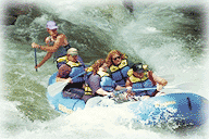
At Andrews, named for the man who developed the Western North Carolina Railroad, turn right onto U.S. 19 Business and proceed through this turn-of-the-century mountain town. Meet back with U.S. 19/129 on the north side of town. From Andrews it is approximately seven miles to the community of Topton. The Indian Lakes Scenic Byway intersects at this point and runs north on U.S. 129. For the next 20 miles, you will be passing through the Nantahala Gorge. Cross the Nantahala River. At the Clay and Macon County Line look for the 360-foot Camp Branch Falls just before entering the community of Nantahala, which was founded in 1882. This is where the gorge's true nature begins to be prevalent. The Nantahala Gorge was called the "Land of the Midday Sun." From this phrase, the Cherokee Indians got the name "Nantahala," because of its steep walls and depth. This is a popular world-class white-water rafting spot. During the warmer months, many rafting companies provide tours. Kayaking and canoeing enthusiasts take advantage of it well into the winter.

The route occasionally provides a glimpse of the Great Smoky Mountain Railroad, which passes through the gorge following U.S. 19/74. Visitors can take a ride and enjoy the scenery at a different pace.

It is 7 miles from Nantahala to the community of Wesser, named for a hunter who lived here. At Wesser, the Nantahala River and the road no longer run parallel. Cross the Little Tennessee River 2 miles north of Wesser on U.S. 19/74. From the community of Lauada, a mile north of the Little Tennessee, continue 4 miles on the divided highway part of U.S. 19/74 to the second Bryson City exit. Bryson City, founded in 1887, sits in a bowl formed by the Tuckasegee River and the Cowee Mountain Range. Exit and turn left onto Spring Street, following for about ½ mile on 4 lanes to the stoplight at Main Street (U.S. 19 Business). Turn left onto Main and go 1/10 of a mile to the stoplight at Slope Street (S.R. 1323). Turn right at the light onto Slope Street. Cross the Tuckasegee River and turn right on Gibson Avenue (S.R. 1321). Turn right again onto Everett Street (S.R. 1364) at the Great Smoky Mountain Railroad station. Turn left at the Swain County Courthouse back onto Main Street (U.S. 19 Business). Follow U.S. 19 Business about 2 miles and turn right onto Hyatt Creek Road (S.R. 1168). For the next three miles follow Hyatt Creek Road as it parallels the Tuckasegee River. The road passes through portions of the Eastern Band of the Cherokee Nation's reservation. The Qualla Reservation got its name from the Cherokee word meaning "old woman" for an old Indian woman who lived on these lands. Established in 1838 with more than 63,000 acres, it is the largest Indian reservation east of the Mississippi.

Turn right onto U.S. 19 Business after crossing the river. Continue on U.S. 19 for 7/10 of a mile. Turn right onto Old U.S. 19 (S.R. 1195), cross the Oconaluftee River, just above its junction with the Tuckasegee. Follow S.R. 1195 for 1.8 miles to the Jackson County line. At this point it becomes Old U.S. 19 (S.R. 1531). The route ends about a mile later at Whittier, where S.R. 1531 meets with U.S. 74.

working

This website uses cookies

As a user in the EEA, your approval is needed on a few things. To provide a better website experience, hubpages.com uses cookies (and other similar technologies) and may collect, process, and share personal data. Please choose which areas of our service you consent to our doing so.

For more information on managing or withdrawing consents and how we handle data, visit our Privacy Policy at: https://corp.maven.io/privacy-policy

Show Details
Necessary
HubPages Device IDThis is used to identify particular browsers or devices when the access the service, and is used for security reasons.
LoginThis is necessary to sign in to the HubPages Service.
Google RecaptchaThis is used to prevent bots and spam. (Privacy Policy)
AkismetThis is used to detect comment spam. (Privacy Policy)
HubPages Google AnalyticsThis is used to provide data on traffic to our website, all personally identifyable data is anonymized. (Privacy Policy)
HubPages Traffic PixelThis is used to collect data on traffic to articles and other pages on our site. Unless you are signed in to a HubPages account, all personally identifiable information is anonymized.
Amazon Web ServicesThis is a cloud services platform that we used to host our service. (Privacy Policy)
CloudflareThis is a cloud CDN service that we use to efficiently deliver files required for our service to operate such as javascript, cascading style sheets, images, and videos. (Privacy Policy)
Google Hosted LibrariesJavascript software libraries such as jQuery are loaded at endpoints on the googleapis.com or gstatic.com domains, for performance and efficiency reasons. (Privacy Policy)
Features
Google Custom SearchThis is feature allows you to search the site. (Privacy Policy)
Google MapsSome articles have Google Maps embedded in them. (Privacy Policy)
Google ChartsThis is used to display charts and graphs on articles and the author center. (Privacy Policy)
Google AdSense Host APIThis service allows you to sign up for or associate a Google AdSense account with HubPages, so that you can earn money from ads on your articles. No data is shared unless you engage with this feature. (Privacy Policy)
Google YouTubeSome articles have YouTube videos embedded in them. (Privacy Policy)
VimeoSome articles have Vimeo videos embedded in them. (Privacy Policy)
PaypalThis is used for a registered author who enrolls in the HubPages Earnings program and requests to be paid via PayPal. No data is shared with Paypal unless you engage with this feature. (Privacy Policy)
Facebook LoginYou can use this to streamline signing up for, or signing in to your Hubpages account. No data is shared with Facebook unless you engage with this feature. (Privacy Policy)
MavenThis supports the Maven widget and search functionality. (Privacy Policy)
Marketing
Google AdSenseThis is an ad network. (Privacy Policy)
Google DoubleClickGoogle provides ad serving technology and runs an ad network. (Privacy Policy)
Index ExchangeThis is an ad network. (Privacy Policy)
SovrnThis is an ad network. (Privacy Policy)
Facebook AdsThis is an ad network. (Privacy Policy)
Amazon Unified Ad MarketplaceThis is an ad network. (Privacy Policy)
AppNexusThis is an ad network. (Privacy Policy)
OpenxThis is an ad network. (Privacy Policy)
Rubicon ProjectThis is an ad network. (Privacy Policy)
TripleLiftThis is an ad network. (Privacy Policy)
Say MediaWe partner with Say Media to deliver ad campaigns on our sites. (Privacy Policy)
Remarketing PixelsWe may use remarketing pixels from advertising networks such as Google AdWords, Bing Ads, and Facebook in order to advertise the HubPages Service to people that have visited our sites.
Conversion Tracking PixelsWe may use conversion tracking pixels from advertising networks such as Google AdWords, Bing Ads, and Facebook in order to identify when an advertisement has successfully resulted in the desired action, such as signing up for the HubPages Service or publishing an article on the HubPages Service.
Statistics
Author Google AnalyticsThis is used to provide traffic data and reports to the authors of articles on the HubPages Service. (Privacy Policy)
ComscoreComScore is a media measurement and analytics company providing marketing data and analytics to enterprises, media and advertising agencies, and publishers. Non-consent will result in ComScore only processing obfuscated personal data. (Privacy Policy)
Amazon Tracking PixelSome articles display amazon products as part of the Amazon Affiliate program, this pixel provides traffic statistics for those products (Privacy Policy)
ClickscoThis is a data management platform studying reader behavior (Privacy Policy)