ArtsAutosBooksBusinessEducationEntertainmentFamilyFashionFoodGamesGenderHealthHolidaysHomeHubPagesPersonal FinancePetsPoliticsReligionSportsTechnologyTravel

North Carolina's Scenic Waterfall Byway

Updated on November 28, 2007

The Waterfall Byway has been designated by the North Carolina Department of Transportation as one of 45 scenic byways in the state. These routes have been selected because they embody the diverse beauty, culture, history, and geography of the state while providing travelers with a less-hectic alternate route. The routes are clearly marked with highway signs and the Scenic Byways logo.

The Waterfall Byway :

Length: 98 miles

Driving Time: 3.5 hours

Counties: Cherokee, Clay, Jackson, Macon, Transylvania

Begin following the winding Waterfall Byway west along U.S. 64 at the intersection with N.C. 215, north of Rosman in Transylvania County. This byway gets its name from the 200 waterfalls near the route. The county in which the route begins is known as the ‘Land of Waterfalls.'

Cross the French Broad River, whose Cherokee name means "racing waters," near Rosman at the beginning of the route. It is about 7 miles to the curve where U.S. 64 crosses the Toxaway River at Toxaway Falls on the left and Lake Toxaway on the right.

From Toxaway, it is about 3 miles into the Sapphire Valley resort area. Pass by Lakes Fairfield and Sapphire before crossing the Horse Pasture River. The town of Cashiers, located at the intersection with N.C. 107, is about 10 miles from Toxaway Falls. The headwaters of the Chatooga River are within the town's limits.

From Cashiers it is 4 miles to Cowee Gap. From the gap, at the headwaters of the Cullasaja River, it is 8 miles to the town of Highlands. This is the highest incorporated community on the east coast. Follow U.S. 64 through this resort town, which was founded in 1875. Highlands was started here because it lies at the intersection of lines formed from from Baltimore to New Orleans and Chicago to Savannah.

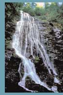
The 120-foot drop of Bridal Veil Falls is 2 miles west of Highlands. Dry Falls, located about one mile west of Bridal Veil, is on the left. This fall is so named because you can walk underneath the roaring water without getting wet. The water from this fall flows into the Cullasaja River to the south. Enter the Cullasaja Gorge, 6 miles west of Dry Falls. The gorge is formed by the Cullasaja River as it flows west into the Little Tennessee River.

About four miles from Dry Falls are the Cullasaja Falls. This cascade drops 310 feet in one-half mile. Also, enjoy the views of the Smoky Mountains and the Pisgah and Nantahala National Forests, while possibly spotting falcons in the trees.

From the Cullasaja Falls, it is 2 miles to the community of Gneiss, which is named for the metamorphic rock that is abundant in the area. From Gneiss, it is about 5 miles to the community of Cullasaja. From there it is 2 ½ miles to the U.S. 23/441 interchange with U.S. 64 in Franklin.

Follow U.S. 23/441 South and U.S. 64 about 7 ½ miles to Cartoogechaye. The nearby mountains are part of the Nantahala Mountain range in the Nantahala National Forest. About 4 miles west, cross Winding Stair Gap, one of the early western passages along the Appalachian Trail. From here it is 2 miles to the community of Rainbow Springs. It is 1.7 miles to Black Gap, on the line between Clay and Macon counties.

While driving the 10 miles along the crests of the Chunky Gal Mountains, enjoy the scenic overlooks. It is about 8 ½ miles to the town of Hayesville. About 4 miles east of Hayesville, you will pass by Lake Chatuga, known as the "Crown Jewel" of the Tennessee Valley Authority lakes. Located in town is the site of Fort Hembree, a gathering place for the Cherokees who left this part of the country for Oklahoma on what is known as the "Trail of Tears."

About seven miles west of Hayesville, turn left onto Settawig Rd. (S.R. 1135) and follow it for 2 ½ miles towards Brasstown. The John C. Campbell Folk School, where craftsmen learn trades such as pottery, weaving and blacksmithing, is located in town. From Settawig Rd. turn right onto Phillips Rd. (S.R. 1100) for 1/10 of a mile to Brasstown Rd. (S.R. 1134). Turn left and follow Brasstown Rd. for 3/10 of a mile then turn right onto Cheringhelli Rd. (S.R. 1558). Follow Cheringhelli Rd. for 6.5 miles where the route ends in Murphy at the intersection with US 19/129 Bypass. Murphy is the site of Fort Butler, a frontier fort in the early 1800s and a temporary stockade for the Cherokee who were on the "Trail of Tears." Located at the junction of the Hiawasee and Valley Rivers, the town also was an early trading post. It is the southern terminal of the Great Smoky Mountains Railway.

Other scenic byways near this route are the Nantahala Byway which begins north of Murphy in Marble and the Forest Heritage Scenic Byway, which ties in with the beginning of this route.

working

This website uses cookies

As a user in the EEA, your approval is needed on a few things. To provide a better website experience, hubpages.com uses cookies (and other similar technologies) and may collect, process, and share personal data. Please choose which areas of our service you consent to our doing so.

For more information on managing or withdrawing consents and how we handle data, visit our Privacy Policy at: https://corp.maven.io/privacy-policy

Show Details
Necessary
HubPages Device IDThis is used to identify particular browsers or devices when the access the service, and is used for security reasons.
LoginThis is necessary to sign in to the HubPages Service.
Google RecaptchaThis is used to prevent bots and spam. (Privacy Policy)
AkismetThis is used to detect comment spam. (Privacy Policy)
HubPages Google AnalyticsThis is used to provide data on traffic to our website, all personally identifyable data is anonymized. (Privacy Policy)
HubPages Traffic PixelThis is used to collect data on traffic to articles and other pages on our site. Unless you are signed in to a HubPages account, all personally identifiable information is anonymized.
Amazon Web ServicesThis is a cloud services platform that we used to host our service. (Privacy Policy)
CloudflareThis is a cloud CDN service that we use to efficiently deliver files required for our service to operate such as javascript, cascading style sheets, images, and videos. (Privacy Policy)
Google Hosted LibrariesJavascript software libraries such as jQuery are loaded at endpoints on the googleapis.com or gstatic.com domains, for performance and efficiency reasons. (Privacy Policy)
Features
Google Custom SearchThis is feature allows you to search the site. (Privacy Policy)
Google MapsSome articles have Google Maps embedded in them. (Privacy Policy)
Google ChartsThis is used to display charts and graphs on articles and the author center. (Privacy Policy)
Google AdSense Host APIThis service allows you to sign up for or associate a Google AdSense account with HubPages, so that you can earn money from ads on your articles. No data is shared unless you engage with this feature. (Privacy Policy)
Google YouTubeSome articles have YouTube videos embedded in them. (Privacy Policy)
VimeoSome articles have Vimeo videos embedded in them. (Privacy Policy)
PaypalThis is used for a registered author who enrolls in the HubPages Earnings program and requests to be paid via PayPal. No data is shared with Paypal unless you engage with this feature. (Privacy Policy)
Facebook LoginYou can use this to streamline signing up for, or signing in to your Hubpages account. No data is shared with Facebook unless you engage with this feature. (Privacy Policy)
MavenThis supports the Maven widget and search functionality. (Privacy Policy)
Marketing
Google AdSenseThis is an ad network. (Privacy Policy)
Google DoubleClickGoogle provides ad serving technology and runs an ad network. (Privacy Policy)
Index ExchangeThis is an ad network. (Privacy Policy)
SovrnThis is an ad network. (Privacy Policy)
Facebook AdsThis is an ad network. (Privacy Policy)
Amazon Unified Ad MarketplaceThis is an ad network. (Privacy Policy)
AppNexusThis is an ad network. (Privacy Policy)
OpenxThis is an ad network. (Privacy Policy)
Rubicon ProjectThis is an ad network. (Privacy Policy)
TripleLiftThis is an ad network. (Privacy Policy)
Say MediaWe partner with Say Media to deliver ad campaigns on our sites. (Privacy Policy)
Remarketing PixelsWe may use remarketing pixels from advertising networks such as Google AdWords, Bing Ads, and Facebook in order to advertise the HubPages Service to people that have visited our sites.
Conversion Tracking PixelsWe may use conversion tracking pixels from advertising networks such as Google AdWords, Bing Ads, and Facebook in order to identify when an advertisement has successfully resulted in the desired action, such as signing up for the HubPages Service or publishing an article on the HubPages Service.
Statistics
Author Google AnalyticsThis is used to provide traffic data and reports to the authors of articles on the HubPages Service. (Privacy Policy)
ComscoreComScore is a media measurement and analytics company providing marketing data and analytics to enterprises, media and advertising agencies, and publishers. Non-consent will result in ComScore only processing obfuscated personal data. (Privacy Policy)
Amazon Tracking PixelSome articles display amazon products as part of the Amazon Affiliate program, this pixel provides traffic statistics for those products (Privacy Policy)
ClickscoThis is a data management platform studying reader behavior (Privacy Policy)