Hiking and Climbing Mount Whitney on the Mountaineer's Route in the Winter.
Mt. Whitney
About Mount Whitney
Climbing the Mountaineer's Route on Mt. Whitney provides a challenging alternate route to the summit, separate from the main trail that most hikers take. Climbing it in the winter, or in the spring after a snow (our conditions) can be an especially enjoyable, but potentially dangerous endevour.
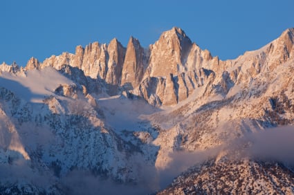
Mt. Whitney rises 14,494 feet (or more depending on the source) above sea level, making it the highest peak in the "lower 48" states. Many hikers each year get permits to ascend and most do it by way of the main trail that winds from the Whitney Portal at an altitude of 8,360 feet to the summit. Taking this route leads you up 11 miles of trail, making the roundtrip 22 miles. Each year, hikers challenge themselves to do this in a day and some succeed.
The Mountaineer's Route also leads from the Portal to the summit, but does it in less than 5 miles. Obviously, it's quite steep in spots to reach the top in less than half the distance of the trail.
It's been a few years since I've been on the Mountaineer's Route, and some details are fuzzy, but some highlights stick with me and are shared here. There are many good guidebooks that give specific info about the climb. If you plan an ascent, read it and reread it until the route is memorized and imprinted in your mind.
Obtaining a Permit for Mt. Whitney and Getting There.
The portal road to Mount Whitney is accessed from Highway 395 in Lone Pine, CA. But before you can go, you need a permit. Permits are required to use the Mt. Whitney Trail, but it's a bit more confusing for the Mountaineer's Route and requirements seem to change from time to time. The best bet is to call 760-873-2483 up to 6 months in advance and ask what your requirements are. There is a permit quota from May 1 to November 1 for the peak hiking season. You may require a permit by lottery for a day hike but not for an overnight trip on the Mountaineer's Route.
According to the USDA Forest Service Website...
"Wilderness permits are required year-round for all visitors entering the Mt Whitney Zone. Reservations are only available for trips that begin during the quota period, from May 1 through November 1.
Day Use Permit: If the entire trip will be on one calendar date and you will enter the Mt. Whitney Zone, a Day Use permit is required. Day Use includes all routes (access to Mountaineer’s Route, East Face/Buttress routes, Mt Russell). No consecutive day use, if trip is more than one calendar date an Overnight permit is required.
Overnight permit (can be multi-night): Trips lasting one night or more that start on the Mt. Whitney trail require an Overnight permit. This includes trips that will end elsewhere (i.e. Pacific Crest and John Muir trails). Day permit can not be used as part of an overnight trip to pass through the area. Mt Whitney Overnight use does not include all routes. Entry via North Fork of Lone Pine Creek to access the Mountaineer’s Route, East Face /Buttress, & Mt. Russell is a different permit (NOT in lottery)."
We (two of us) climbed in April so, as instructed previously, we walked into the ranger station, filled out our self-issued overnight permit, wrote our name and route in the book and took off. The station was open, but no one was there.
Get a good guidebook that describes the route well. Memorize the photos and descriptions and copy those pages to bring along.
Permit Rules and Application for Mount Whitney
- Permit for Whitney Zone
This is the permit application if you plan to use the main trail. It also has information about the 'rules' for other routes, so is useful to review even if you plan to climb the Mountaineer's Route.
The Mountaineer's Route
**Mountain climbing and hiking are dangerous activities, be prepared and stay within the limits of your ability at all times**
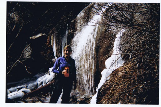
You should not attempt the Mountaineer's Route on Whitney in the wintertime if you are not skilled at route finding and climbing. You should also be in very good physical condition and have time to acclimitize to altitude. It is likely that crampons and an ice axe will be required. You should carry climbing rope, even though you may not need it - some people choose to rope up in the couloir or notch at the top where it gets quite steep. Do not go alone and have a guide or experienced climber in your group. Have a plan but be ready to abandon it if weather conditions are not favorable.
Your climb will start officially at the parking lot at the end of the portal road. Please be advised that the road may be closed in the winter, meaning you can add several miles to your approach if you have to park before the closure and walk in. The road is not plowed and is subject to avalanche and rockfall so if you take your car around the closure (which people do), be aware that you may not get your car back until spring (which is known to happen) or it may be damaged in your absence.
From the portal road, the trail starts on the same path as the main Mount Whitney Trail (called the 'highway' due to the large number of hikers that can be found on it in the summer) but does not follow it for long.
Soon, you will break from the main trail when you see a sign for the North Fork of Lone Pine Creek. After crossing the creek,the trail becomes steep and you follow a valley until the next landmark, the Ebersbacher Ledges. It can be difficult to locate the short chute that you must climb to get up on the ledge (we missed this once when it was snowing).
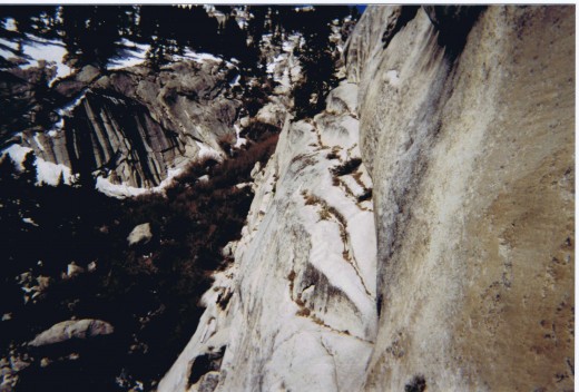
Ebersbacher Ledges to Lower Boy Scout Lake
The guidebook that we used said to look for a lone pine tree on a rock as the marker for the entrance to the ledges. Sounds easy enough, but when you are there, it kind of all looks the same, and it looks different with snow falling too. There are lots of pine trees on the ledge rocks. Once you see "the one", it's more obvious, but we were deceived and took a wrong entrance and had to backtrack a bit. It looks different when it's snowing and you have no path or tracks to follow. Once we found the entrance we knew it was the right one as we had to climb a chute (that we were looking for) to get up onto the ledges. It's not hard climbing (called class 3) but it was higher and steeper than I thought it might be.
The ledges actually have some exposure and can be quite frightening. They are wide enough to walk on, but I could see someone getting hurt if they were fatigued or light-headed from the altitude. There are places where the ledge is barely over a foot wide, with a steep, high cliff on one side and a rock wall on the other side. With a wide pack, you might feel like there isn't much space to maneuver. A lot of people keep a hand on the wall and turn in a bit toward it. Follow the ledges until they end. A trail from there will lead you steeply up to Lower Boy Scout Lake.
Ebersbacher Ledges to Iceberg Lake to (almost) The Summit! (don't know these guys, but good video)
Lower Boy Scout Lake, Upper Boy Scout Lake and Iceberg Lake
Lower Boy Scout Lake is at about 10,400 feet of elevation. If you are doing a multi-day climb and are not acclimitized to altitude, you may decide to spend your first night here to avoid altitude sickness.
From Lower Boy Scout Lake, you will next ascend to Upper Boy Scout Lake about 1000 feet higher at 11,300 feet. Upper Boy Scout Lake is also a good place to camp. If you live at sea level, however and are not an experienced mountaineer, descend to camp at Lower Boy Scout Lake. If you are not acclimitized, you should plan on taking several days for the climb to avoid having to turn back from altitude illness.
If you are acclimitized and are doing the trip in just 2 days (our itinerary), then Iceberg Lake is a great place to camp as it makes the summit climb easier the next day. Be warned, even with mild winter temperatures at lower altitudes, camping at Iceberg Lake is cold. At 11,860 feet, the air is thin and frozen in the winter. The area around the lake is not sheltered and can be quite windy, adding to the discomfort. Try to find a camp site that is at least partially sheltered by a rock. If there are other groups and you are not up there by early evening, you may be out of luck as these spots are rare and coveted.
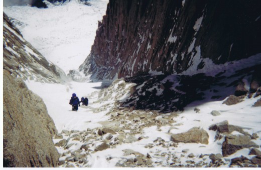
The End of the Climb toward the Summit (this isn't us, but looks similar to our conditions)
Summit Climb on Mount Whitney Mountaineer's Route
From Iceberg Lake, it's pretty easy to see the line to the summit up the East Couloir into the North Chute to the top. Getting there is quite an adventure - too much snow and the steps become slow and painful as you post-hole and expend quite a bit of effort to get one leg in front of the other. Ice is obviously dangerous and fatalities have occurred when a slip was followed by the inability to self-arrest due to ice. No snow, such as during summer, gives you loose scree, sand and talus and can send mini-rock slides to the climbers below and make footing difficult.
The Summit and Descent
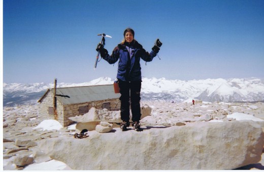
When you get to the top, enjoy the feeling of standing on the highest point in the contiguous United States. The building you see up there was built in the early 1900s for altitude research. Near there is the summit register - make sure to sign it and take some photos. For some reason we took very few photos the entire trip. If I go back, I will be sure to photograph the important landmarks and more on the summit.
As is always true, when you are on the summit, your journey is only half done. For sure, the 6000 foot descent to the portal is less physically strenuous but can be as dangerous if not more so. Many climbers, especially the inexperienced, lose focus. In addition, you are mentally tired and probably haven't slept well in your time on the mountain. The altitude and dehydration can take their toll. You must force yourself to stay alert, take each step carefully and not be too 'sloppy' as you head back down the mountain. The chute, couloir and the ledges require concentration, so before heading into these descents, it's best to take a short rest and drink some water or electrolyte drink and have a snack.
This is not the most difficult mountaineering trail in the U.S. or even California, but it is very satisfying to have done it. Be prepared, be flexible, be strong and be careful!
Me on the Summit of Mt. Whitney
A Few Notes about Our Climb
Month: April
Unsuccessful Attempts: Prior November- turned back at the portal because climbers coming out reported below zero temps and 60 mph winds. Portal road closed which would have added 6 miles to the trip. Went skiing at Mammoth instead.
Rate of Ascent: 1000 vertical feet an hour. Husband trained marines before me and held me to that standard - personal challenge for me achieved. Rest periods as needed.
Conditions: Fresh snow made for some deep postholing and slow going part of the way up the canyon to the ledges and above them. It was snowing lightly with light to moderate winds for our climb.
Pack: 42 pounds, ice axe, crampons, emergency supplies, blister bandages, etc.
Day 1: Portal to Iceberg Lake, got last spot near a rock for some shelter.
Day 2: Iceberg Lake to summit, return to Iceberg Lake, pack up, out to portal. Long day.
Biggest Challenge: Forcing hydration and food. I had no interest in drinking cold fluids in the cold air, but knew it was necessary. Mild nausea made eating and drinking even more difficult. It took too much precious energy to eat snickers bar or protein bar.
Acclimitization: Other lower climbs as training. Spent night before at Bridgeport, CA. Took Diamox (acetazolamide) to help with altitude sickness.
Physical Preparation: Months of running 2-4 miles/day, weight training, stair stepper several times a week, sometimes with a weighted pack.
