- HubPages»
- Travel and Places»
- Visiting North America»
- United States
Family Mini-Vacation to Arkansas, Day Two: Floating the Buffalo River and Visiting Bull Shoals Dam

Will we or won't we float the river?
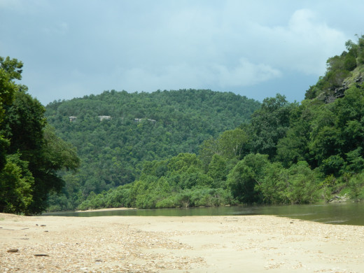
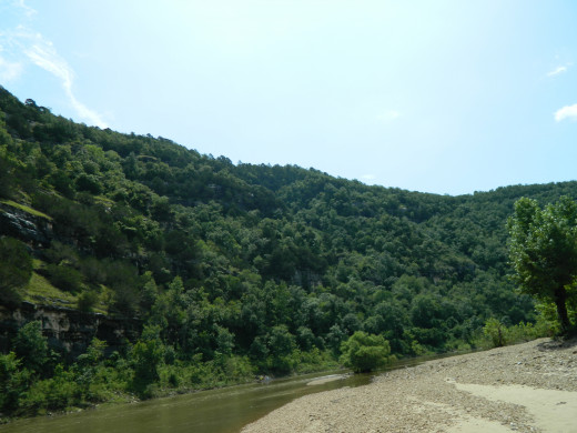
The day dawned cool and cloudy with a chance of rain. Not exactly what one expects on July 3rd, the day before Independence Day. Nor are these conditions the best for floating one of America's wild rivers, the Buffalo River. Named America's first National Wild River in the early 1970's the Buffalo is undammed and untamed for its duration. Almost 140 miles in total length, one can float nearly 135 miles of it depending on what one desires and how the water is running. Judging by what we saw this far downriver, all of it would be able to be floated on this day!
But we had set our sights on the nine mile section between Dillard's Ferry at Highway 14 and Rush, the abandoned "ghost" town downriver. Rush is the final pull out point on the river itself. If you float beyond it you will find yourself with a two day float encompassing close to 25 miles of wild, untamed country.
We really did not want to miss the pull out at Rush.
We decided to give it a go when the meteorologists (what a job to have! Wrong more often than not yet sure of keeping their job!) declared our area rain free until later in the afternoon. We put on our swim trunks and filled a cooler with soft drinks, water and sandwiches and headed out.
We drove the fourteen miles to where our outfitter awaited, then took our car down to our pull out location at Rush. We then boarded the "short bus" (queue the banjos!) and headed off to the put in at Dillard's Ferry. We had brought our own life jackets so a few words of wisdom from our chauffer and we grabbed our cooler and a backpack containing my camera, some snacks and into the canoe we went. I had brought a small folding camp chair so little britches could sit in it in the middle as we floated, but it wasn't too long before he wanted to trade places with his mom and paddle. She agreed to change places with him so we pulled in to the bank after a mile or so and let him man a paddle.
He stayed there the rest of the trip.
We moved surely along the slightly swollen river, and about the only disappointment was the river's color. That it was dirty which could not be helped; there had simply been too much rain of late. The river measured 5.9 at the ferry/bridge. Normally the river runs around 3.5 or so at this time of year so it was around two feet or so high. The outfitter told me that if it had been over 6.0 we would not have been allowed on the river if we were inexperienced. It was my wife's second ever canoe trip; our son's first; and while I have done perhaps twenty or so trips on the river it had been over thirty years since I had been in a canoe. Now, I have never flipped a canoe, nor been in any danger of doing so. Heck, I have been known to stand up and fish while in one and even shot the Clabber Creek Rapids a time or two, but that was when I was young, indestructible and basically stupid. I now knew how much it hurts to get hurt. Wisdom definitely comes with old(er) age.
But we settled in nicely and the float was very pleasant. Oh, it did shower lightly a time or two but the sun shown more often than not. We covered the nine miles in an easy three hours and I did not even get tired of paddling. More importantly, neither did my little man!
He took to this excursion like a duck to water, paddling as if he had done it many times before. A couple of slight corrections early on regarding how to hold the paddle and get the most from the push/pull motion was all it took. His mother took on the role of Sacajawea, directing us here and there as per her whim. We dutifully moved about the river, sightseeing along the way.
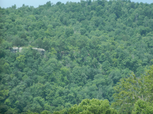
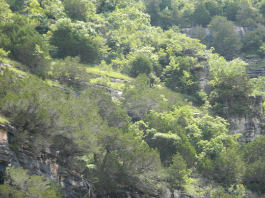
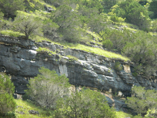
Bluffs soared some five hundred feet into the air along most of the banks, moving from one side to the other dependent upon which way the river moved. Huge, grey-black stones with stunted cedar and pine trees jutting out of the rocks themselves. It is amazing to see how these trees can literally grow on nothing but water, wedged into a crack as a seedling then sprouting into a sapling before continuing their growth over the long years. Roots spread many feet along a bare rock bluff in search of the minerals required to survive and thrive.
Turkey Vultures, better known locally as buzzards soar on the updrafts along the bluffs, rarely ever needing to flap their wings to maintain their height. Here and there little creeks and branches add their input to the river proper as it winds its way downriver to join the White River then on to the mighty Mississippi.
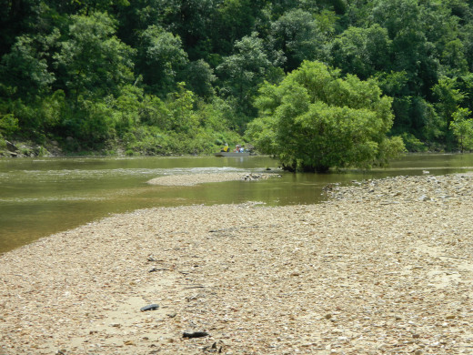
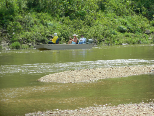
We ran across a boat which had come upriver from Rush. A local guide has his charges in the river boat predominant on the White River and sometimes seen on the Buffalo River and also Crooked Creek. This one has a small outboard motor in order to move against the current up the river, then float back down fishing. I would imagine the target of the day was bass, both Smallmouth and Largemouth. An underappreciated fishery, the Buffalo has a good population of both species. Other fish in the river are Gar, Carp, Catfish and various perch and sunfish.
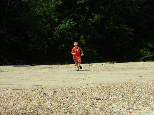
Back to our float: we stopped a couple of times here and there, exploring the banks and sandy shores. Our son even laid claim to a small gravel island and named it after himself, shouting his name time and again across the river and listening to the echo as it returned to him. The smile never left his face. He even wrote his name in the sand for others to see later on.
Turn by turn we moved along the river, them seeing it for the first time, me trying to remember sights from years past. One sight I looked for and was unable to definitely identify was a bluff I used to climb up and walk along. A path was there in the past where one could climb up a couple of hundred feet to a trail which moved along it. There was even a cable set into the face of the cliff at some point in the distant past by an unknown person to facilitate one's movement. I thought I could tell where it was, but trees and undergrowth precluded me from being sure. Ah, well.
All too soon we arrived at our destination. Beaching the canoe and pulling it high on the bank we unloaded our gear and walked towards the car. I did not stop and look back for fear of shedding a tear or two in one of my "moments". Rather I just marched to the car and loaded everything up for the trip back to the motel.

Have you ever canoed a river?
As we drove the road back to join Highway 14 and points north, we spied a Whitetail Deer crossing the road in front of us. We stopped and saw another cross and step into the brush alongside the road. Creeping forward we edged to the spot where they crossed and peered into the brush. Suddenly, our eyes adjusted to the shadows and saw several other deer. As we watched we noticed they were all bucks! All in velvet, they had varying sized antlers on their heads from mere buttons for the yearlings to one that will end up a very respectable ten pointer. Standing broadside to us, contently munching on leaves and grasses as they watched the watchers before ambling off deeper into the underbrush.
Continuing on we came to the abandoned town of Rush, Arkansas. Once a booming mining town with almost 5,000 "citizens" Rush was a boom town for a short period of time in the early 1900's before the mines gave out and virtually everyone moved on to bigger and better things. Late into the 1960's or so a very few hardy souls clung to life here before giving up too. Now the town consists of a few dilapidated buildings, some fencing and a smelter built for the silver one party expected to find here. It was fired up once and never again.
A few trails roam the woods and hills carrying the interested to various locations around the area. Sadly, the mines and caves I explored with friends years ago are now barred and the traveler is not able to explore as we did. One mine had filled with water at some point but the entrance was large enough to drive a large truck into for a ways. Another mine joined this one, with an opening that looked down over the flooded lower level of the larger mine. A cave nearby had several offshoots going various directions and housed bats back in the day. One of the side branches had been hidden for who knew how long until I found it by accident one day. It was accessible only by climbing up the wall about five or six feet and dropping over into another chamber before crawling along a small tunnel another hundred feet or so. I couldn't fit now as it was a close crawl then, with the tunnel being perhaps 18" to 20" in diameter at times before emptying into another large chamber. I never went beyond that and to my knowledge none of my friends ever even knew of it before nor entered it after. Too narrow, I suppose.
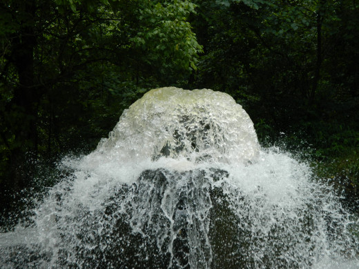
Artesian Spring
Driving north on Highway 14 I remembered something from years ago. Just south of Ralph (the town, not a person) there was a spring that welled up from below ground and shot into the air. Locals would bring empty jugs to the spring and fill them up for personal consumption at home. I struggled to remember which road to turn onto and after a bit I did. Turning west and traveling roughly a half mile down the road we came to the spring.
The water was somewhat dingier than I remembered due no doubt to the rainfall causing higher than normal flow and subsequent higher mineral and sediment particles. But there it was, shooting into the air just as I recalled, the air near the spring significantly cooler than the ambient air beyond its reach. I do not know how many gallons per hour it produces but it must be several thousand gallons, maybe tens of thousands. The opening is roughly twenty-four inches in diameter and the water surges forth nonstop. I have heard that at one time a trout farm existed just downstream if its beginning. I can believe it for the water is cold and highly oxygenated.


We went back to the motel, changed cloths and went swimming after a picnic lunch beside the pool. After a leisurely and enjoyable hour or so, we changed once more and headed up to Bull Shoals Dam. There we toured the Visitor Center overlooking the dam and the White River, and also the river itself immediately below the dam. The water exiting from nearly 200 feet deep above the dam is a crisp 48 degrees F year round and creates a perfect environment for trout. The White River here is a world class fishery featuring Rainbow and Brown Trout as well as Cutthroat, Brook and maybe even a Lake Trout or two. At several times over the years the White held the World Record Brown Trout and still houses some of the largest Brownies one might ever come across.
However, the dam at Bull Shoals has another purpose, that of water control. While Bull Shoals is primarily a reservoir with fishing and recreation at its core, the lake is also built to house and control the water from flooding the lower sections of the river and the Mississippi River. At this time, the dam had been running all seven generators to pull water off the lake but as it is the final dam prior to merging with the Mississippi, the people in charge of the dam must weigh the needs of the area fisherman and those who guide and make their living off the trout and the tourists who come from all over the world with those who live downriver and cannot afford to be flooded, while managing the water level of the lake itself and those who live along its banks. With the lake currently at some thirty one feet above normal and more water coming downstream due to the recent heavy rainfall, I do not envy those who must make those decisions which effect those whose lives are depending on the water. No matter what, someone will be unhappy.


Razorback Ribs
We headed back to the room, trying to decide what we would eat for dinner. Would it be pizza at one of the restaurants in Bull Shoals, Flippin or Yellville? Or perhaps keep it simple and eat at one of the few food chains in the area? In the end, we decided to try some local flavor and went to Razorback Ribs in Yellville.
The reviews were consistent in their wording, almost seeming to have been written by the same people. "Bone sucking good", "Tender and smoky", "Fall of the bone good" were mentioned in virtually every review we read. So, we ordered a full slab, a couple of sides of Mac and Cheese and fries and an order of Deep Fried Pickles.
Yes, you read right. Deep Fried Pickles.
My wife and son LOVE these things. To me, they are ok but nothing I would normally order. For them, anything! So we picked the order up after a short wait and headed back to the room. You see, when I eat ribs I require a couple of things. First, a large amount of napkins. Second, a place to spread out and get comfy. And third (and most importantly) I have to be where I can unbutton my britches. When one eats good ribs, one must allow for expansion of the lower belly region, you know.
And boy, did the reviews ever tell the truth. Tender, fall off the bone, bone sucking goodness abounded in the smoky flavor of these ribs. I am ashamed at how I consumed these ribs (not really). The deep fried pickles were just the right amount of crunch and sour and were the perfect compliment to the ribs.
If you are ever near Yellville you have to eat here. No question about it!
- Razorback Ribs - Barbeque - Yellville, AR - Reviews - Photos - Yelp
10 Reviews of Razorback Ribs "Don't come if you're not hungry! Excellent and very reasonably priced. No kidding, "huge baked potato w/pork and BBQ" was a foot long and 5 6" across and heaping. My BBQ pulled pork plate was terrific. Zucchini fried…


