Travel in South Africa - The Kalahari Desert


Semi-deserts in South Africa
A very large part of South Africa has a cold semi-arid climate.
A semi-arid climate receives rain below potential rainfall. While rainfall in a true desert is too low to sustain any vegetation at all, semi-arid climates support short/scrubby vegetation such as grasses, shrubs and drought-resistant trees. It also support a very large variety of animals.
Temperatures in summer are hot to extremely hot, and during winters, cold to extremely cold. Extremely hot in South Africa would be 40°C (104 °F) and up, while -4 °C (24.8 °F) is considered to be extremely cold. Midwinter temperatures in Sutherland - the coldest town in SA - can be as low as −15 °C (5 °F) during mid-winter.
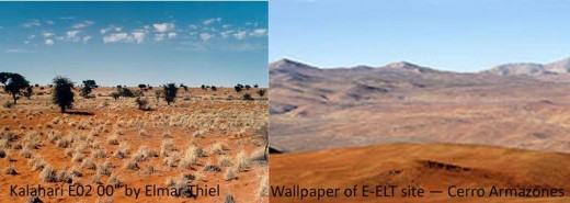
Semi-arid climate (left) versus arid climate (right)
Semi-arid climates can be hot or cold. Some differences between hot and cold semi-arid climates:
HOT SEMI-ARID
| COLD SEMI-ARID
|
|---|---|
Type: type BSh
| Type: BSk
|
Located in the tropics and subtropics.
| Located in temperate zones.
|
Climates tend to have hot, sometimes extremely hot, summers and mild to warm winters.
| Climates feature hot and dry, often exceptionally hot, summers, though typically not as hot as those of hot semi-arid climates. Winters are cold.
|
Snow falls rarely , if ever.
| Some snowfall during winters.
|
Most commonly found around the fringes of subtropical deserts.
| Subjected to major temperature swings between day and night, sometimes by as much as 20 °C (36 °F) or more in that time frame.
|
Experiences the seasonal effects of monsoons and has a short but well-defined wet season, but is not sufficiently wet overall to qualify as a tropical savanna climate.
| Cold semi-arid climates at higher latitudes tend to have dry winters and wetter summers, while cold semi-arid climates at lower latitudes tend to have precipitation patterns more akin to Mediterranean climates, with dry summers, relatively wet winters, and even wetter springs and autumns.
|
Found in regions such as West Africa, India, parts of Mexico and bordering areas in Texas, parts of Southern California, and small parts of Pakistan.
| Found in Asia and North America. However, they can also be found in Northern Africa, South Africa, Europe (primarily in Spain), sections of South America and sections of interior southern Australia and New Zealand.
|
wikipedia.org/wiki/Semi-arid_climate
Two regions in South Africa have COLD SEMI-ARID climates - the Kalahari Desert and the Karoo -

The Kalahari Desert extends over South Africa, Namibia, Botswana, Zimbabwe, Zambia, Angola, Congo and Burundi.
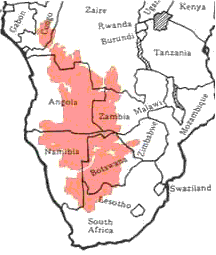
The Kalahari Desert in South Africa
The size of the Kalahari Desert is 930,000 km2 (359,075 sq mi). Only a very small part of it falls in South Africa. Although it has patches of arid-climates, it is mainly cold-semi-arid.
Some interesting facts about the Kalahari Desert -
- According to scientific evidence the Kalahari came into existence approximately sixty million years ago.
- Until about 10,000 years ago the Kalahari was a much wetter place, still evident in huge subterranean water reserves beneath parts of it, like the Dragon's Breath Cave in Namibia, which is the largest documented non-subglacial underground lake on the planet.
- The word ‘kalahari’ derived from the San word ‘kgalagadi, meaning "a waterless place".
- Although daily temperatures occasionally reach up to 45°C (113°F), the average temperature of the warmest month in any region of the Kalahari seldom, if ever, exceeds 29°C (84.2°F). During mid-winter the average temperature can drop to ± 6°C (42.8°F). The average temperature of the warmest month in a true desert like the Sahara is 38°C (100.4°F).
- The driest areas in the Kalahari receive ±50mm–200 millimetres (1.9–7.9 in) rain per year, all of it during summer. However, some areas in Botswana are seasonal wetlands, receiving more than 500 mm rain per year. Also in South Africa is a region called the Green Kalahari, where the longest river in South Africa, the Orange River, and/or a fountain, provide sufficient water to support dense vegetation.
- Beneath the surface of the Kalahari lies an amazing wealth of iron, zinc, diamonds, lead, copper, silver, and manganese. (Manganese is a hard brittle grey polyvalent metallic element that resembles iron but is not magnetic; used in making steel. It occurs in many minerals.)
- Typical characteristics of the Kalahari are its vast open spaces, red, sandy soil, countless nests of sociable weavers (Philetairus socius) on telephone poles, Camel Thorn and quiver trees (Aloe dichotoma), low growing bushes, shrubs, succulents, windmills, sheep and ostriches, and wild animals in game reserves.
The Green Kalahari
The Green Kalahari is the region that extends for hundreds of kilometers along the Orange River (Gariep River) - the longest river in South Africa. It has many fertile plains, flanked by vineyards. Situated in the Green Kalahari are among others Upington, the town hosting South Africa's largest wine co-operative, The Orange River Wine Cellars, the Augrabies waterfalls (inside the Augrabies Falls National Park), the Spitskop Nature Reserve (just outside Upington), the Kgalagadi Transfrontier Park, and also the towns Olifantshoek and Kuruman. As in Namaqualand and The-West-Coast, the sandy flats of the Green Kalahari turn into carpets of wild flowers after the first summer rains in August/September.
A road-trip through the Kalahari Desert -


. Due to the lack of trees they build their nests on telephone poles,")

, Tswalu Kalahari Reserve, South Africa")


")

Game Reserves situated in the Kalahari, South Africa
The Kalahari Desert accommodates thousands of wild animals in game reserves. The following game reserves are situated in the Northern Cape Province, South Africa -
- The Tswalu Kalahari Game Reserve – the largest private game reserve in Southern Africa, owned by the Oppenheimer family. Surrounded by the rugged Koranneberg Mountains, it covers 1000km2 (100 000 ha) of land. Tswalu means “New Beginning”. It is situated in the Northern Cape Province - the historical home of the San People, the original inhabitants of South Africa.
- The Kgalagadi Transfrontier Park - Approximately 250 km from Upington in the far Northern Cape it straddles the border between South Africa and Botswana. It comprises two adjoining national parks – The Kalahari Gemsbok National Park in South Africa and the Gemsbok National Park in Botswana. The total area of the park is 38,000 square kilometres (15,000 sq mi)
- The Witsand Nature Reserve – This reserve's famous ‘roaring dunes’ attract tourists from all over the world. Those sand dunes emit a strange rumbling sound when disturbed.
- Spitskop Nature Reserve and the Augrabies Falls National Park – are situated in the Green Kalahari on the banks of the Orange River just outside Upington.
- And more!
Tswalu Kalahari
Kalahari & Kgalagadi Transfrontier Nationalpark
The original inhabitants of the Kalahari
For 20,000 years The Kalahari was the home ground of the San people - the world's most ancient people. They ate edible plants, insects and wild game, which they hunt with bows and poison arrows. They got most of their water from plant roots and desert melons, and used to store water in blown-out shells of ostrich eggs. They lived in huts built from local materials such as branches and grass. Infiltration of Africans, mostly Herero- and Tswana people, and Europeans, began in the 17th century.
San children

Towns in the Kalahari Desert, South Africa
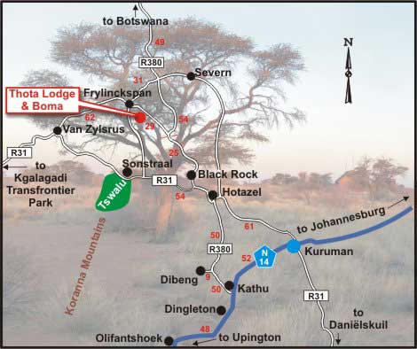
Some of the towns in the Kalahari Desert, South Africa
The Kalahari Desert in South Africa is situated in the Northern Cape Province. A number of towns have been established since 1821. Just to mention a few -
- Black Rock - 25 km from Hotazel. Gaydefroyite, Sturmanite, and Xonotlite are only some of the minerals being mined in the Kalahari Manganese Field. This field contains around 80% of the world's high-grade manganese ore reserves.
- Dibeng - meaning "first drinking place". Dibeng was originally a farm until a Dutch Reformed church was establish on 15 May 1909 to serve the farmers in the region. Situated on the banks of the dry Gamagara River, almost every house in this town has a windmill pumping water to the surface.
- Kathu - meaning 'the town under the trees', as it is situated in the middle of a Camel Thorn tree (Vachellia erioloba) forest. This forest, approximately 4000 hectares in size, is one of only two of its kind in the world. Kathu, founded in the late 1960's, is the iron ore capital of the Northern Cape province. It has one of the five largest open-cast iron ore mining operations in the world.
- Van-Zylsrus - serving the most prosperous game ranches in the region.
- Hotazel - hot as hell, indeed. However, at 37°C (98.6°F) on the top end of the scale and 3°C (37.4°F) at the bottom, it is not the hottest place in the Kalahari. The town was established on a farm named Hotazel, to serve the manganese mines in the region.
- Dingleton and Sishen, was founded in 1953 to accommodate miners.
- Olifantshoek, founded in 1912 at the foot of the spectacular Lange Mountains, was originally a police post. Because many elephant bones were found in the vicinity, indicating the existence of an elephant graveyard, and the tusk of an elephant was used as payment for the farm on which the town was built, the town was called Olifantshoek (Elephant's corner). The Kalahari’s famous white ‘roaring dunes’, over 100 m high and 10 km long, is right here, protected in the Witsand Nature Reserve.


, Northern Cape Province, South Africa")


Kuruman
Kuruman, the main town of the Kalahari Desert, is known as the "oasis of the Kalahari". It has a permanent and abundant source of water – a mineral spring called the Eye of Kuruman. This spring is situated in the middle of the town and delivers 20 million litres (5 283 441 US gallons) of pristine water a day.
Like most of the towns in the Kalahari, Kuruman serves and accommodates miners. The richest deposits of crocidolite (a type of asbestos) in the world are found here. The town was named after the Kuruman River – a dry river except for floods after heavy rains.
Kuruman was founded in 1821 by the Scottish missionary, Robert Moffat, founder of Christianity and the Moffat church in South Africa. Moffat lived in Kuruman from 1820-1870 (50 years), and translated and printed the Bible in Setswana. His journals and letters are a precious recourse used by historians. He was a friend of Mzilikazi, the founder of the Matabele kingdom in Matabeleland-Rhodesia-Zimbabwe. David Livingstone, who also lived in Kuruman, referred in his autobiography to Mzilikazi as the second most impressive African leader after Shaka.
The Eye of Kuruman


Back to Kuruman's beauty!


Upington and the Augrabies Falls
My photo tour of Upington and the Augrabies Falls will be published soon.
Related

The Eye of the Groot Marico River, South Africa

The San Bushmen of the Kalahari Desert and Hoodia Gordonii

Start Your Visit to Kwa-Zulu Natal South Africa By Checking in at These Landmarks
 - The Khoi People")
The Khoisan People of Southern Africa (Part One) - The Khoi People

Indians in South Africa – 150 years of toil and triumph


