South Island - New Zealand

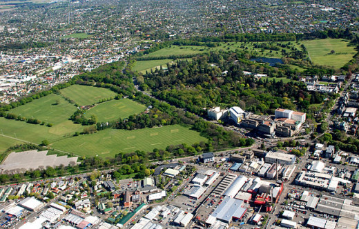
Hagley Park, Christchurch, South Island, New Zealand
Christchurch My Dream Vacation.
Some 12 years ago I was planning a holiday in the South Island of New Zealand it was a dream I was looking forward to, I had started planning it, even brought the road maps and was looking for accommodation, now August 2014 my dream is coming true I have started working on ideas and plans to make the trip come true as my GrandDaughter and Grandson-in-law are farming in Ashburton which isn't far from Christchurch.
The reason I put it off, earthquakes February 2011, Christchurch beautiful buildings like the Cathedral, which I was looking forward to visiting, has been destroyed, sad.
New Zealand Herald - 4 days ago - 29 October 2011. The quake-crippled Christ Church Cathedral will be partially demolished with its remains incorporated into a modern new cathedral.
One of the main reason why I was going down south was because it was where William Hagley my husbands Great Grandfather arrived on the Sebastopol, at Lyttelton on 14 December 1861.
He died on 19 August 1879 age 44. buried at Balcairn Public Cemetery - but it has no headstone.
I was planning a holiday traveling around the South Island, while doing that, stopping off and erecting a plaque in his memory.
Taking a walk around Hagley Park and along the beautiful Avon River, which I will still be doing.
A little About Hagley Park is the largest urban open space (164.637 hectares) in Christchurch, New Zealand and was created in 1855 by the Provincial Government.
Hagley Park is characterized by its trees and broad open spaces it was named after the country estate of Lord Lyttelton, who became chairman of the Canterbury Association in March 1850.
The boundaries of the park, which is located in the central city of Christchurch, are defined by both the Avon River and the surrounding roadways.
I'm sharing some beautiful photos of the South Island New Zealand with you, maybe one day you will have a dream of a vacation in the South Island of New Zealand and make the trip yourself.
New Zealand's South Island: A Road Trip
South Island of New Zealand
New Zealand is a beautiful place, if planning a holiday, allow time, as there is so much to see.
Christchurch seems to have settled now from all those earthquakes, so looking forward to that dream vacation in South Island of New Zealand.
There is so much to be seen here in this "Land of the Long White Cloud" but I believe, that right here in the South Island, it is the eye of nature, sight's you will only see in New Zealand, beyond anything you can imagine.
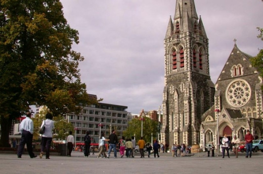
Beautiful Christchurch Cathedral Square before the Earthquake
Christchurch is the regional capital of Canterbury, New Zealand.
The largest city in the South Island, it is also the second largest city and third largest urban area of New Zealand.
A coastal city, the urban area is situated just north of Banks Peninsula, midway down the South Island's east coast.
The river which flows through the centre of the city (its banks now largely forming an urban park) was named Avon at the request of the pioneering Deans brothers to commemorate the Scottish Avon, which rises in the Ayrshire hills near what was their grandfathers' farm and flows into the Clyde.
On 6 March 2004, the area administered by the Christchurch City Council had a population of 344,100, making it the second-largest in New Zealand, and the largest city in the South Island.
Pyne Gould Building Destroyed By EarthQuake
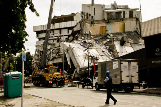
The collapsed Pyne Gould Building. Thirty of the building's two hundred workers were trapped within the building following the February earthquake.
An earthquake with magnitude 7.1 occurred near Christchurch at 4:35 am local time, 4 September 2010
The earthquake occurred at a depth of 10 kilometres (6.2 mi), and despite widespread damage there were no fatalities.
A large aftershock of magnitude 6.3 occurred on 22 February 2011 at 12:51 pm.
It was centred just to the north of Lyttelton, 10 kilometres south-east of Christchurch, at a depth of 5 km.
The quake struck on a busy weekday afternoon and resulted in the deaths of 181 people.
This event resulted in the declaration of New Zealand's first National State of Emergency.
Many buildings and landmarks were severely damaged, including the iconic 'Shag Rock' and Christchurch Cathedral.
On 13 June 2011 Christchurch was again rocked by two more large aftershocks.
A 5.6 at only 9 km (6 mi) deep hit at 1.00pm in the general location of Sumner, Christchurch this was followed by another 6.3 at only 6 km (4 mi) deep at 2.20pm again.
This resulted in more liquefaction and building damage, but there were no deaths.
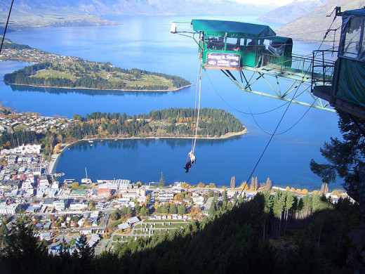
Bungy jumping in Queenstown South Island NZ.
If You Visited New Zealand - Would You Visit Christchurch.
Satellite View of the South Island
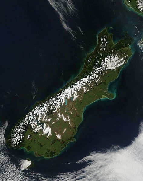
The South Island is the larger of the two major islands of New Zealand, the other being the more populous North Island.
It is bordered to the north by Cook Strait, to the west by the Tasman Sea, to the south and east by the Pacific Ocean.
The territory of the South Island covers 151,215 square kilometres (58,384 square miles) and is influenced by a temperate climate.
The South Island is sometimes called the "Mainland". While it has a 33% larger landmass than the North Island, only 24% of New Zealand's 4.4 million inhabitants live in the South Island.
In the early stages of European settlement of the country, the South Island had the majority of the European population and wealth due to the 1860s gold rushes.
The North Island population overtook the South in the early 20th century, with 56% of the population living in the North in 1911, and the drift north of people and businesses continued throughout the century.
Spring in Esk Street, one of the main shopping streets of Invercargill
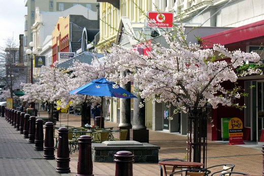
Invercargill NZ - My Dream Further South
I think when we leave Christchurch we will travel further south to view the beautiful landscape as far as the eye can see. Esk Street, one of the main shopping streets of Invercargill.
Invercargill is the southernmost and westernmost city in New Zealand, and one of the southernmost settlements in the world. It is the commercial center of the Southland region. It lies in the heart of the wide expanse of the Southland Plains on the Oreti or New River some 18 km north of Bluff, which is the southernmost town in the South Island.
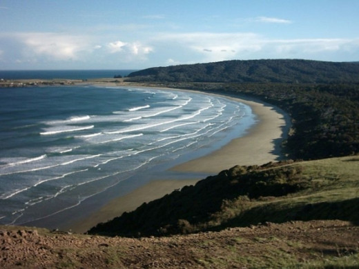
It sits amid rich farmland that is bordered by large areas of conservation land and marine reserves, including Fiordland National Park covering the southwest corner of the South Island.
A Southland Beach - Invercargill
The average temperature high ranges from 18.c in January to 11.c in August.
Owing to its relatively high latitude, the city enjoys nearly 16 hours of daylight at the summer solstice in late December.
Invercargill has a temperate oceanic climate similar to that of the British Isles.
The mean daily temperature ranges from 5.c in July to 14.c in January. The yearly mean temperature is 9.c Rainfall averages 1112 mm, annually, and measurable snowfall is occasionally seen during the winter months of June to September.
It is the cloudiest centre of New Zealand with 1580 hours of sun shine per annum.
Milford Track River - Southland
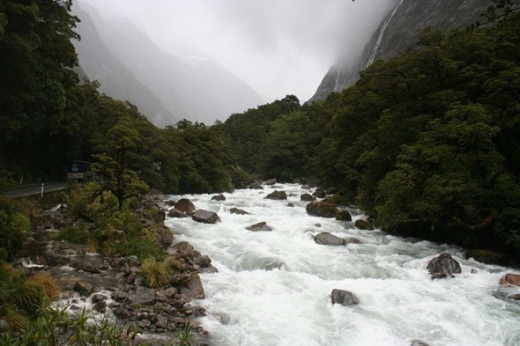
The Milford Track is New Zealand's most famous tramping route and is one of the most famous walking tracks in the world.
It is located in stunning scenery amidst mountains and temperate rain forest in Fiordland National Park in the southwest of the South Island.
Mount Cook from Hooker Valley
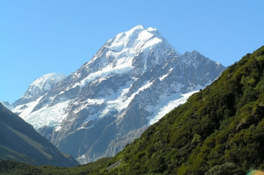
Mount Cook is the highest mountain in New Zealand.
It lies in the Southern Alps, the mountain range which runs the length of the South Island. A popular tourist destination, it is also a favourite challenge for mountain climbers.
Mt Cook consists of three summits lying slightly south and east of the main divide, the Low Peak, Middle Peak and High Peak, with the Tasman Glacier to the east and the Hooker Glacier to the west.
The Southern Alps is a mountain range which runs along the western side of the South Island of New Zealand.
It forms a natural dividing range along the entire length of the South Island.
The term "Southern Alps" generally refers to the entire range, although separate names are given to many of the smaller ranges that form part of it.
Aoraki Mount Cook
From an intrepid journey through glacial valleys to a mouth-watering culinary dining adventure.
The Hermitage Hotel is the perfect 'base camp' to discover your Peak Experience.
Choose from premium hotel rooms, motel units or cozy chalets.
Add world-class activities such as Glacier Explorers, Tasman Valley 4WD and Argo Tours, scenic flights or the visual extravaganza of the Sir Edmund Hillary Alpine Centre and you have a unique, year-round alpine adventure perfect for the family holiday or your next romantic getaway.
Mount Cook From Tekapo Canal
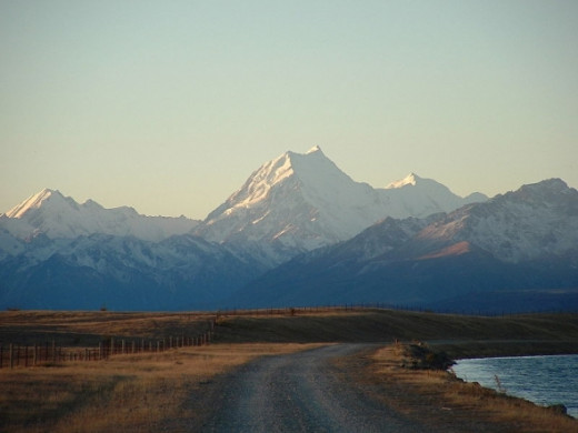
Mt Cook at Dusk viewed from the Tekapo Canal
Mount Cook is the highest point, 3754 metres (12,283 feet).
There are 16 other points in the range that exceed 3,000 metres in height.
A large proportion of the range is protected as part of various national parks, notably the Westland National Park, Mount Aspiring National Park, and Mount Cook National Park.
The Southern Alps contain some 360 glaciers, the largest of which - the Tasman Glacier - is 29 kilometres in length.
Lake Marian in Fiordland
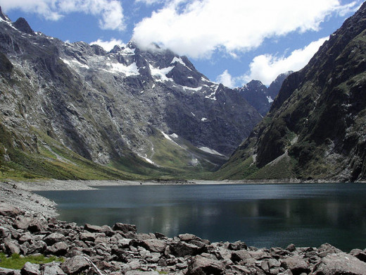
Lake Marian in Fiordland National Park near the Homer Tunnel on the road to Milford Sound.
Fiordland is a geographic region of New Zealand that is situated on the south-western corner of the South Island.
Most of it is covered by the Fiordland National Park, which has an area of 12,120 square kilometres, making it the largest national park in New Zealand and one of the larger parks in the world, containing many famous tramping tracks.
Most of Fiordland is dominated by the Southern Alps and its ocean-flooded, steep western valleys.
Situated within Fiordland are Browne Falls and Sutherland Falls, which rank among the tallest waterfalls in the world.
The name "Fiordland" comes from the now-common variant of the Norwegian word "fjord".
Fiordland features a number of fiords (often misnamed sounds), of which Milford Sound is the most famous, though Doubtful Sound is even larger and has more and longer branches (but is also more inaccessible).
Lewis Pass
Lewis Pass (el. 864 m.) is a mountain pass in the South Island of New Zealand.
The northernmost of the three main passes across the Southern Alps, it is higher than the Haast Pass, but slightly lower than Arthur's Pass.
State Highway 7 traverses the pass on its route between north Canterbury and the West Coast; it passes through extensive unmodified beech forest.
The pass is the saddle between the valleys of the Maruia River to the north west and the Lewis River to the southeast.
The saddle is located close to the small spa of Maruia Springs.
There are a number of tramping routes in the Lewis Pass area, including the St James Walkway.
Franz Josef Glacier
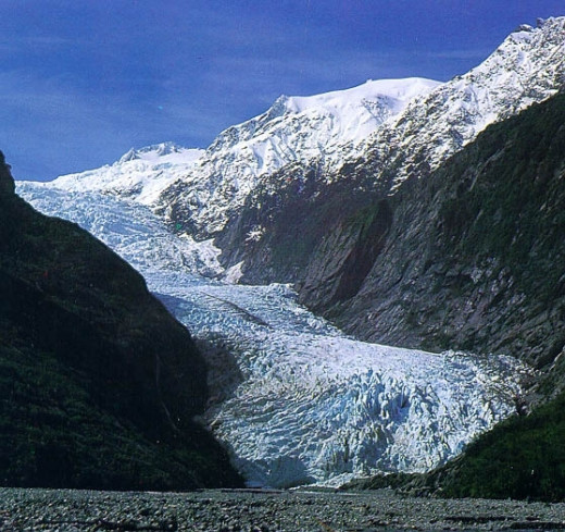
Franz Josef township is a little service village (approximately 330 inhabitants) located approximately 5 km away from the face of the glacier on State Highway 6.
It has a small but busy heliport, numerous tourist accommodation options (with up to 2,000 people staying overnight during the main season) and a number of restaurants and shops.
The glacier area is one of the main tourist attractions of the West Coast, with around 250,000 visitors a year, and up to 2,700 per day (2007).
Guided and unguided walks up to and onto the glacier are possible.
The latter require some specialised equipment, namely ice axes and crampons that latch onto a sturdy boot.
Queenstown Mall
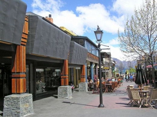
Queenstown is a resort town in Otago in the south-west of New Zealand's South Island.
It is built around an inlet on Lake Wakatipu, a long thin lake shaped like a staggered lightning bolt, and has spectactular views of nearby mountains.
Its neighbouring towns and districts include Arrowtown, Wanaka, Alexandra, and Cromwell.
The nearest cities are Dunedin and Invercargill.
The Queenstown-Lakes District has a land area of 8,704.97 km (3,361.01 sq miles) not counting its inland lakes (Lake Hawea, Lake Wakatipu, and Lake Wanaka).
Queenstown And Remarkable Mountains
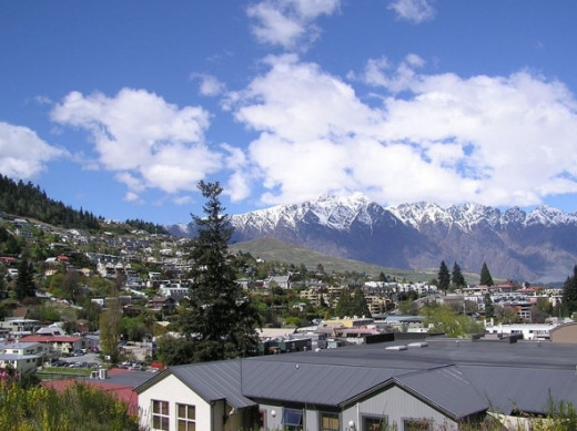
Lake Wakatipu is renowned for its scenic beauty, being surrounded by mountains.
The Remarkables mountain range lies along its southeastern edge.
It is a popular venue for adventure tourism, with skifields, paragliding, bungy jumping and tramping tracks within easy reach.
Lake Whakatipu - Queenstown
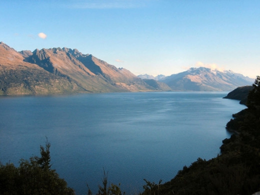
Lake Wakatipu is an inland lake (finger lake) in the South Island of New Zealand.
It is in the southwest corner of Otago Region, near its boundary with Southland.
With a length of 80 kilometres, it is New Zealand's longest lake, and, at 291 km, its third largest. It is at an altitude of 310 metres, towards the southern end of the Southern Alps.
Milford Sound - Stirling Falls
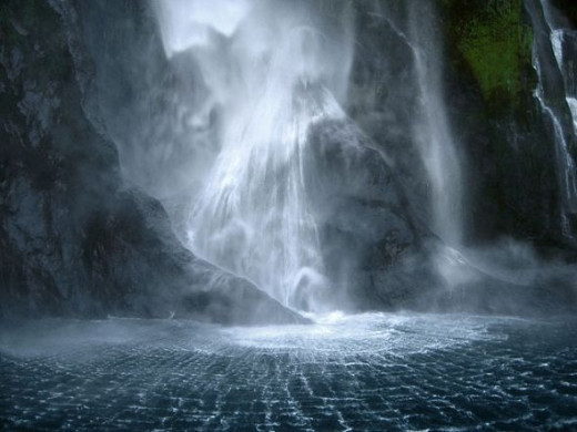
Milford Sound is a fiord in the south west of New Zealand's South Island, within Fiordland National Park.
It has been judged the world's top travel destination in an international survey (the 2008 Travelers' Choice Destinations Awards by TripAdvisor) and is acclaimed as New Zealand's most famous tourist destination. Rudyard Kipling had previously called it the eighth Wonder of the World.
© 2011 Elsie Hagley


