ArtsAutosBooksBusinessEducationEntertainmentFamilyFashionFoodGamesGenderHealthHolidaysHomeHubPagesPersonal FinancePetsPoliticsReligionSportsTechnologyTravel

Digital Elevation Models and Methods for Representing the Surface of the Earth

Updated on October 4, 2012
CWanamaker profile image

Chris is a registered professional civil engineer and has worked on a more than 300 public and private projects over the last decade.

This digital elevation model of the El Misti Volcano in Peru was created using remote sensing techniques.
This digital elevation model of the El Misti Volcano in Peru was created using remote sensing techniques. | Source

Many of today's GIS technologies and analytical methods rely on an accurate base of elevation data to create reliable results. Whether you're predicting future weather patterns, the probable spread of a wildfire, or computing floodplain hydraulics, a good digital elevation model is always a key component of your analysis. So what are digital elevation models, how do they function, and what methods are used to capture the information they represent?

What are Digital Elevation Models (DEMs)?

Digital elevation models are computer representations of the surface of the earth. A true DEM affords the user the ability to obtain elevation information continuously at any point in the data. DEM’s are divided into two subcategories known as Digital Terrain Models (DTM) and Digital Surface Models (DSM).

A DSM is typically raw or slightly processed elevation information about the earth’s surface. The data represents all of the surfaces that can be seen from the sky. This includes the top elevations of all the plants and buildings on the ground . Because of this, DSMs are generally cheaper to obtain and really only have some limited practical uses.
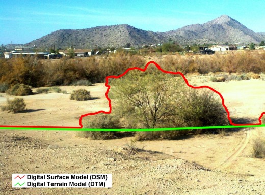
This image shows the difference between a DSM (red line) and a DTM (green line).
This image shows the difference between a DSM (red line) and a DTM (green line). | Source

Digital terrain models are sets of data that represent the earths bare ground surface. All of the buildings, trees, and other structures are removed from data. Often times DTMs are created by executing complex computer algorithms to remove structures, vegetation and other anomalies. However this process has not been perfected and often times there can be errors in the accuracy of the elevation information. Care should be taken by the end user if a DTM has been created using these methods. The best DTMs are created using a combination of remote sensing techniques and manual (human) quality control. This also makes them more expensive to purchase.

How are DEMs Stored and Represented?

There are two main ways that digital elevation models are stored and represented in a GIS environment. The first method is a raster format. Rasters can store data in a grid pattern. The grid is formed by rows and columns of pixels. Each pixel represents the location and elevation of that particular spot on the ground. The width of the pixel represents the accuracy of the elevation model. There are two big advantages of rasters: 1) they enable you to have continuous and accurate data and 2) they can be easily converted to any other data format such as TINs and contour lines. The disadvantage of raster formats is that they tend to require large amounts of disk space and can significantly slow down some of the analytical computations in a GIS application.

The second way that DEMs can be stored and represented is through a triangulated irregular network or TIN. TINs are made of a series of triangles whose vertices represent three dimensional coordinates of the earth’s surface. The vertices, or nodes, are joined together by lines that form the edges of the triangles. TINs are great because they are easy to work with and don’t require a lot of disk space.
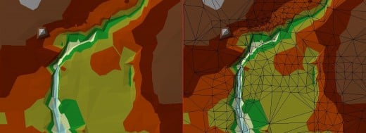
The image on the left is an illuminated and colorized TIN. The image on the right is the same TIN except that the edges of the triangles are highlighted.
The image on the left is an illuminated and colorized TIN. The image on the right is the same TIN except that the edges of the triangles are highlighted. | Source

How are DEMs Created in the First Place?

There are actually quite a bit of methods by which the data needed to create DEMs are acquired. Because this can be quite a lengthy discussion as it is, I will only focus on the three most common DEM creations methods.

Photogrammetry – This is one of the oldest methods for generating large amounts of accurate elevation data. Much like having a pair eyes can allow us to perceive distance and depth, multiple aerial photographs can be analyzed and transformed into a three dimensional surface. Before LIDAR was invented, this was the most common method used to creating DEMs.

LIDAR – LIDAR stands for Light Detection and Ranging and works in a similar fashion that typical RADAR and SONAR devices do. Airplanes flying above the ground utilize LIDAR technology to determine surface profiles by calculating how long it takes light energy to travel to and from the device. After the flight is complete, the data undergoes post-processing where it is edited and converted to a useable file format.

Ground Survey – Ground elevation surveying using GPS and theodolites will probably give you the most accurate representation of the earth’s surface out of any other available method. The major downside to this method of DEM creation is that it is very expensive and requires a lot of time to complete. It also cannot practically be done on a large scale. As a side note, ground survey methods typically do not result in a continuous set of data, thus, they result is not a true digital elevation model.

working

This website uses cookies

As a user in the EEA, your approval is needed on a few things. To provide a better website experience, hubpages.com uses cookies (and other similar technologies) and may collect, process, and share personal data. Please choose which areas of our service you consent to our doing so.

For more information on managing or withdrawing consents and how we handle data, visit our Privacy Policy at: https://corp.maven.io/privacy-policy

Show Details
Necessary
HubPages Device IDThis is used to identify particular browsers or devices when the access the service, and is used for security reasons.
LoginThis is necessary to sign in to the HubPages Service.
Google RecaptchaThis is used to prevent bots and spam. (Privacy Policy)
AkismetThis is used to detect comment spam. (Privacy Policy)
HubPages Google AnalyticsThis is used to provide data on traffic to our website, all personally identifyable data is anonymized. (Privacy Policy)
HubPages Traffic PixelThis is used to collect data on traffic to articles and other pages on our site. Unless you are signed in to a HubPages account, all personally identifiable information is anonymized.
Amazon Web ServicesThis is a cloud services platform that we used to host our service. (Privacy Policy)
CloudflareThis is a cloud CDN service that we use to efficiently deliver files required for our service to operate such as javascript, cascading style sheets, images, and videos. (Privacy Policy)
Google Hosted LibrariesJavascript software libraries such as jQuery are loaded at endpoints on the googleapis.com or gstatic.com domains, for performance and efficiency reasons. (Privacy Policy)
Features
Google Custom SearchThis is feature allows you to search the site. (Privacy Policy)
Google MapsSome articles have Google Maps embedded in them. (Privacy Policy)
Google ChartsThis is used to display charts and graphs on articles and the author center. (Privacy Policy)
Google AdSense Host APIThis service allows you to sign up for or associate a Google AdSense account with HubPages, so that you can earn money from ads on your articles. No data is shared unless you engage with this feature. (Privacy Policy)
Google YouTubeSome articles have YouTube videos embedded in them. (Privacy Policy)
VimeoSome articles have Vimeo videos embedded in them. (Privacy Policy)
PaypalThis is used for a registered author who enrolls in the HubPages Earnings program and requests to be paid via PayPal. No data is shared with Paypal unless you engage with this feature. (Privacy Policy)
Facebook LoginYou can use this to streamline signing up for, or signing in to your Hubpages account. No data is shared with Facebook unless you engage with this feature. (Privacy Policy)
MavenThis supports the Maven widget and search functionality. (Privacy Policy)
Marketing
Google AdSenseThis is an ad network. (Privacy Policy)
Google DoubleClickGoogle provides ad serving technology and runs an ad network. (Privacy Policy)
Index ExchangeThis is an ad network. (Privacy Policy)
SovrnThis is an ad network. (Privacy Policy)
Facebook AdsThis is an ad network. (Privacy Policy)
Amazon Unified Ad MarketplaceThis is an ad network. (Privacy Policy)
AppNexusThis is an ad network. (Privacy Policy)
OpenxThis is an ad network. (Privacy Policy)
Rubicon ProjectThis is an ad network. (Privacy Policy)
TripleLiftThis is an ad network. (Privacy Policy)
Say MediaWe partner with Say Media to deliver ad campaigns on our sites. (Privacy Policy)
Remarketing PixelsWe may use remarketing pixels from advertising networks such as Google AdWords, Bing Ads, and Facebook in order to advertise the HubPages Service to people that have visited our sites.
Conversion Tracking PixelsWe may use conversion tracking pixels from advertising networks such as Google AdWords, Bing Ads, and Facebook in order to identify when an advertisement has successfully resulted in the desired action, such as signing up for the HubPages Service or publishing an article on the HubPages Service.
Statistics
Author Google AnalyticsThis is used to provide traffic data and reports to the authors of articles on the HubPages Service. (Privacy Policy)
ComscoreComScore is a media measurement and analytics company providing marketing data and analytics to enterprises, media and advertising agencies, and publishers. Non-consent will result in ComScore only processing obfuscated personal data. (Privacy Policy)
Amazon Tracking PixelSome articles display amazon products as part of the Amazon Affiliate program, this pixel provides traffic statistics for those products (Privacy Policy)
ClickscoThis is a data management platform studying reader behavior (Privacy Policy)