Everything you wanted to know about terrestrial globes but were afraid to ask

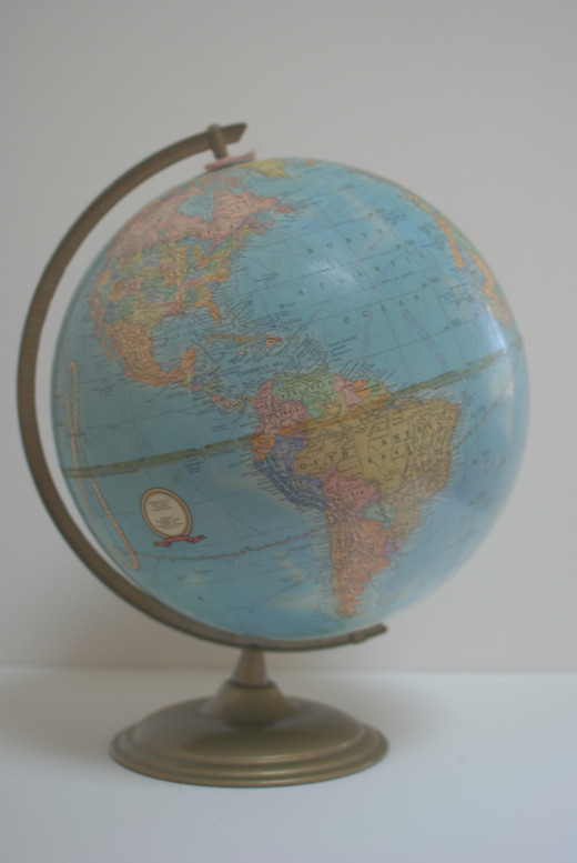
Terrestrial globes are simply 3-dimensional scales of Earth that may be smooth or textured to illustrate the topography of the planet. A celestial globe, on the other hand, depicts the imaginary sphere that encompasses Earth and the celestial bodies that surround it.

Who invented the terrestrial globe?
Many students were taught that before Columbus discovered America Europeans believed that the Earth was flat. That was incorrect. The Ancient Greeks were aware that the Earth was round based on three observations. Aristotle observed that gravity forces particles to “form themselves about the middle and make a sphere”. There was also the presence of the Earth’s shadow during an eclipse of the moon. Finally, the ancients surmised that the Earth was round because far away objects appear to be above the horizon as they were approached.
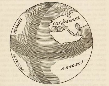
Crates of Mallos, a member of the Stoic School of Philosophers, appears to be the first person to create a terrestrial globe to depict the Earth in approximately 150 BC. Crates believed that the planet was divided into four quadrants which included 4 habitable regions: the Oecumene, the Perioeci, the Antoeci, and the Antipodes. The Oecumene (Ecumene) described the inhabitable world in the northeast quadrant. The Perioeci means the same latitude, other side. The Antoeci was opposite the Perioeci and the Antipodes was diagonal to the Oecumene.
This knowledge was not widely taught during the Dark Ages due to objections from religious leaders . Thus, no terrestrial globes survived antiquity or the Middle Ages.
According to the Guinness Book of World Records, the oldest surviving terrestrial globe in the world is the Erdapfel by German merchant Martin Behaim. The Erdapfel (1492) is considered one of the first modern terrestrial globes and it was commissioned by the city council of Numberg to commemorate the recent discoveries.
The Erdapfel included:
- A scale of 1:25,138,000
- An equator divided into 360 degrees
- The Tropics
- The Arctic and Antarctic circles
- A single meridian drawn 80 degrees to the west of Portugal
The Erdapfel did not include:
- The Americas as Columbus did not return to Europe until 1493


Globe Terminology
Consider the following terms when using a globe.
Equator
The equator is an imaginary line that runs from east to west in the exact middle of the Earth.
Prime Meridian
The prime meridian is an imaginary line that runs north to south through Greenwich, England. (It should be noted that this is the historical prime meridian agreed to by international conference in 1884.)
Zero Point
The zero point is the point at which the equator and prime meridian intersect. This point is located in the Gulf of Guinea in the Atlantic Ocean.
Latitude
The latitude is an imaginary line that runs parallel to the equator.
Longitude
The longitude is an imaginary line that runs from pole to pole parallel to the Prime Meridian.
23.5 degrees
Most globes tilt at an angle of 23.5 degrees to reflect the tilt of the Earth.
Meridian
The meridian is circle or semi circle arc that holds the globe in place and usually has marks for degrees from 0 to 90 at either pole. While use of the meridian mount is quite common, globes may be mounted using rod tilted at 23.5 degree to simulate the Earth rotating around its axis or the terrestrial globe may be placed in a metal or plastic stand with no mounting at all.
Time Dial
The time dial helps you determine the time in different global locations.
An Analemma
An analemma or the equation of time is a curve that shows the sun’s declination for every day in the year.
Cartouche
A cartouche is the decorative emblem on a globe that details manufacturer information.
How to use a globe?
While advances in global positioning technology have resulted in decreased use of two dimensional maps and atlases, globes remain a popular reference for a number of reasons. Vintage and antique terrestrial globes present a contemporary view of geopolitical shifts as they occurred.
Terrestrial globes also provide a proper spatial perspective of countries and bodies of water. This perspective helps us accurately calculate distances using great circles. A great circle is any circle that bisects the globe. The equator is an example of great circle and the prime meridian is half of a great circle. Great circles are the shortest distance between two points and have been used for centuries to navigate voyages by sea. Now great circles are also used to map voyages through air and space.
Globes
What are the types of globes?
There are five main types of globes.
Desk Globes
As one would expect, desk globes are small decorative globes (a maximum of 9 inches in diameter) designed to be placed on a desk or on a shelf.
Table Globes
Terrestrial table globes are commonly found in the classroom as they are larger than 9 inches in diameter and can be used to easily locate cities and countries or map out routes.
Floor globes
Like table globes, floor globes may be used as a reference. Practical floor globes, however, may range from 12 inches in diameter to 3 feet in diameter. Floor globes are usually mounted on a tripod or in a wooden stand that features a full circle meridian.
Hanging Globes
Although smaller hanging globes are available, large hanging globes are usually found as public displays.
How are globes made?
The Erdapfel was constructed by first creating a spherical shell. Then, vellum or animal skin was used to coat that sphere. An artist applied the map to the sphere and added the finishing details.
The process has greatly evolved since that time.
Why do globes remain so popular?
Globes also evoke fantasies of far away places and adventure. Seeing a globe reminds you how vast the world is. For this reason the globe motif can be found in many decorative objects.
References
Stevenson, E. L. (1921). Terrestrial and celestial globes; their history and construction, including a consideration of their value as aids in the study of geography and astronomy. New Haven,, Pub. for the Hispanic society of America by the Yale university press; etc


