Historical Album Views of Australia


The Old Oglethorpe Album
Some time ago a cousin lent me one of his family photograph albums to see if I could identify any of our Phillips ancestors. I soon realized that I could not recognize any of the people in the photos; they were all on the Oglethorpe (his father) side. So there the album sat.
That is, until recently, when one of our Phillips ancestors came into the news and I got out the albums. As I browsed through them, I woke up to the fact I hadn't returned the Oglethorpe Album to its rightful owner, who, I'm sure, will want to pass it on to his children.
Although it's quite battered, the photo above does not do it justice, but as it's about my fifth try to get a good image, this one remains. At least we can just see part of the clasp on the right hand side.
The image is in gold, and so the caption is difficult to see, it is 'LAW COURTS, MELBOURNE.'

The Title Page
The title page announces that it is 'The Australia Album.' It includes Australia's coat-of-arms in the centre - and some palm-leaves and flowers that don't look Australian, but between two printed 'photographs' there is some Victorian red heath.
The coat-of-arms is different from any versions I have seen before, which may help to identify the age of the album. The first official version was authorised by King Edward VII in 1908, and the one we use today by King George V in September, 1912. Both have a star at the top, but this one has the sun.
The lower part of the page shows a scene of early Melbourne: there are a couple of church spires in the distance, possibly St. Paul's and St. Patrick's Cathedrals, the fields have cows and in the foreground a rowing-boat is ferrying people across the Yarra River to a wooden landing-stage.
We Begin our Painted Tour of Australia: Sydney and Melbourne
Some of the very thick pages have photographs missing, but that doesn't matter as it's the pages themselves that I find so interesting.
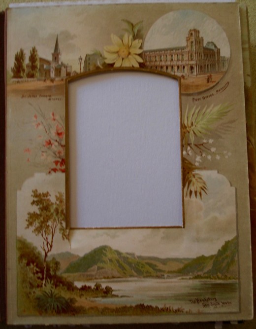
St. James Church, Sydney is at the top left of the page. Designed by the famous transported convict, Francis Greenway, this Anglican church is the oldest inner Sydney one still in existence and has been described as one of the world's 80 greatest man-made treasures.
The Post Office Melbourne is on the top right. Distances in Melbourne used to be measured from the Post Office. Both of these pictures show people walking, but there is no sign of transport of any kind and the roads appear to be unsurfaced.
The Hawkesbury New South Wales is the larger picture at the bottom of the page. There is a house with a stone chimney in the distance and even further away, near some cleared land where animals graze, there is another building and a couple of boats pulled up on the shore.
New South Wales and Ballarat
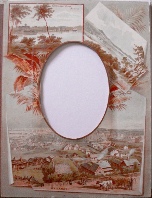
Government House, Sydney, the home of the Governor of NSW is at the top left. The picture shows some buildings and a three-masted sailing ship.
Port Stephens: The picture on the top right is of Port Stephens, with some buildings in the distance, a building a little closer with some horses in front near the water, and a black swan in the centre.
Ballarat, Victoria is in the lower picture. It is quite a good sized city; many of the houses are made of wood, as are the fences. In the foreground a fashionable couple, the gentleman with a black top hat and a walking-stick, watch a pair of bullocks hauling a load of new-mown hay up the hill and being urged on by the farmer. The Eureka Rebellion of 1854 took place near here.
Victoria Valley, Sydney and Broullee
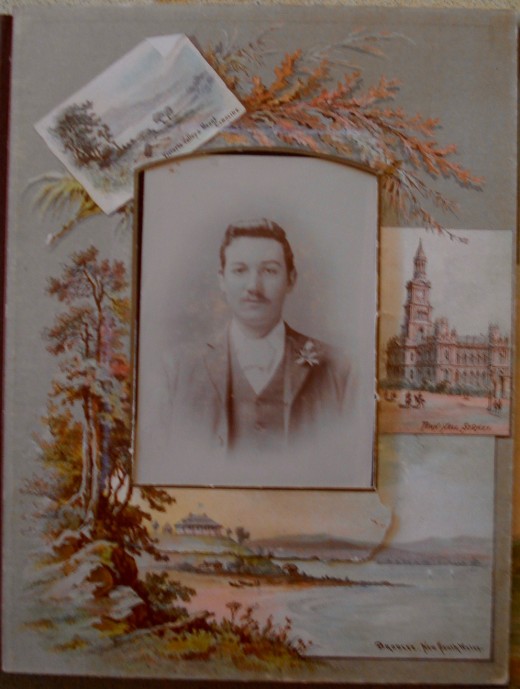
This one has a photograph - a white cravat and a button-hole, so it's most likely a wedding photo.
Victoria Valley: The top left painting is entitled 'Victoria Valley and Mount Caroline.' Victoria Valley is in Central Victoria, near the Glenelg Highway, but I've never heard of Mount Caroline and 'Whereis' hasn't either. Sometimes original place-names disappear or are replaced.
Sydney Town Hall: On the right is the Town Hall, Sydney, which includes two men on horseback sharing the road with pedestrians.
Broulee, New South Wales is the subject of the lower picture. On the coast between Batemans Bay and Moruya it is interesting because Broulee Island over the years is sometimes an island and sometimes not; at times there has been a deep, navigable channel with a strong current between it and the mainland. It was the site of the first harbour in the area south of Batemans Bay. In the early days mail was delivered weekly from Braidwood, over the mountains. Gold was discovered nearby. The Broulee Harbour disappeared for about a hundred years when the Island reformed, but recently a spit has returned.
Daylesford, Victoria and Gladstone, Queensland
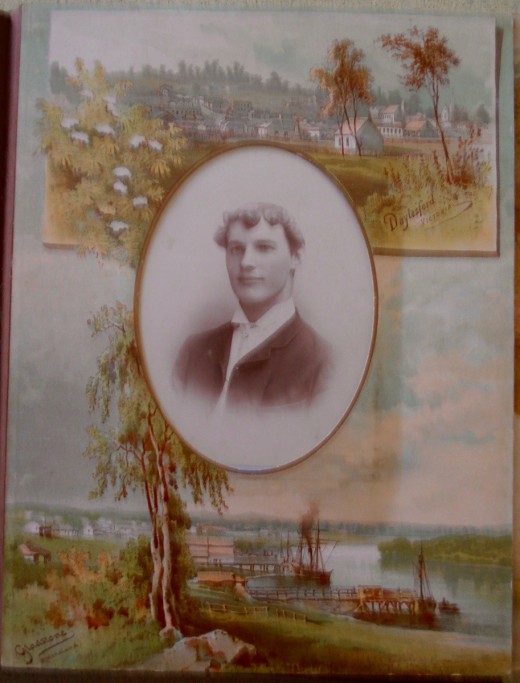
Daylesford: The picture at the top is Daylesford where my Cornish grandmother's sister went when she married, and it is where some of my cousins - and their offspring - were born. I can pick out the Anglican and Methodist Churches. We attended the latter when evacuated from Melbourne during World War II. I think I can also see the Convent where an Aunt taught piano.
Gladstone in Queensland is an industrial hub and harbour. It was a stopover when I went on a school trip after the war. We slept overnight on the 340 mile steam train journey from Brisbane, arrived at Gladstone in the morning, covered in soot from the open windows, and were very glad to find shower facilities at the station, before moving on.
Gladstone seems to have always been a busy industrial place and its port is the fourth largest exporting terminal for coal in the world, also exporting aluminium, cement products and natural gas. These products and the shipping can cause problems as the harbour is inside the Great Barrier Reef World Heritage area and the seafood industry there has been affected, too.
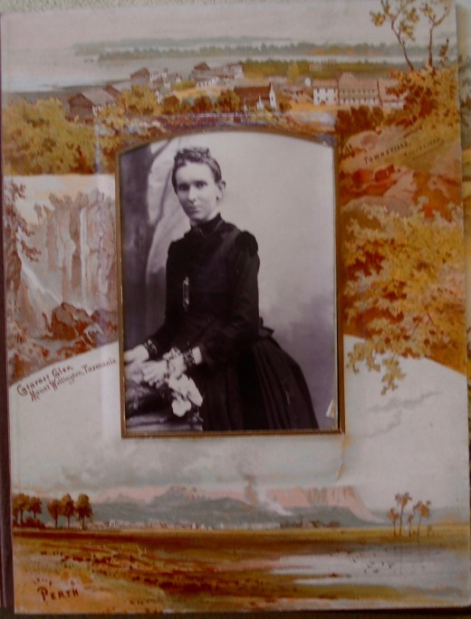
Queensland, Tasmania and Western Australia
Townsville in Queensland is at the top of the page. It's way up north and hot, although not humid, as it is in the 'dry tropics.' It's seen as the capital of North Queensland, in fact a sister of my husband there writes her State as FNQ, Far North Queensland. The Ross River runs through Townsville and is bordered by attractive parklands. The highest point, Castle Hill, is possibly where this picture was painted, looking out to the Great Barrier Reef and Magnetic Island.
Cataract Glen: In our pictorial tour we move down to Tasmania and Cataract Glen on Mount Wellington. The high, rocky mount covers a large area behind Hobart, capital of the State. It's frequently covered in snow in winter, but I've only seen and clambered on it in summer. I've counted at least ten other falls, and this one was originally named as it is in this picture, and in J. S. Prout's lithographic drawing of 1845, but today it's known as Wellington Falls.
Perth: Finally we reach the West and visit Perth, capital and largest city of Western Australia. With its high rise buildings it looks very different today. Located on a strip of land between the Indian Ocean and the Darling Scarp, the first areas settled were on the Swan River, near the port, Fremantle. Originally known as Swan River Colony, it was later named after Perth in Scotland, in honour of Sir George Murray.
In the late 19th century, after her husband died, our Great-grandmother moved there with two of her sons. A daughter had married and settled there, too, adding to our number of cousins. Perth is listed as one of the world's most liveable cities and became known as the 'City of Light' as many lights were turned on when American astronaut John Glenn passed over in the Space Shuttle in 1998.
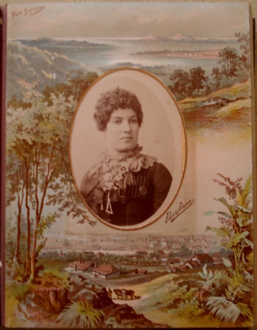
Port Lincoln and Brisbane
Port Lincoln in South Australia: The picture at the top of the page is very different from the place where my husband worked and we had a happy couple of months some years ago. It's on the shore of Boston Bay on the lower Eyre Peninsula, about 648 km from Adelaide, capital of South Australia. Needless to say, we went by plane. Known as the Seafood Capital of Australia, it is said to have the most millionaires per capita in Australia. Not far out in the sea there are fish farms where large tuna are fattened for export.
The port is busy with overseas ships loading with iron ore, wheat and other products; the local boats may be out fishing for lengthy periods. Some late afternoons we visited the town pier in and quite quickly caught enough fish for dinner and some left over for breakfast next morning. The people were friendly and there was always something happening in the town.
Brisbane is no longer the quiet city on the Brisbane River that flows 15 km to Moreton Bay and then out to the Pacific Ocean in this picture. Capital of Queensland, it has the third highest population of Australian cities and some years ago hosted the Olympic Games. It sits on a flood plane between the sea and the Great Dividing Range that runs almost the length of Eastern Australia. Named by Flinders for Scotsman Sir Thomas Brisbane, Governor of New South Wales in the early 1800s; it was founded as a penal settlement after Sydney. It can be very hot and humid in summer months, but South Bank is great for picnics on the sand and cooling off in the pools beside the river.
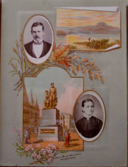
Tom Thumb Lagoon and Burke and Wills Monument
Tom Thumb Lagoon in New South Wales is pictured at the top of the page above. Bass and Flinders named it for their small boat, as they explored the coastline. One of the largest estuarine wetlands along the NSW coastline, it was just south of Wollongong and covered around 500 hectares. As we can see from the painting, there were mangroves and reed beds and much wildlife that was food for local aboriginal people. There were also dense stands of swamp oak and swamp paperbark. Then much of the site was dredged to create a deep water port for the export of steel, while the rest became a dump. Later a group formed to work on weed removal, revegetation and walkway construction. Although now greatly reduced in size, it remains a habitat for many plants and animals, including the Green and Golden Bell Frog, Coastal Saltmarsh and Swamp Oak.
The Burke and Wills Monument in Melbourne: Charles Summers designed a bronze statue with a granite pedestal that originally included a camel and aboriginal figures. It was Melbourne's first public monument, paid for by the government, and commemorates a fatal exploration expedition that set off from Melbourne in 1860 to explore inland Australia between Cooper's Creek and the Gulf of Carpentaria. The monument was placed on a pedestal of Harcourt granite at the corner of Collins and Russell Streets. It has been moved several times; one of these was to Gillott Reserve in Spring Street, and I think this is where it is in the picture. I love the huge bustle on the lady in red. After restoration, the sculpture now stands at the south-east corner of Swanston and Collins Streets.
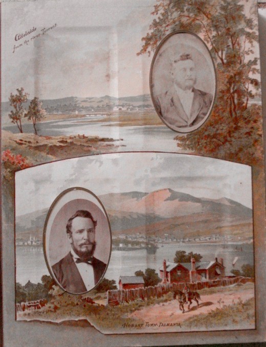
Two State Capitals: Adelaide and Hobart
Adelaide is the capital city of the State of South Australia. At the time of the painting, it was the third largest city in Australia, and is now the fifth largest, partly because over 75% of the State's population lives in greater Adelaide. Situated near the River Torrens, between St. Vincent Gulf and the Mount Lofty Ranges, it was named in honour of the queen consort to King William IV. Colonel Light designed the city as a British province for free settlers; it is surrounded by parklands and laid out with straight, wide streets. Noted for its religious freedom, it is known as the City of Churches.
Hobart, the capital of the State of Tasmania, is an island south of Victoria that began as a penal colony for convicts from Britain, and many residents proudly trace their ancestry to convicts who were transported for minor offences, such as stealing a loaf of bread for their starving family. It was named for Lord Hobart, Colonial Secretary. Situated on the Derwent, it was known as Hobart Town, as in the picture.
Soon free settlers arrived and only about thirty years after its founding it was visited by Charles Darwin who wrote about it and the Derwent estuary in his 'Voyage of the Beagle.' The Derwent River became a whaling and sealing centre and one of Australia's best deep water ports. Hobart Town grew quickly, became a city and was renamed Hobart in 1881, which perhaps helps to date the Album.
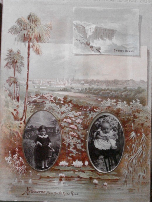
Sydney Heads and Melbourne
Sydney Heads: As can be seen in the picture at the top of the page, Sydney Heads are rocky cliffs. They face the Pacific Ocean and are often known simply as The Heads. They seem like two promontories about 2 km wide that form the entrance to Sydney Harbour, but are actually part of a series of Heads that include North Head, a sandstone promontory south-east of Manly and part of Sydney Harbour National Park. Quarantine Head is located on North Head and is one of the quarantine facilities that operated in each Australian state until the 1980s. South Head has Hornby Lighthouse, Australia's third oldest, while 3 km south is Dunbar Head, home of Macquarie Lighthouse, Australia's first lighthouse. Middle Head, Georges Head and Chowder Head lie to the west, inside the Harbour.
Melbourne is capital of the State of Victoria and its picture, which is captioned 'from the St. Kilda Road,' covers most of this page. The second most populated city in Australia after Sydney, It was founded on the banks of the Yarra River which flows into Port Phillip Bay and extends towards the Dandenong and Macedon Ranges and around the Bay. Named in honour of a British Prime, Minister, 2nd Viscount Melbourne, it became a capital in 1851. Shortly afterwards, the Victorian gold rushes began, making it one of the world's largest and wealthiest cities. After Federation in 1901, and until 1927, it was Australia's seat of government.
The Warragamba, Sydney GPO and Port Phillip Heads
The Warragamba is a NSW river that flowed through a deep gorge and then opened into the large Burragorang Valley. Following World War II, plans began to dam it as a water supply for Sydney. Completed in 1960, it formed Lake Burragorang, one of the largest reservoirs for urban water supply in the world. This picture was painted well before that and its beauty is reminiscent of John Skinner Prout's 1843 painting of the river.
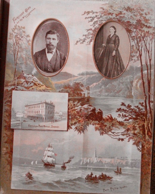
Sydney GPO, the General Post Office Sydney, is an imposing building. In the picture it is surrounded by other buildings, but the people are walking on the road and there is no sign of any transport.
Port Phillip Heads: Port Phillip Bay is fairly shallow and ships entering must follow the deeper channel, said to be the Yarra River that once emptied into the sea at the Heads before the land sank, forming the Bay. The Mornington Peninsula ends at Point Nepean, site of the old Quarantine Station; the other side is Point Lonsdale, site of the lighthouse and old fort, now tourist attractions. The space between the Heads, the Rip, is narrow and when the tide is running it can be dangerous for boats and those attempting to swim across.
The picture shows a number of small fishing boats, sailing boats and a large sailing ship that has just passed through the Heads, possibly having been assisted by a Pilot from Queenscliff who would have boarded the ship up a rope ladder out in rough Bass Strait to steer the newcomer through the Heads; he has now climbed back to the Pilot boat to return to shore. This still happens, but with more modern Pilot Boats.
Victoria's Parliament House, Sandridge, Victoria, and Newcastle, NSW
This is the last illustrated page in the Oglethorpe Album; the remaining pages are photographs.
House of Parliament, Victoria: Until 1927 Melbourne was the seat of government for the Commonwealth of Australia, so this was - and still is - an impressive building, but today I would not be strolling along the road with all the trams and traffic there. The painting includes a vehicle drawn by a single horse.
Sandridge, Victoria: This is a place name that can be confusing, even to locals, as it no longer exists, except as the name of a railway bridge that is now a pedestrian and cycle path featuring public art. The original bridge was part of the first passenger railway line in Australia; it ran between what is now Flinders Street Station and Sandridge, on Port Phillip Bay. Sandridge is now known as Port Melbourne.
Near Newcastle on the Hunter, New South Wales: Newcastle is the second most populated area in NSW. It is 162 km north of Sydney at the mouth of the Hunter River, which was named for the NSW Governor, John Hunter. It was first explored by Lt. Shortland who was searching for convicts who had seized a ship sailing from Sydney Cove. He discovered coal there and it became the colony's first export. The miners were convicts, sent there as harsh punishment, and it became a dangerous place. In this picture, the mouth of the Hunter appears quite rural and there is no sign of Christ Church Cathedral, which dominates the today's skyline.
A Wishlist Poll
Which Australian state would you prefer to visit for a holiday?
© 2016 Bronwen Scott-Branagan


