Hurricane Season, Knowledge Is Power

.")

By Joan Whetzel
Every summer a new Atlantic hurricane season begins, and with it comes the worries about which states and which communities will be affected, how many storms will crop up and what category each storm will fall into. With all the updates in equipment and forecasting techniques, weather forecasters have an easier time following hurricanes and providing a rough estimate of landfall with enough accuracy to get people out of harm's way in advance of the actual landfall. A well informed public is armed to protect themselves, their property and others - provided they heed the warning and take action.
When is Hurricane Season?
Hurricane season begins every year on June 1st and ends November 30th, with the period from August through mid-September being the most active. These monster storms have generally have a 7 to 10 day lifespan, and can traverse the open waters at speeds of around 250 miles per day; which means they don't stay over one are more than about a day to a day and a half. Eleven tropical storm systems develop each year over the Atlantic, Caribbean, and in the Gulf of Mexico, many of which never make landfall. On average, only about 6 of these 11 storms actually develop into hurricanes.
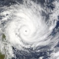
What are Hurricanes?
Hurricanes are described as cyclonic tropical storm systems with sustained of 75 miles per hour (mph) or greater. The storm spins in a counter-clockwise direction around a central eye, which usually has no rain and calm winds at its core. These storms are accompanied by the obvious high winds as well as rain, thunder, lightning, and storm surges and have been known to spawn tornadoes in their wake. The early stages of hurricane development are known as tropical depressions and tropical storms. The descriptions of each stage of the hurricane's development are as follows:
· Tropical Depressions have winds in the 25 to 28 mph range along with rain.
· Tropical Storms produce winds in the range of 39 to 74 mph.
· Category 1 hurricanes have winds from 75 to 98 mph and produces minor damage to buildings, trees and power lines.
· Category 2 winds occur between 96 and 110 mph, producing damage to roofs and chimneys, crops and shrubbery, road signs and traffic lights, windows and tossing about small boats.
· Category 3 hurricanes have winds at 111 to 130 mph, which cause severe damage to plants and property, as well as annihilating mobile homes, uprooting large trees, tossing around small planes and flattening homes along the coastline.
· Category 4 winds range from 131 to 155 mph. These storms rip roofs off homes and buildings or dump so much rain in a short period of time that the roofs collapse. Coastal waters crash violently enough to splinter piers, shatter seawalls and carry small boats quite a ways inland.
· Category 5 storms carry winds in excess of 155 mph and can level entire cities and landscapes.

Saffir-Simpson Scale
Hurricanes, which are categorized according to their wind strength are listed on the Saffir-Simpson scale. This scale not only illustrates the wind strength of each category, it also records an inventory of the damage caused by each category, the storm surge produced by each category ( in feet), and the barometric pressure at the eye of each storm. The lower the pressure goes (either in millibars or inches of mercury (Hg)), the smaller the eye becomes which in turn produces rotation of winds around the eye and greater wind strength. In other words, a more powerful storm.
Of course, assigning a category to storm comes with a caveat. Sometimes hurricanes in the lower categories can cause more damage than a higher category storm. Take for instance Hurricane Ike in 2008, which only a Category 1 storm when it the Texas coastline near Houston Galveston at high tide, bringing with it a strong storm surge well in advance of the storm. As another example, Tropical Storm Alison which hit the upper coast near Galveston Houston, and stalled out for about 15 days, partially over land and partially over water, dumping over 40 inches of rain along the coast and Houston area, causing severe flooding the likes of which Houston and Galveston have never before seen.
Hurricanes Watches and Warnings
Hurricane watches and warnings are issued well in advance of the storm making landfall. They are issued based on projections of possible or potential landfall based on the latest computer models. Hurricane watches warn of possible hurricane landfall along about 400 miles of the coastline to occur within the next 36 to 72 hours. Hurricane warnings narrow the landfall predictions to a region of 25 to 50 miles of coastline, with watches extending outward in each direction for 300 miles, and predictions of landfall occurring between 24 and 36 hours.
Hurricane Formation
Hurricanes are fed by warm water. In addition, rapidly rotating lower level winds guzzle warm, most ocean air. The spinning motion creates a vortex - something like a whirlpool - that siphons the warm, moist air and the warm water like they're being sucked up through a straw. The upper levels of the developing storm contain slower winds and cooler, dryer air. When the warm air and moisture that was sucked up through the vortex meets the cooler drier air, it condenses and produces rain, which falls back the ocean where the cycle begins again. The continuing cycle is what stokes the storm, causing the hurricane to build up an energy and strength. There are only two ways to kill a hurricane, (1) the hurricane must turn north and encounter cold waters (which sucks the energy right out of it), or (2) it must make landfall (which basically empties the gas tank of its favorite fuel - warm water).
Conditions for Hurricanes to Occur
For a hurricane to develop, first there must be a weather disturbance. Add warm tropical ocean waters, moisture (humid air), and light upper level winds. If these conditions stick around long enough, they can merge to generate the brutal winds, huge waves, heavy rains and flooding associated with hurricanes.
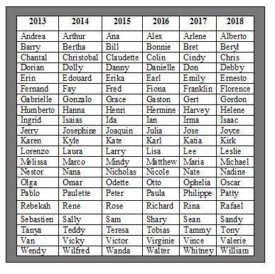
Hurricane Names
Storms are named once they reach Tropical Storm status, with sustained winds of 39mph. The 6 year cycle for the Hurricane Name list stared in 1979. The names will continue to be recycled, unless a named storm produces a great deal of damage or cause a large number of deaths. In which case the name is retired. Recently retired names include Ike and Alison (mentioned above) and of course, Katrina. Check out the list for hurricane names for the 2011 to 2016 rotation.
Tracking Hurricanes
Hurricanes and hurricane conditions are tracked with several measures. The shipping industry is helpful in that they are in a prime position to collect data on water temperatures, winds, and rain events and any other weather conditions that could lead a hurricane. The problem is, that once conditions become ripe, the ships leave the affected shipping lanes for safer waters, which decreases the available data for NASA, NOAA, the National Weather Service (NWS) and any other weather reporting agencies. The information has to be gathered in other ways.
Ocean temperatures can be gathered by passing ships, from buoys, microwave images and advanced radar from satellites. and from drop sondes attached to a wire, released from airplanes. Storms and hurricane development can be tracked with satellite radar and imagery. Buoys are now rigged with mini weather stations to collect all kinds of weather data besides just the water temperature (i.e. air pressure, wind speeds, air temperature). Hurricane reconnaissance airplanes fly into the storms at regularly scheduled intervals to determine the conditions and verify any changes in the conditions and trajectory of the storm.
Hurricane Hazards
Hurricanes produce a number of hazards as they move onshore. First on the list are storm surges, which are described as an abnormal rise in coastal waters as the hurricanes push the water ashore. As with Katrina and Ike, storm surges produce a huge amount of flooding in advance of the storm which is added to the amount of rainfall brought with the storm. The second hazard includes marine disasters, including damage and deaths from boats caught out at sea when the storm strikes, as well as the damage to ships, boats and property along shore lines. The third hazard is the destruction caused by high winds. The fourth hazard comes in the form of tornadoes spawned in the hurricanes wake. Fifth, inland flooding is caused by heavy rainfall as the hurricane moves inland.

Preparedness
Hurricane preparedness begins with obtaining a hurricane chart. In Houston, all three networks provide these free in conjunction with a partner in business (usually grocery stores). The three stations can be found at these websites:
- KTRK Hurricane Central (ABC affiliate)
http://abclocal.go.com/ktrk/feature?section=weather/hurricane&id=6139670
- KPRC Hurricane Tracker (NBC affiliate)
http://houston.justweather.com/hurricane/
- KHOU Hurricane Central (CBS affiliate)
http://www.khou.com/weather/hurricane-central/
- NOAA Hurricane Preparedness
http://www.nhc.noaa.gov/prepare/
Everyone should prepare ahead of time by stocking up or planning ahead of time in the areas.
- General supplies: overnight bag of clothes and toiletries, cash, battery operated radio, battery operated flashlight, extra batteries, 2 week supply of prescription meds, extra keys, pets and pet supplies, disinfectant, first aid kit, stock of nonperishable foods, plastic ware and paper plates, hand operated can opener, gallon containers of water, gas cans with extra supply of gasoline, know the evacuation route, and a keep a checklist.
- Repair and maintenance: plywood to cover windows; sandbags to place around windows and doors; moving outdoor plants, furniture, and other potential projectiles inside; turn off utilities if leaving home; anchor mobile homes, lock windows and doors if leaving home, prune trees and shrubbery; install storm shutters for homes close to shorelines; stock up on duct tape, tarp and ropes.
- For power outages: generator, connect to the outside world with a mobile phone or i-phone, flashlights, battery operated radio, batteries, grill, grilling supplies, nonperishable foods, gallon containers of water, plastic ware and paper plates, manual can opener, aluminum foil. ice chest with ice, fill washing machine and clean bathtub with water for cleaning and bathing.
- Special needs: limit stress and TV time for kids; have DVDs,. books, board games and CDs for entertainment; pre-register for shelters that can handle special needs; call the doctor for pregnant women or sick children and adults to advise them of your plans for evacuating or staying in place; contact any home health care service that you may be using to have them check on you after the storm is over; know the risks of staying and evacuating.
- Evacuation: find out if you're in a mandatory evacuation zone; know your evacuation routes ahead of time; plan for pets, purchase an up to date paper map or road atlas; plan where you will relocate to; plan your meeting place; sleeping bags; keep gas tank at least half full; gas cans with back up gasoline; leave when authorities advise you to do so.
- Paperwork: emergency contact information; insurance information; marriage licenses, birth certificates, social security records, immunization records and other important documents; USB drive with important information on your desktop computer uploaded as backup; family photos and photo albums; deeds to your house and cars; drivers license and any other proof of residence (or authorities may not let you back into the area to check on your home); passport; a list of serial numbers for computers, home entertainment system, etc.; fireproof and waterproof safe.
For those who have never been through a hurricane before, this may sound like a lot to remember - and a lot of work. But once you've been through a hurricane drill, it doesn't seem so overwhelming. The trick is to buy some of these supplies (batteries, non-perishables, flashlights, boards and nails to cover windows, gallons of water, etc.) over time well in advance of hurricane season or right at the beginning, before any hurricanes have a chance to develop. Having these things on hand as a matter of course, will save you the time, trouble and money - and stress - of having to shop for everything at the last minute as the hurricane is approaching.
Bibliography
Lyons, Dr. Steve. The Weather Channel. How Strong is that Hurricane? Downloaded 1/23/2012.
http://www.weather.com/blog/weather/8_15152.html
MIT News. MIT Researcher Uses Simple Ocean Measurements To Predict Hurricane Intensity. Downloaded 1/23/2012.http://web.mit.edu/newsoffice/1999/hurricane.html
Gutro, Rob. NASA. Recipe for a Hurricane. Downloaded 1/23/2012. http://www.nasa.gov/vision/earth/environment/HURRICANE_RECIPE.html
Goldman, Jane. NOAA. Noaa Hurricane Hunter Remote Sensing Device Gets High Marks For Measuring Hurricane Sea Surface Wind. Downloaded 1/23/2012. http://www.publicaffairs.noaa.gov/releases2003/feb03/noaa03019.html
National Weather Service, National Hurricane Center: The Saffir-Simpson Hurricane Wind Scale. Downloaded 1/12/2012.
http://www.nhc.noaa.gov/sshws.shtml
Merolla, Lisa. Cosmos. Lightning is New Hurricane Prediction Tool. Downloaded 1/23/2012. http://www.cosmosmagazine.com/news/2671/lightning-tool-predict-hurricanes
National Weather Service, National Hurricane Center. The Saffir-Simpson Hurricane Wind Scale Summary Table. Downloaded 1/23/2012.
http://www.nhc.noaa.gov/sshws_table.shtml?large
Modern Survival Blog. Hurricane Preparedness List. Downloaded 1/23/2012.
http://modernsurvivalblog.com/weather-preparedness/a-hurricane-preparedness-list/
NOAA. Hurricane Preparedness. Downloaded 1/23/2012.
http://www.nhc.noaa.gov/prepare/