Kerala Floods 2018, Is It Manmade?

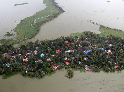
The recent flooding in Kerala is the worst in the history. About a century ago, in 1924 Kerala witness the natural furry on a larger scale and popularly known as "99 le vellapokkam" (99 represents the year 1099 in the Malayalam Era and the meaning of the phrase is Flooding of 99). It was the largest flood of the history till August 2018. The state started receiving heavy rains from August 8, 2018 onward.This Monsoon rains was cited as the cause of the "once-in-a-century" flood that displaced nearly a million people, caused hundreds of fatalities, and washed away homes. But news reports state that the flooding was worsened by 80 major and minor dams were overrun by torrential rains. The local government is failing to gradually open the dams, waiting instead until they were already full before unleashing the excess water. #keralaflood #kerala #keralafloods #standwithkerala #flood #doforkerala #keralafloodrelief #prayforkerala #rebuildKerala
Floods
Normally, the flooding of rivers is a very gradual process as it takes time for enough rainfall to infiltrate through the ground and cause the water level to rise sufficiently so that it overflows before reaching the sea.
Flash flooding, however, gives no such warning.
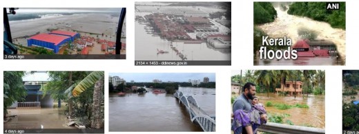
The region receives Record rainfall in the first three weeks of August. All the 44 rivers in state were flowing over the flood level. At last authorities were forced to release water from 35 dangerously full major dams, sending it surging into overflowing rivers
“This could have been avoided if the dam operators had started releasing water in advance rather than waiting for dams to be filled up, when they have no alternative but to release water,” water expert Himanshu Thakkar told.
India’s Central Water Commission has also been under fire for failing to introduce a flood forecasting system to issue warnings.The coastal state truncated with numerous rivers and streams doesn't have a flood map or a management plan to counter natural calamities like the recent floods. Both the Central Water Commission (CWC) and the Kerala government are groping in the dark on the ways to manage challenges posed by downpours and floods. The recent experience proved that neither the CWC nor the state water resources department had a plan to manage the after effects of the deluge. The revenue department, KSEB and the disaster management authority had no clear idea where the flooding could take place.
The scale of the disaster would have been reduced if proper steps had been taken to conserve the region.
— Scientist Madhav Gadgil, who had submitted a report on the Western GhatsBefore and After the Kerala Floods
 on the Landsat 8 satellite acquired the left image (bands 6-5-3) on February 6, 2018, before the flood")
 on August 22, 2018, after flood water had inundated the area.")
Flood on Press

Rain Fall data
In just the first 20 days of August, Kerala has received the highest rainfall for the entire month in 87 years, India Meteorological Department (IMD) data reveals.
The state has got 771mm rainfall from August 1 to 20 this year. This the highest for the month since 1931, when Kerala had witnessed its wettest month of August on record with 1,132mm of rain, said Pulak Guhathakurta, head of the climate data management and services, IMD.
Opening of Dams
For the first time in Kerala during the south-west monsoon, all the 40-odd rivers were in spate. Reservoirs were filled to the brim and shutters of 80 dams were opened to release water.
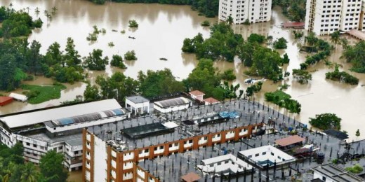
The Aliyar dam in Upper Sholayar was opened by Neighbouring state Tamil Nadu, without warning, thus flooding many parts of Thrissur and Chalakudy, while there are charges that no red alert was sounded before the dams of the Sabarigiri scheme were opened, resulting in severe flooding. Local MLA Raju Abraham said even before any warning, Ranni in Pathanamthitta had started flooding, adding there were lapses in the opening of shutters of Kakki and Pamba dams. Allegations have also surfaced that three shutters of Banasura Sagar dam in Wayanad were opened without even informing the district collector.
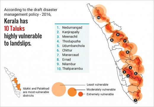
Landslides
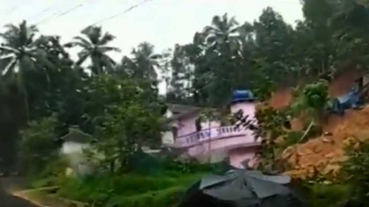
During this years monsoon season, more than 1000 landslides of varying magnitude has been reported in the state. These landslides causes many casualties in the state. As per our study on the western ghats, the steep sloped areas of the western ghats are prone to landslides and have recommended relocation of houses on many areas. But after 22 years of submission of that report, construction of houses in those areas were doubled. The recent flooding and landslide have washed away most of those houses. The increased number of Quarries in the environmentally fragile area is also a contributing factor.
See the following maps of landslide prone areas and Environmentally fragile areas.

Wetland Reclamation
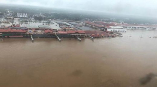
The international airport in Kochi, a major port city, has suspended all flights for more than 14 days. The runway and Airport building were submerged for days and no operations were possible for days.
The Airport is built by reclaiming 1500 Acres paddy field and blocked a wide canal. Now the flood waters entered to the airport from the blocked canal, which find its its original natural course. Kerala has witnessed a large scale wetland conversion during the last few decades. These wetlands were act as the buffer zone for the flood waters in the past. These are also instrumental for ground water recharge.
Ironically, the state of Kerala, which is blessed with six months of monsoon and having 44 rivers, is facing acute drinking water scarcity in the summer in the last few years.
After reading this what you think? Is it man made?
Kerala Floods 2018, Is It Manmade?
Conclusion
From all these, it is came to conclude that the disaster is a natural calamity, but it is intensified by human acts like Poor Dam Management, and bad land use practice and widespread wetland conversion.
Either way, the state will have to implement long-term measures to limit catastrophes of such magnitude.
© 2018 MANOJ BALAKRISHNAN
Related

The Landlord and the Flooded Rental

West Virginia Flooding 2016: "West Virginia Strong" and the Aftermath

Even the Best Flood Protection Systems Cannot Protect Against Stupid Developers and Planning Decisions

What Kerala Can Teach India & China About Population Policy

Kerala In South India The Land of Heaviest Boozers


