Mars Colonization May Need to Consider Marsquakes and Volcanoes

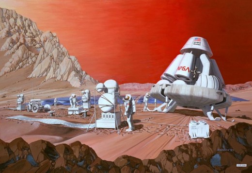
Will Mars Have Terrarium Cities?
With the advent of asteroid mining and planned lunar mining by Planetary Resources, of whom James Cameron and Google VIPs are part, Living on Mars may be very near in the future. It depends on the experiences of astronauts living on the International Space Station for a total year sometime around 2014. If they remain healthy, then further long term habitation in outer space is a possibility.
The closing scenes of TV's Life on Mars finale depicted a barren dusty-looking red planet with mountainous formations at the ends of long desert reaches. At night, it was colder than the Kalahari and more bleak.
Can people live on the face of Mars under climate-control domes in future cities? Can we establish a climate with atmosphere-attracting plants, trees, and water beneath the domes like giant terrariums and open them all at once after we cover the planet with them?
Before all that, does Mars experience tectonic activity that results in volcanic eruptions and Marsquakes in the 21st Century?
These events would affect human colonization attempts beginning in between 2013 - 2020, as early as 2015 - 2018, if certain countries' plans gel. Even Holland wants to go to Mars.

Tectonics or Not?
As late as the 1998, a portion of involved researchers felt that their studies showed no evidence of tectonic activity or even tectonic plates under the surface of Mars. However, NASA found evidence of tectonic history in 1999 (see reference 2. below).
Prior to 1999, Viking 2 on Mars radioed back to Earth the recording of a single possibly seismic event via its seismometer before end of transmissions on April 11, 1980 (NASA, 1980). This had paved the way for researching the history of land quakes and possible current or even ongoing seismic activity on Mars.
Evidences of Quakes
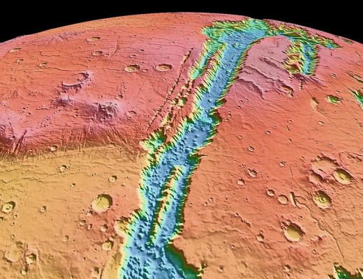
Valles Marineris, or Valley of Mariner, is a long, wide canyon system that runs along the Martian equator just east of the Tharsis region, covering over half of the mid-line of the planet. It is likely a very large tectonic break in the Martian crust.
Valles Marineris : As Long as 6 Grand Canyons as as Deep as 8

Early 21st Century Research
Studies in 2005 - 2008 offered a second and third opinions such as these --
- Golombek, M.; Phillips, R. Mars Tectonics. American Geophysical Union, Fall Meeting 2008. December 2008. [Golombek and Philips have been affiliated with Jet Propulsion Laboratory, Caltech, Pasadena, CA and Southwest Research Institute in Boulder Colorado.] -- Martian tectonics centers on the Tharsis string of volcanoes and related tectonic ridge. Certain formations indicate a moat formed around volcanic activity, which may have released water and magma in a layer reaching to 100 m thick above the surface of Mars.
- NASA. Plate Tectonics on Mars. "Magnetic Stripe" Evidence of Plate Tectonics On Mars. NASA News; October 12, 2005. - .A map of the magnetic field around Mars was constructed by the Mars Global Surveyor spacecraft’s magnetometer and examined by NASA personnel. They had first discovered evidence of Martian plate tectonics in the Southern Hemisphere in 1999. However, the newer map is based on 4 years of accumulated mapping data over the entire face of the planet. Magnetic striping is evidenced several places around the planet, as are a kind of seismic faults (Transform type that indicate tectonic shifts). Scientists found magnetic stripes pointing in different magnetic directions, which indicates tectonic movement. Earth has this same type of alternating striping. Tectonics are thus indicated by: a) a magnetic pattern, b) the Tharsis volcanoes arrangement in a straight line – a fault line, and c) the Valles Marineris canyon as long as six Grand Canyons and much deeper, looks physically and magnetically (by orientation) like tectonic activity opened it.
It is believed that tectonic activity may be only in the past of Mars, not to occur in future, However, this status might change as scentific examination progresses. With evidence in the 2000s suggesting the possible existence of methane gas, bacteria, and water on Mars, there are always possibilities.
Volcanoes Add to Tectonics
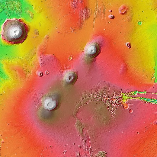
NASA discovered during the 1971 and 1972 portion of the Mariner 9 mission that volcanic features cover large surface areas of the Martian landscape. The Tharsis Region is full of dead volcanoes.
Martian Volcanoes Made Some Marsquakes
On Earth, an earthquake releases enough energy to produce seismic activity in the form of faults moving and tectonic plates shifting. The volcanoes of Mars are much larger than those of Earth, while the iron-colored planet is smaller than our blue and green one (only 54% the size of Earth).
It is probable that much more energy was released by the Martian volcanoes during a time in which the planet was cooling and water was running, and this energy spewed up much of the molten core of the planet as water cooled it to form gigantic surface structures. The remaining moisten structure at the planet's center also cooked to form a solid ball.
With the absence of molten content in the center of Mars, Marsquakes likely occur much less often today, although a meteor strike may cause tectonic shifts in the fault lines such as those in the Tharsis Region and its nearby canyon.
Valles Marineris, as shown in images above, is a horizontally sliding tectonic boundary or fault line. Infrequent quakes may occur only in this tectonic boundary and only in the planet's crust.
Line of Volcanoes Through the Tharsis Region
Martian Tectonics Research 2000s - 2010s
Robert Roy Britt. Marsquakes: Red Planet May Still Rumble, in Space.com; October 11, 2004.
David Farrell of the Southwest Research Institute mention above at University of Texas found from Mars images that the planet's surface has chains of pits in rows that might be sinkholes that occur when tunnels are created by running water or lava tubes when hot magma carves tunnels.
The pit chains in Iceland were formed on a fault line beginning only in 1975. Erosion, in a way, widened these pit structures and chains resulted. Comparing examination of Martian and Terran data, it looks as through the pits on Mars were formed in the same manner as those of Iceland.
Mars' lower gravity results in steeper fault features that reach farther down into the planet's crust than is found on earth. This makes larger pitted areas. One item is interesting: the lack of sediment at the bottom of the pits might mean that the pits are fairly new, so tectonic activity might be occurring in the 21st Century.
The High Resolution Imaging Science Experiment (HiRISE) is the latest imaging project above the Martian surface. HiRISE has captured images of avalanches at the north polar ice cap as they have happened and imagery evidence suggests that these avalanches may have been caused by seismic activity. However, it is widely thought that the Martian core is solid and therefore, does not provide the potential for seismic activity.
Other researchers think that seismic activity may occur in the crust of Mars alone (Knapmeyer, M., Oberst, J., Spohn, T. Of Moonquakes and Marsquakes. Final Colloquium DFG Schwerpunkt 1115, Münster (Germany), 02/28 - 02/29/2008). However, the scientists in this last reference predict 20-30 Marsquakes per year based on their statistical models.
Research in the 2010s
A study in the 2010s suggests that Marsquakes may happen only every one million years, these findings based on researched evidence of Mars's tectonic boundaries. Reference: "Mars Surface Made of Shifting Plates Like Earth, Study Suggests"; Space.com Staff, 8/14/2012.
Valles Marineris: 2,500+ Miles Long
Research From 2016 Through the 2020s.
Are Marsquakes a Danger to Colonization?
By 2016, researchers and members of the Mars Society felt that Mars may or may not experience quakes. If there are quakes, they may number 20 - 30 per year.
Opinions are summarized roughly as follows: If Mars provides seismic activity, it is probably seismic activity at lower levels than on Earth and less widespread across the planet.
The highest risk of seismic activity and with it, quakes and volcanic activity, may be at the Martian North Pole, so it would be wise that settlers do not build colonies in this region, except perhaps for a research station or two, similar to those Earth possesses in Antarctica.
It would be wise planning to continue to collect imagery and seismic data from Mars and use it to create a seismic map before venturing forward to colonize the planet.
Next Steps
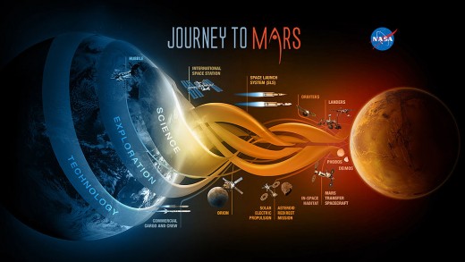
According to NASA during 2018, InSight (Interior Exploration using Seismic Investigations, Geodesy and Heat Transport) was a mission that placed a single geophysical lander on Mars to study its deep interior. From 2018 through 2024, the ARTEMIS I-II-III project began to facilitate landing humans on Mars as well by the middle to late 2020s.

This content is accurate and true to the best of the author’s knowledge and is not meant to substitute for formal and individualized advice from a qualified professional.
© 2009 Patty Inglish MS MPH
")