Ocean Navigation in the Days of Columbus...

Ocean Navigation Inventions...
Navigation on the oceans and seas of the fifteenth century was a difficult time at best, and wrong estimations of ships position often caused shipwrecks by being cast upon shoals or shore in the middle of the night because the captain thought they were safely out to sea and not close to the coastline. It was a bad time to be a sailor, as safety depended on the captain’s knowledge of the waters they were heading to, and often his past experience with currents, wind, and figuring position though use of some of the mariner’s tools available at that time. In the early days, there wasn’t much at all with regard to tools except for the compass, and that was very primitive at best. Though the years, various other instruments used to take positioning data with regard to the sun, moon, and stars were created which include the astrolabe, cross-staff, back-staff, quadrant, sextant, and octant. All were very useful during their time, and in addition there were many great advances in map science and cartography.
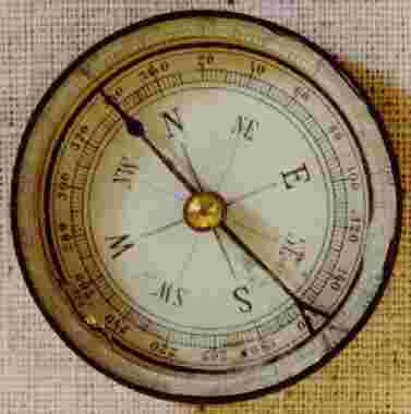
The early compass was only starting to be used on ships during the 11th or 12th centuries, but wasn’t until the mid 14th century that it became commonplace on ocean going vessels. In fact, around this time or shortly thereafter was when the gimbal was used in unison with the compass, so that the direction was easier to find with all of the rocking and rolling of the ship as it was tossed with the waves. The compass was traditionally kept near the helmsman position on the quarterdeck in a large box called a binnacle. This was where the important navigational equipment was kept so that the helmsman could steer correctly, and included a lantern and hourglass in addition to the compass. The lantern was to read the compass at night, and the hourglass was mainly used for the change of watch every 4 hours or so. The hourglass was a half hour glass, so it had to be turned over every half hour to keep the time straight. It was also used to call out the time for calculating the ships speed using the log and line. Every so often the magnetic compass needed to be remagnetized using a lodestone, in order to keep it working correctly. Since magnetic meridians do not always coincide with geographical meridians, the mariners would have to calculate for the difference between true north and magnetic north using a variation or magnetic declination. One method to figure the declination was to take readings of the rising and setting suns, then figuring out a horizon angle… It was time consuming but still needed to be done for correct readings.
Compass and Quadrant...
The compass eventually evolved into an azimuth compass, which included a quadrant attached to the compass and using the shadow that was cast to read the correct direction. Later on toward 1730 or so, these azimuth compasses were equipped with sights to better ascertain ships position, especially when in sight of land. They could use landmarks on shore to give an accurate reading after figuring for the variation.
Another useful instrument was the quadrant, which was invented by the American Thomas Godfrey and the Englishman John Hadley around the same time, 1731. The quadrant was a simple wooden or brass quarter of a circle with two sighting vanes along one edge. A plumb line was suspended from the center which indicated an angle between zero and 90 degrees of arc. However, the sea astrolabe and cross-staff followed this early quadrant and were more popular. After the quadrant was created, it was slowly morphed into an octant and a sextant, which just created larger angles for viewing. According to “The Illustrated Longitude”, the octant soon helped sailors find both their latitude AND longitude. The sextant incorporated a telescope and a wider measuring arc, which allowed for the precise measurements of distances between the moon and the sun during daylight hours, or between the moon and stars after dark, for use with the lunar distance method.
The sea astrolabe consisted of a heavy brass ring with degrees between zero and 90 and its complement engraved on the upper half, and was suspended on a ring. Two sights revolved around a central pin and when an imaginary line through the center of the sights was directed at a celestial body, then its altitude and zenith distance could be read. However, it was a very bulky and clumsy instrument to operate, could not fine tune small degrees, and was also expensive to operate due to the cost of the brass. It was eventually phased out around 1700 or so with help from the popularity of the back-staff and cross-staff.
These instruments also helped in measuring the altitude of celestial bodies. The cross-staff had 4 crosses, 2 for each side, that a mariner could slide up and down until he sighted the horizon in one, and the celestial object being measured in the other. Then it was easy to get the readings right off the staff. The back-staff was an improvement over this because one could measure the object with his back to it. This helped save the eyesight of many a seaman, since the sun could be brutal with constant measuring. The back-staff used a series of mirrors which also helped on overcast days.

Log and Line, Longitude, and Dead Reckoning...
The “log and line” mentioned earlier helped captains find the speed of the ship and is also where we get the term “knots” today. A knotted rope with a log at the end was tossed in the water and timed to see how many knots get rolled out during a certain time period. Then you could total up the number of knots, and say you were going “7 knots” or so… There was also a “lead and line”, which was used to see how deep the water was and also had a little scoop at the bottom in order to bring up a sample of the bottom soil to further solidify the ships position.
One of the major problems was for a mariner to find his longitude position at sea, because it was unknown how to do so for a very long time. A captain could only estimate his position based on experience until the 1700’s. John Harrison created the very first highly accurate sea clock that kept the time of the home port and could help the mariner calculate the current ship time with the help of other astronomical observations and knowledge of ship speed. Until Harrison’s clock, the best a clock could do was lose about 15 minutes a day or so, but his sea clock kept time to better than 3 seconds a day! This vastly helped captains explore the world better and to keep good records of any new landfall they encountered, such as in Captain Cooks voyages. There were an incredible amount of astronomical observations kept with regard to lunar distance positioning and also the 4 moons of Jupiter, and much of this was also placed into journals or books for the mariner to take with him on the ship.
Dead reckoning was also quite frequently used to navigate, and is also a practiced skill for mariners today. It takes into consideration mean speed and course, and also the effect of the wind and tide. A compass, dividers, a chart, tables, log and line, Dutchman’s log, and traverse board were used. Celestial navigation was not used for this, except as a correction if it was available. Quite often large errors happened as a result of using this method.
Dutchman's Log and Marine Cartography...
The Dutchman’s log was popular with the Dutch where a log would be tossed overboard and the time it took for it to pass the length of the ship would be calculated and a proper speed established. A Traverse board was basically a board with several small holes in it, some indicating speed and some indicating compass points. Every half hour a hole would be plugged with the steered course and another one with the logged speed. Then every 4 hours the speed and course could be read from the board.
Marine cartography also became much more advanced, with the proliferation of many very good charts that were highly detailed from previously. The Flemish cartographer, Gerard Mercator, developed a cartographic projection that took into place the deformation that most other maps showed due to the curvature of the Earth. They showed the Earth as if it was flat, but Mercator showed it the way it actually is, as if you could roll up the paper into a globe.
With these and other maritime navigation advances through the years, shipping has become much safer with fewer losses. Today, all ships use satellite charting and GPS positioning to keep track of where they are in the ocean, and it can be very easy to get out of practice of using any other techniques! If out on the open ocean using electronic positioning methods and you somehow lose all your electrical power, it is always good to know some kind of manual backup method… Most ships or boat owners probably don’t have a sextant lying around though, or if they did, know how to use it!


