Predicting Future Sea-Level Change
Introduction
As the planet Earth continues to change in unprecedented ways, the ability to accurately predict future sea-level change is crucial. A rising or falling sea level can determine where species can live and where they cannot; consequently, vast numbers of populations will have to adapt to what is predicted to be a global sea-level rise. In addition, sea-level rise is being increasingly blamed on anthropogenic activities, such as the burning of fossil fuels that enhance the greenhouse effect. It has been estimated that: “The total anthropogenic sea level rise…is 11.8 mm, with an average rate of rise since 1960 of 0.54 mm yr-1” (Sahagian, 56). Global sea-level change is measured by either tidal gauges or satellites. Their data is then used to help project future sea-level rise with the use of equations that produce models. The information gained by this process can make the difference in determining how coastal areas can adapt or change to future sea-level rise.
Summary
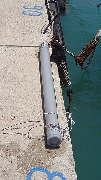
The use of tidal gauges to measure sea-level has been used since about the latter half of the 19th century (Mitchum, 1994). Tidal gauges are relatively easy to use. The most commonly used tidal gauges, pictured to the right, have a float within an area that captures water, called a stilling well. The stilling well mechanically filters sea level variability caused by high-frequency surface gravity waves. Sea-level is measured as the distance from the recording instrument to the float (Mitchum (1994)). Tidal gauges have been placed all over the world’s oceans (as seen in Figure 3). In most cases, the information gathered from tidal gauges is transmitted to land stations for further analysis.
Hubs on "The Control of Nature"
- Cooling the Lava: The Battle to Save Heimaey
Read about the terrifying ordeal of waking up to an active volcano erupting just outside your front door and how a town was sacrificed. - Controlling Nature?
A look at John McPhee's several examples of failed attempts to control nature in "The Control of Nature." They are given to illustrate that people are the mercy of the elements.
Although tidal gauges allow a direct, thereby a more accurate, measurement of sea-level, there are a couple of potential errors associated with the data they collect. First, “It is generally assumed that islands, at least small ones, should be more representative of open ocean conditions due to the lack of continental shelves and the associated boundary phenomena” (Mitchum (1994), 24542). This means that more actuate sea-level measurements can be obtained from small islands because they are more closely located to the open ocean water. Also, the vertical motion of tidal gauges may be due to continental drift or uplift, especially in volcanically active areas (Chambers, 12885). Uplift or continental drift can cause tidal gauges to give faults high numbers for sea-level rise. Although these margins of error are small, sea-level rise is often measured in millimeters; therefore, small margins of error can make a big difference.
Hub on Writing Scientific Papers
- How to Write a Scientific Paper
Outlines good practices while writing college essays for sciences courses or scientific papers for publication.
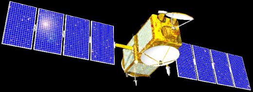
In the last 20 years, technological advances in the use of satellites to measure sea-level have greatly increased. As a result, NASA designed and launched specially designed satellites for the specific purpose of measuring global sea-level. The first was the TOPEX/Poseidon, in later years, Jason-1 and Jason-2, pictured to the right, were added. The TOPEX/Poseidon mission began in 1993. “The TOPEX altimeter provides measurements of sea surface height by differencing the satellite’s range to the sea surface and the computed height of the satellite’s orbit above a reference ellipsoid…Thus at any point in the ocean that is overflown by the altimeter, a height time series with an arbitrary vertical reference point is obtained” (Mitchum (1994), 24541). However, the TOPEX/Poseidon mission was cancelled in 2006 due to mechanical malfunctions. It was then replaced by Jason-1 and Jason-2. Jason-1and Jason-2 have slightly more sophisticated equipment but their mission to obtain sea-level data is still intact. The use of satellites in the modern technological era has allowed a much simpler way for sea-level to be measured and, because their range is not as limited, allowed scientists to obtain sea-level measurements from previously immeasurable places.
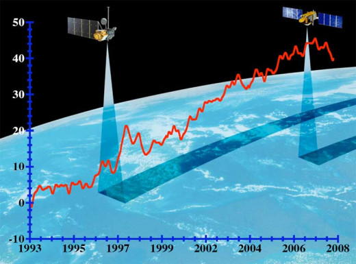
There are, however, there is one big problem with the use of satellites to measure sea-level. Satellite altimeters tend to drift with time caused by the lack of being calibrated (Chambers, 12885). In fact, one study’s conclusion on this matter states, “that an averaged time series of differences between TOPEX and tide gauge measurements indicates that TOPEX sea level measurements are drifting away from the truth” (Chambers, 12890). This poses a problem for data collection. If the satellite is not properly calibrated, it may incorrectly calculate the sea-level. This is why satellite instruments are calibrated quite frequently. Despite this minor error, satellites are still a very useful, dependable tool.
The data from tidal gauges and satellites is evaluated and taken into account when equations are made for models used to predict future sea-level change. Very complex equations like the ones below are combined to produce models for future sea-level change. These models are extremely useful for showing the nonscientific community the extent to which global warming may affect future sea-level rise.
More Climate Change Hubs
- Do You Know What Else Crude Oil Makes?
If the first thing you think of when you think crude oil is gasoline for your car, you might want to consider that crude oil is a crucial component in making these far more essential products. Simply reading the paragraph titles will give you a bette - You Are Currently Moving at about 1,000 mph!
Earth's planetary movement - Ever Wonder What is in the Air We Breathe?
The air you breathe makes a difference. - Do You Know What Peak Oil Is? If Not, You Should
For many decades, there has appeared to be an unlimited supply of oil but, like all good things, its time will come to an end.
However, the inaccuracy with models’ predictions lies in the fact that models are just models. They are a prediction of the extent to which future sea-level will change. Models are by no means the actual scenario that will play out. There are too many variables to calculate for a model to be exactly right. Models give an educated guess as to what may happen in the future but their margin of error is enough to conclude that their scenarios may not actually come to be.
Conclusion
In a world where anthropogenic forcings will have profound impacts on the Earth system it is important to try to predict how the Earth system will change. The use of tidal gauges and satellites has greatly increased the human knowledge of how to measure sea-level and how to use the data collected to predict future sea-level change. All models conducted during Gregory et. al.’s study predict that future sea-level will continue rising. These projections play a key role in determining how law makers will approach the global warming issue and its subsequent affects on the planet and people.
Works Cited
Chambers, D., J.C. Ries, C.K. Shum, and B.D. Tapley, 1998: On the use of tide gauges to determine altimeter drift. J. Geophys. Res., 103(C6), 12885–12890.
Gregory, J.M., et al., 2001: Comparison of results from several AOGCMs for global and regional sea-level changes 1900-2100. Clim. Dyn., 18, 225–240.
Mitchum, G.T., 1994: Comparison of Topex sea surface heights and tide gauge sea levels. J. Geophys. Res., 99(C12), 24541–24554.
Mitchum, G.T., 2000: An improved calibration of satellite altimetric heights using tide gauge sea levels with adjustment for land motion. Mar. Geodesy, 23, 145–166.
NASA. OSTM/Jason-2. Nov. 25, 2009. http://topex-www.jpl.nasa.gov/mission/NASA_OSTM_fact_sheet.pdf
NOAA. Sea Levels Online. Nov. 25, 2009. http://tidesandcurrents.noaa.gov/sltrends/sltrends.shtml
Sahagian, D.L., F.W. Schwartz, and D.K. Jacobs, 1994: Direct anthropogenic contributions to sea level rise in the twentieth century. Nature, 367, 54–56.
Uni. of Colorado at Boulder. Sea-Level Change. Nov. 25, 2009. http://sealevel.colorado.edu/tidegauges.php
© 2013 morningstar18


