- HubPages»
- Education and Science»
- History & Archaeology»
- History of the Americas»
- American History
Retracing “America’s Other Civil War” on Minnesota’s River Valley National Scenic Byway

If you find yourself driving on a highway in Minnesota and you notice several red and blue signs, with the words Minnesota River Valley National Scenic Byway printed on them, pause for a moment, look out your window and say hello to 1862. You have just driven directly into America’s Other Civil War.
Never heard of America’s Other Civil War? I hadn’t either until I read Carolyn Fraser’s account of the US-Dakota War of 1862 in her book Prairie Fires, The American Dreams of Laura Ingalls Wilder. In the summer of 1862, while US Union troops were heavily engaged in the Civil War against the Confederate, a separate war broke out in Minnesota. The war lasted six weeks and many people, both white settlers and Dakota Indians, died. In the end, the Dakota surrendered to US troops, and after a quick trial, 303 Indians were found guilty of war crimes and sentenced to hang. However, President Lincoln intervened and reduced the number to 38. All 38 were hanged together in Mankato, Minnesota—the largest mass execution in US history.
Fraser, who referred to it as America’s Other Civil War, vividly described the war, the circumstances precipitating, and the aftermath. Her depiction of this tragic event was so rich with detail that I found myself wanting to learn more about what happened in this great state I’ve called home for over half my life.
So, last summer, my husband and I took a twelve day road trip around Minnesota, traveling primarily along many of the scenic byways. The first one on our list was the River Valley National Scenic Byway which follows the path of the war, linking together historical markers, monuments and maintained battlefields.
The Minnesota Historical Society (MNHS) also created an audio guide that provides detailed information for several key spots on the byway. The stories and re-enactments on the audio guide can stand alone, but coupled with the visual sites on the byway, will transport visitors, like me, back in time, thus bridging the past with the present.
The entire route is less than 200 miles which we drove over two days so we could immerse ourselves in the experience and in doing so, feel the plight and pain of both the Dakota Indians and European settlers. We started our journey from the Twin Cities and proceeded south to Mankato, then west. Here are my favorite stops on the River Valley National Scenic Byway.
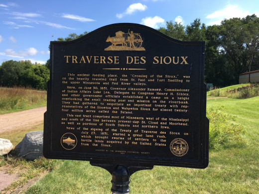
Traverse Des Sioux
On Hwy 169 south of the Twin Cities is Traverse Des Sioux. In 1851, the first treaty between the US government and the Dakota was signed on this spot. The treaty allowed the government to acquire most of the Dakota homeland while paying them a fraction of its value. It also restricted the Dakota to a small swath of reservation land marginalizing the Dakota. Visitors can walk along an interpretive trail to learn more about this treaty and other broken treaties.
Mankato, Minnesota
Not far from Traverse Des Sioux is Mankato, a popular tourist town. It is also where 38 Dakota Indians were hanged in the largest mass hanging in US history. Today in downtown Mankato on the site where the hanging occurred, stands Reconciliation Park, a collection of statues and memorials honoring the lives lost including a large scroll listing the names of all the 38 Dakota warriors who were hanged. This is a must see spot.

Fort Ridgely
Within the boundaries of Fort Ridgely State Park you will find the actual Fort Ridgely. It is accessible by car or, if you’re camping in the park, like we did, it is a short hike from the campground. During the war, Fort Ridgely was attacked twice. At the fort is a tall monument dedicated to those who died defending it.

Lower Sioux Agency
The treaty the Dakota signed confined them to two reservations; Lower Sioux Agency and Upper Sioux Agency. By the summer of 1862, Dakota Indians, were starving because the annual government payment had been delayed and Agency officials refused to extend credit to them. On August 17, frustrations had finally boiled over causing four Dakota men to kill five settlers nearby. The next day, Dakota warriors attacked the Lower Sioux Agency, killing government employees. This action was the beginning of the war.

Birch Coulee Battlefield
Just a few miles from the Agency is the Birch Coulee Battlefield. This is where one of the hardest fought battles of the war took place. The Dakota surrounded US Troops here and pinned them down for 36 hours. Today, the battlefield is preserved mush as it looked in 1862. There is an interpretive walking path that helps visitors visualize what it was like at the time.

Camp Release
Located off Hwy 212 near Montevideo, you will find a 50 foot tall granite obelisk erected to signify the location where the Dakota warriors surrendered and released the settlers who were being held as prisoners, hence the name Camp Release. The Indians were later moved to Mankato for trial and execution. The remaining Indians, even those who never fought in the war, were banished from Minnesota and the remainder of their land was given to more settlers. An unfortunate end.

The River Valley National Scenic Byway is only one of over 20 different scenic byways throughout Minnesota highlighting different notable features of the state. Each one is unique and worth exploring.


