Leif the Lucky

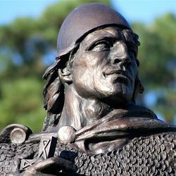
The Man who Discovered America
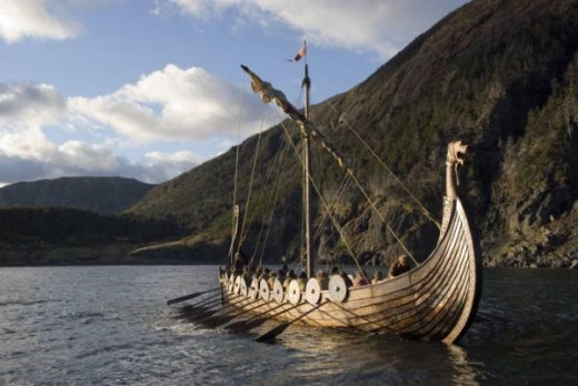
The Vikings were skilled, inventive and thoroughly first rate seafarers.
Of those who made the difficult choice of settling in Iceland, many used the rugged island as a stepping-stone for adventurous westward voyages of discovery. One of the most adventurous was Leif the Lucky.
He was the first European to reach the New World, but his discovery remained unknown to nearly all of Europe for more than 900 years..
Bjarni's voyage inspired Leif
The Greenland Saga tells the tale of Bjarni Herjolfsson, the first European to see North America.
Sailing from Norway to Greenland in 996, he encountered a week of strong northerly wind and fog which blew his ship off course. They sighted the coast of North America but Bjarni didn't land, he wanted to get to Greenland before the end of the sailing season.
His journey inspired Leif to mount his own expedition, so he bought Bjarni's ship and in the year 1002, made landfall in North America. Finding good pasture he called it Meadowland (Vinland).
The Viking Settlement in Newfoundland
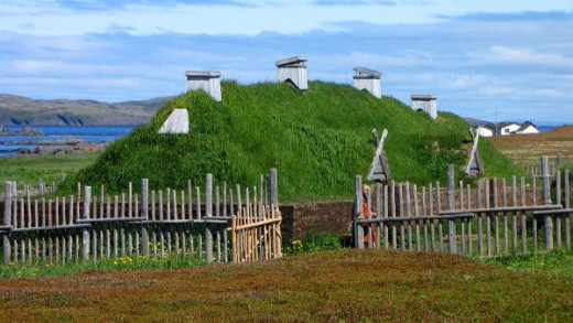
Recreation of Viking lonhouse in L'Anse aux Meadows, photo D.Gordon Robertson
In 1960, the archeological remains of a Norse village were discovered in Newfoundland by the Norwegian explorer Helge Ingstad.According to the Greenland Saga and the Saga of Erik the Red, Leif discovered and attempted to settle land to the west of Greenland. This is the site of Leif's original settlement.
How did Vikings navigate without instruments?
The Vikings had a clear mental picture of the layout of their world. The sun, the moon and the stars showed where they were.
In modern times we use a compass based on magnetism, but they navigated by observing where the sun rose on the horizon and how high it was during the day.
Vikings kept an eye on objects on land as they sailed along the coasts. A rock with a particular shape, mountains or hilltops. Sailors would also listen out for the screeching of birds and the sound of waves breaking on the shore, and they could smell whether or not the ship was close to land..
It's not a voyage I'd like to try. Give me GPS any day.
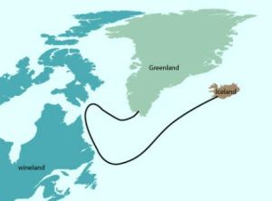
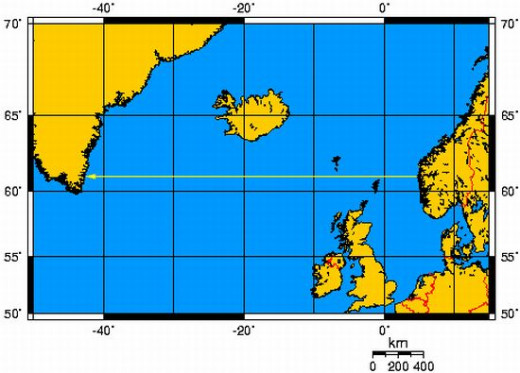
From Norway to Greenland
How did they manage to navigate at all?
Sailing directions for Greenland are listed in the Landnamabok, a 12th century account of the discovery and settlement of Iceland.
To get to Greenland, the Vikings followed the Norwegian coast to Bergen, then sailed due west, maintaining a constant latitude. They passed north of the Shetlands, which were barely visible, and south of the Faroes, where the sea appeared halfway up the mountains. Then nothing but open ocean until Greenland.
The voyage was over 850 nautical miles but even in open ocean, the Viking sailors used whale feeding grounds, concentrations of nautical birds and sea swells as navigation marks..
From Iceland to Greenland
When sailing from Iceland to Greenland, sailors used Snaefell, the highest mountain on Iceland's west coast as a landmark. As they neared Greenland, they looked for the mountain Bla- serkr on Greenland's east coast.
The voyage was about 300 nautical miles but with good visibility conditions , the sailors were out of sight of one mountain or the other for less than a day. Once the destination mountain was spotted on the horizon, course corrections could be made.
Leif sailed in a ship just like this

The Islendingur
The Islendingur, built in 1996 by Gunnar Marel Eggertsson.
Marel sailed her across the Atlantic as part of the millennial celebration in 2000 of his ancestor Leif's voyage to Vinland. On 28 July she arrived at L'Anse aux Meadows, Newfoundland, the single viking settlement to have been discovered in North America and thought to be the site of the Vinland settlement
Further Reading

Since 1964, October 9 is celebrated as 'Leif Eriksson Day'.
Who do you think discovered America?
Who got there first?
© 2014 Susanna Duffy


