Mysteries in History


Mysteries in History
Many events in history are shrouded in mystery. There is quite a long list of historical occurrences that raise a series of questions, and this lens will highlight five such past events that are cloaked in a veil of mystery.
Public domain image courtesy kaxaengabon
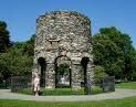
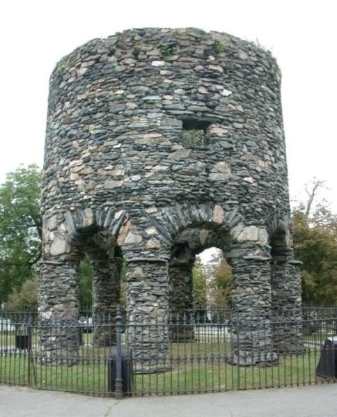
The Newport Tower
The Newport Tower, located in Touro Park (Newport, Rhode Island), is often considered the single most mystifying structure to be found in the United States. Many scholars here and abroad have written extensively about its probable builders. They all agree that it was not erected by the Native American Indians. Its architectural characteristics indicate a style from Europe or the Near East.
Wikimedia Commons photo
Construction and Background
The Newport Tower is located in Touro Park, at the top of Mill Street, surrounded by a historical residential neighborhood on the hill above the waterfront tourist district. Eighteenth-century paintings show that the hill itself once furnished a view of the harbor and would have been visible to passing mariners in Narragansett Bay, but recent tree growth now obscures the view of the harbor from the top of the tower.
The Newport Tower is not exactly circular. From southeast to northwest the diameter reportedly measures 22 feet 2 inches, but when measured from east to west, the diameter lengthens to 23 feet 3 inches, although curiously, 19th century measurements of the interior gave an east-west dimension of 18 feet 4 inches, which was slightly shorter than the north-south measurement of 18 feet 9 inches, suggesting that the discrepancies may be due to the unevenness of the rubble masonry. The tower has a height of 28 feet and an exterior width of 24 feet. At one time the sides were coated with a smooth coating of white plaster, the remains of which can still be seen clinging to the outer walls. It is supported by eight cylindrical columns that form stone arches, two of which are slightly broader than the other six. Above the arches and inside the tower is evidence of a floor that once supported an interior chamber. The walls are approximately three feet thick, and the diameter of the inner chamber is approximately 18 feet. The chamber is penetrated by four windows on what used to be the main floor, and three very small ones at the upper level. Almost (but not quite directly) opposite the west window is a fireplace backed with grey stone and flanked by nooks.
A representation of the tower is featured prominently on the Seal and unit patch of the former US Navy vessel, USS Newport.
Nothing in early Norse architecture is similar, in size or appearance, to the Newport Tower. However, this 17th Century windmill near Chesterton, England, shares many characteristics with the Newport Tower in a document of 1741 the tower is described as "the old stone mill." In this context, "old" is likely to refer to the mill having fallen into disuse, rather than any assumed antiquity of the structure. In 1760 the Tower was used as a haymow, while in 1767 it was described as having been used as a powder store "some time past". De Barres' plan of Newport, published in 1776, marks it as "Stone Wind Mill." During the American Revolution, the tower was used....(read more)
In 1990, radiocarbon dating tests of the tower's mortar supported a construction date between 1635 and 1698.
Tower Virtual Tour
Newport Tower Items


A decimated forest as a result of the Tunguska Event in 1908.
Wkimedia Commons photo
The Tunguska Event was so powerful that the blast it created was felt over 1000 miles away in London, England.
Recent Findings
The 1908 Tunguska event has always been mysterious and intriguing because no one has been able to fully explain the explosion that occurred three to six miles above the Siberian forest. But the latest research has concluded that the Tunguska explosion was almost certainly caused by a comet entering the Earth's atmosphere. And how researcher Michael Kelly from Cornell University came to that conclusion is quite interesting: He analyzed the space shuttle's exhaust plume and noctilucent clouds.
"It's almost like putting together a 100-year-old murder mystery," said Kelley, a professor of Engineering, who led the research team. "The evidence is pretty strong that the Earth was hit by a comet in 1908." Previous speculation had ranged from comets to meteors.
Noctilucent clouds are brilliant, night-visible clouds made of ice particles and only form at very high altitudes and in extremely cold temperatures. These clouds appeared a day after the Tunguska explosion and also appear following a shuttle mission.
The researchers contend that the massive amount of water vapor spewed into the atmosphere by the 1908 comet's icy nucleus was caught up in swirling eddies with tremendous energy by a process called two-dimensional turbulence, which explains why the noctilucent clouds formed a day later many thousands of miles away.
Noctilucent clouds are the Earth's highest clouds, forming naturally in the mesosphere at about 55 miles over the polar regions during the summer months when the mesosphere is around minus 180 degrees Fahrenheit.
The space shuttle exhaust plume, the researchers say, resembled the comet's action. A single space shuttle flight injects 300 metric tons of water vapor into the Earth's thermosphere, and the water particles have been found to travel to the Arctic and Antarctic regions, where they form the clouds after settling into the mesosphere.
Kelley and collaborators saw the noctilucent cloud phenomenon days after the space shuttle Endeavor launched on Aug. 8, 2007. Similar cloud formations had been observed following launches in 1997 and 2003.
Following the Tunguska Event, the night skies shone brightly for several days across Europe, particularly Great Britain - more than 3,000 miles away. Kelley said he became intrigued by the historical eyewitness accounts of the aftermath, and concluded that the bright skies must have been the result of noctilucent clouds. The comet would have started to break up at about the same altitude as the release of the exhaust plume from the space shuttle following launch. In both cases, water vapor was injected into the atmosphere, reinforcing the researchers contentions.
Tunguska Event Clip - History Channel overview on the Tunguska Event.
Piri Poll
Did E.T. help Reis make his map?
Creative Commons image
The Piri Reis Map, written on a gazelle skin in 1513, is the oldest existing map of the Americas.
History and Background
The map was discovered in 1929 while Topkapi Palace was being converted into a museum. It drew immediate attention as it was one of the earliest maps of America, and the only 16th century map that showed South America in its proper longitudinal position in relation to Africa. Furthermore, Piri's claim that he had based some portions of the map on a map drawn by Columbus also drew special attention, as geographers had spent several centuries unsuccessfully searching for a "lost map of Columbus" that was supposedly drawn while he was in the West Indies. After reading about the map's discovery in the The Illustrated London News, United States Secretary of State Henry L. Stimson contacted the United States Ambassador to Turkey Charles H. Sherrill and requested that an investigation be launched to find the Columbus source map, which he believed may have been in Turkey. In turn, the Turkish government complied with Stimson's request, but they were unsuccessful in locating any of the source maps.
The Piri Reis map is currently located in the Library of the Topkapi Palace in Istanbul, Turkey, but is not usually on display to the public.
The map was depicted on the reverse of the Turkish 10 million lira banknote of 1999-2005 and of the 10 new lira banknote of 2005-2009.
Charles Hapgood began studying the map in the middle of the 20th century and published the book Maps of the Ancient Sea Kings in 1966.
Hapgood claims this and other maps support a theory of global exploration by a pre-classical undiscovered civilization. He supports this with an analysis of the mathematics of ancient maps and of their accuracy, which he says surpassed instrumentation available at the time of the map's drafting.
Hapgood argued that owing to the map being assembled from components, the Caribbean section was rotated nearly 90 degrees from the top of South America. He attributed this to either ....(read more)
Map Informational Video

More Map Vids
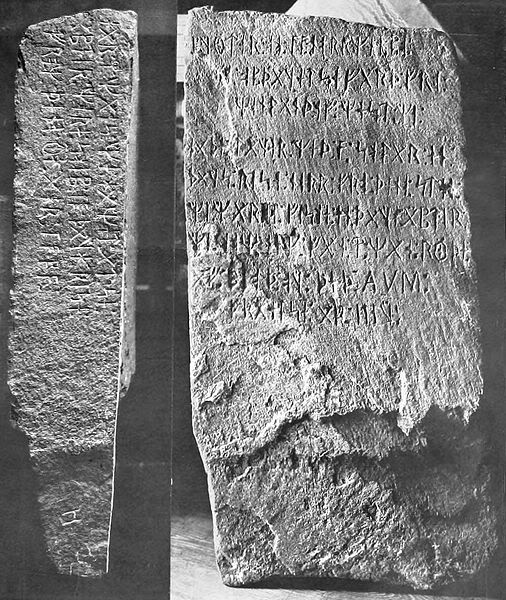
Front and side views of the stone
Wikimedia Commons photo
The Runestone's Background
Swedish American farmer Olof Ãhman said he found the stone late in 1898 while clearing his land of trees and stumps before plowing, having recently taken over an 80-acre parcel that had for years been left unallocated as "Internal Improvement Land". The stone was said to be near the crest of a small knoll rising above the wetlands, lying face down and tangled in the root system of a stunted poplar tree, estimated to be from less than 10 to about 40 years old. The artifact is about 30 x 16 x 6 inches in size and weighs about 200 pounds. Ãhman's ten-year-old son noticed some markings and the farmer later said he thought they had found an "Indian almanac."
Unfortunately for provenance purposes, only family were said to be witnesses to the finding, although people who later saw the cut roots said that some were flattened, consistent with having held a stone. Also, there are many different versions describing when the stone was found (August or November, right after lunch or near the end of work for the evening), who discovered the stone (Ãhman and his son; Ãhman, his son and two workmen; Ãhman, his son, and his neighbor Nils Flaten), when the stone was taken to the nearby town of Kensington, and who made the first inscriptions that were sent to a regional Scandinavian language newspaper.
When Ãhman discovered the stone, the journey of Leif Ericson to Vinland (North America) was being widely discussed and there was renewed interest in the Vikings throughout Scandinavia, stirred by the National Romanticism movement. Five years earlier a replica Viking ship had been sailed from Norway to Chicago for the World's Columbian Exposition. There was also friction between Sweden and Norway (which ultimately led to Norway's independence from Sweden in 1905). Some Norwegians claimed the stone was a Swedish hoax and there were similar Swedish accusations because the stone references a joint expedition of Norwegians and Swedes at a time when they were both ruled by the same king. In Minnesota, Scandinavians were newcomers, still struggling for acceptance; the runestone took root in a community that....(read more)
Kensington Query
Is the Runestone a true historical artifact?
Runestone Readings


Kensington Stone Background Vid
Photo courtesy flickr
The Delhi iron pillar is a truly remarkable testimony to the high level of skill achieved by ancient Indian iron-smiths.
Background
The Iron Pillar, 22 feet tall and weighing approximately 6.5 tons, is made up of 98% wrought iron of pure quality. The Iron Pillar of Delhi is considered a tribute to Lord Vishnu, the patron deity of the Gupta kings and it is believed that once a figure of Garuda, phe carrier-bird of Vishnu!2C crowned the capital of this slender pillar. The inscriptions mention that the pillar was originally located at a place called Vishnupadagiri and historians have identified this place as modern-day Udayagiri.
But how and, more importantly, why the Iron Pillar was later relocated to Delhi remains a question shrouded in mystery. Even the amazing rust-resilient nature of the pillar had been a baffling riddle for archeologists and metallurgists. However a recent study, the IIT Kanpur explains how the pillar's resistance to corrosion is due to a passive protective film at the iron-rust interface. Nevertheless, the Iron Pillar of Delhi is a glowing testimony to the virtuosity of ancient Indian iron smiths.
Iron Pillar Video
Iron Pillar Items

Photo Credits
Unless noted, photos are: Creative Commons, Wikimedia Commons, Wkipedia, and public domain.


