Reading: Waterfront Trail and Greenway Mapbook, Mississauga, Ontario: Dun-Map Inc., a Review


Fine feature of Canada's most populous province
Waterfront Trail and Greenway Mapbook, Mississauga, Ontario: Dun-Map Inc., 3rd Ed., 2009, ISBN10 1-894955-20-X / ISBN13: 978-1894955201, p. p. 104
...
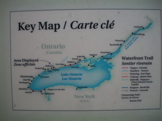
Not only is this a book of fascinatingly detailed maps, it contains much information of great interest relevant to one of Ontario's most remarkable of features: the 730 kilometre path which leads from the US border at the mouth of the Niagara River on Lake Ontario, along the Canadian side of the Lake, and thence to the border with Quebec.
I was intrigued and absorbed by the clarity and the detailed nature of this valuable publication; (admittedly my personal interest may have been heightened by the fact that I live in a city on Lake Ontario through which the Waterfront Trail passes).
One of the really striking features of this book is that localities, presented back to back — many of which are familiar to me — are covered over the course of this very long Trail.
Some of the Waterfront Trail passes through some very historic areas of Canada, rich in Canadian history: these include Niagara-on-the-Lake, Kingston, and Prescott. Along much of the Trail, the path runs directly alongside Lake Ontario, making it almost unfailingly scenic also, and when Lake Ontario gives way to the St Lawrence River and Seaway the Trail enters one of Canada's most beautiful areas.
The editors of this publication have supplemented their content with material from the Waterfront Regeneration Trust.
Helpfully, the book divides the Waterfront Trail into various, regional sections, and within each of these areas suggests a number of itineraries, ranging from the very short to the long.
In the maps, a helpful detail lies in that, where the terrain does not allow for bicycles to go along the part of Waterfront Trail closest to the lakeshore, an alternative path somewhat inland is also suggested.
The Trail's variety and continuation into Quebec
The Waterfront Trail's connection to and continuation with la Route Verte beyond the Quebec border is pointed out. The sheer extent of the Trial is underlined by a listing on p. 103 of the many municipalities and conservation authorities through which the Trail passes, with many marshlands parks with opportunties for bird-watching and nature enjoyment. From the Regional Municipality of Niagara to the Township of Glengarry, they are a reminder of the size and variety in Canada's most populous province.
In places, I found the print somewhat small for my eyes; but whether or not the average reader would have difficulty I am not qualified to say.
June 24, 2013
MJFenn is an independent writer based in Ontario, Canada.
Other of my hubpages may also be of interest
- Reading: Tracy Hanes and Betty VanHoogmoed, Niagara Region, Oshawa, Ontario: Marco Polo Imp.; MapArt
- Reading: Roderick Stewart, Wilfrid Laurier: A Pledge for Canada, Lantzville, BC: XYZ Pub., 2002: a R
- Reading: General Rick Hillier, A Soldier First, Toronto, Ontario: HarperCollins Publishers, Ltd., 20
- Reading Peter Edwards, Delusion: The True Sory of Victorian Superspy Henri Le Caron, Toronto, Ontari
- Reading: Jane Urquhart, L. M. Montgomery, a Review


