Blue Ridge Parkway - America's Favorite Drive

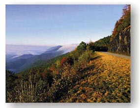
Drives along the Blue Ridge Parkway are intended to be relaxing and conducted at a slow pace. The road is primarily thought of as a scenic byway, but it is also a trek through Appalachian mountain history. Visitors can get a feeling for the history of Appalachian culture through the visitor center exhibits, historic structures, and overlook signs. The Parkway, which meanders for 469 miles, connects the Great Smoky Mountains National Park near Cherokee, NC with the Shenandoah National Park near Waynesboro, VA.
The Blue Ridge Parkway is both a National Parkway and an All-American Road. It is the longest and narrowest National Park in the world and is visited more than any other part of the United States National Park System. Land along the highway is maintained by the National Park Service. Many areas are protected by the United States Forest Service.
Originally called the "Appalachian Scenic Highway," construction began during the administration of President Franklin D. Roosevelt. Work began in September 1935 near Cumberland Knob, NC. Construction on the Virginia portion was started the following February. In June of 1936, the projected was authorized by Congress as the "Blue Ridge Parkway," and became part of the jurisdiction of the National Park Service.
Some of the road construction was done by the Works Progress Administration, and various agencies associated with the New Deal were responsible for part of the work. Landscaping and the development of recreation areas were carried out by the Emergency Relief Administration. Civilian Conservation Corps personnel assisted with grading, the improvement of adjacent land, planting, and roadside cleanup. Construction took over 52 years to complete. In 1987, the last stretch around Grandfather Mountain was accomplished with the completion of the Linn Cove Viaduct. The parkway includes 27 tunnels, 168 bridges, and 6 viaducts.
The Blue Ridge comes alive with flowers from the early spring through the summer. The blooming of the Dogwoods, Azaleas, and Rhododendrons adds a special beauty to the already scenic route.
Four lodges and six restaurants are scattered along the Parkway. Most of these operate from late April through the fall color season. Many of the communities adjacent to the Parkway offer regional cuisine.
The weather conditions can vary tremendously on the Parkway depending on the elevation. The highest point on the parkway, south of Waynesville and near Mount Pisgah in North Carolina, is 6047 feet above sea level. Inclement weather sometimes forces the closure of particular sections due to fog, snow, or freezing rain.
Short side roads are used to connect the Parkway with larger highways. There are entrances and exits near all the major state and federal highways. However, no direct interchanges with interstate highways were created, making it possible to enjoy the scenery and wildlife without stopping for crossing traffic. Asheville (where the Parkway crosses part of the Biltmore Estate property), Boone, and Mount Airy in North Carolina and Roanoke, Galax, and Waynesboro in Virginia are the largest cities near the Parkway. In Virginia, Interstates 64, 81, and 77 all have directions for accessing the Parkway. In North Carolina, this is also true for Interstates 40 and 26, and U.S. Highway 52.
Milepost markers along the Parkway start at zero at the northeast end of the Virginia section and increment up to 469 at the southern end in North Carolina. The mileposts, which note points of interest and scenic overlooks, can be found on the west side of the road.
For some points of interest along the Blue Ridge Parkway in North Carolina, click below:
Blue Ridge Parkway - North Carolina Points of Interest


 in Western North Carolina")


