Why your GPS is sometimes wrong

Global Positioning System
The Global Positioning System
The Global Positioning System (GPS) comes standard in a wide range of items; mobile phones and cars just to name two. They are small and relatively inexpensive (as an aside, when I was an Army surveyor in the 80s, our GPS units needed a Landrover to carry them and cost about $250, 000) and we have come to rely on them to find our way around.
But many of s will have come across that odd time when technology lets us down. The story the GPS was telling us wasn’t quite right. So how can a system with such a remarkable inherent accuracy lead us up the garden path? The truth is, it’s probably not the GPS that’s the problem, it’s the map behind it.
To better understand the relationship between the GPS and the graphic display we need to go back and look at some of the cartographic (and geodetic) basics. The following information is a very brief overview of what is going on inside your system.
The Earth’s Shape
One of the biggest problems facing anyone wanting to map the Earth is the fact that it is inconveniently not flat. Throughout history cartographers have grappled with the question of how to map such an odd shape. Over time, map makers came to recognise three basic models of the Earth.
Its true Shape While we think of the Earth as round, in reality it‘s an oblate spheroid, that is, flattened at the poles and bulging at the equator. To add to the confusion it has a very uneven surface with high mountain ranges and deep oceans; all in all, not a very good surface to lay a map grid out on.
The Geoid This is a theoretical surface that roughly corresponds with sea level. To be more precise, it is an equipotential surface where gravity and centrifugal force are constant. While it is much better, it too has its problems. Since gravity is driven by mass, where the Earth is denser, gravity is greater. Hence the geoid has dips and bumps that are difficult to model. We needed a more regular shape.
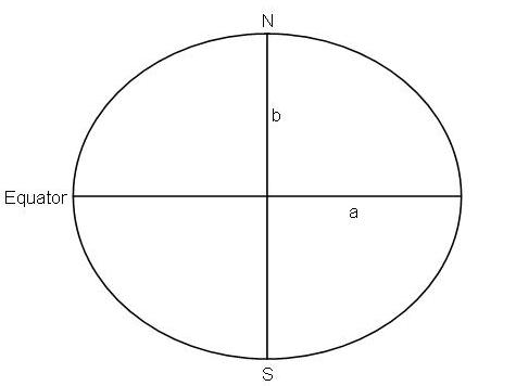
The Spheroid Sometimes called the Reference Spheroid, this is a mathematical surface created by rotating an ellipse (oval) about its north and south axis. It is defined by the length of the radii from the Earth’s centre to the poles and the equator. In the diagram, a is the semi-major axis and b is the sem-minor axis. This produces a very even and regular surface however it does depart from the true shape of the Earth enough to introduce some error.
Differing Spheroids
If all this isn’t confusing enough, if we look at maps from different parts of the world, we will find a number of different spheroids have been used. To understand why this is we need to go back to the true shape of the Earth. Basically it is like a big lumpy potato. Before we were able to map the world in one go, cartographers had to do it a piece at a time. As each continent was mapped, a spheroid was developed that best fitted the area. Picture it as mathematically jiggling the spheroid until it coincides, as best as possible, with the surface of the Earth. The variations were made to the length of the axes creating a slightly different sized model. Once the shape of the area was determined, cartographers could set about drawing maps that best represented their area of responsibility.
Finally, thanks to the advent of satellite positioning systems (there were others before GPS) we were able to develop a spheroid that was a best mean fit of the entire planet.
How does the GPS work?
To put it in very simple terms (more detail in a later hub) the GPS works by measuring the time taken for a signal to get from the satellites to the receiver. As the position of the satellite is known, a distance to the location can be calculated. By using four or more satellites, a position can be determined with great accuracy. At this point, the location is identified using Cartesian Coordinates which are X, Y and Z coordinates from the Earth’s centre. The GPS equipment then converts the position to latitude and longitude based on the spheroid selected by the user.
Sources of error
So what does all this mean to the user? Well, there’s going to be a problem if the map doesn’t match the coordinates from the GPS. In Australia, the difference between the World Geodetic System and the Australian Geodetic Datum is about 180 metres. The map itself, however, is a haven for error. After all, you’re trying to fit a big round thing on a small, flat sheet of paper (or screen). So if you do find that the GPS puts you in a place where you can clearly see you are not, the reason could be one of the following:
· The cartographer got it wrong
· Distortion from the map projection
· Detail on the ground has changed (roads, fences, new dams etc)
· The map was made from low precision source data
· Shrinkage and stretching of a paper map
· Poor printing
· The base map was not aligned correctly with the true coordinates
The information I have given you so far is a bit of a ramble. It is meant as a very brief introduction
To really get the best out of your Global Positioning System it helps to understand what a map really is and what it represents. You should know enough to be able to recognise when something is wrong.
More info on maps
Reference Spheroid
")


