Atlantic Ocean Road - A Spectacular Norwegian Construction Marvel

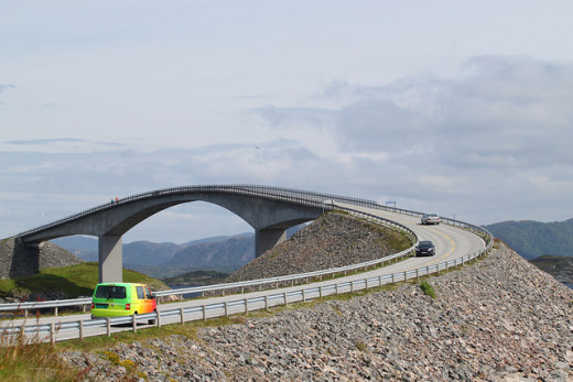
Storseisundet Bridge at Atlantic Ocean Road
During my last visit to Norway as a student about two decades back I was highly impressed by the stunning scenic views and landscapes of Norway. A mountainous country kept me engaged in road journey with snow all around which proved mesmerizing for me as well as my classmates. Our schedules did not permit us to enjoy the fjords which are known to present gorgeous sceneries along coastal areas and are major tourist attractions in Norway.
Environmentalists place Norway among a few top countries which have implemented policies for maintaining harmony between nature and development. By abandoning the idea of laying a railway line, conceived in early twentieth century, due to a mix of complexities and environmental issues and replacing it with an impressive road for connecting the island and Municipality of Averoy with mainland of Eide, towards the last decade of the century, the country has shown its will to exhibit successful interaction between people and nature.
In this process Norway has created one of the most impressive roads known as The Atlantic Ocean Road (called Atlanterhavsveien in Norwegian) which has become top tourist attraction in the world today.
Stay with me to have a trip and a close look at the world's most spectacular route which is an amalgamation of architectural marvel and nature.
The Atlantic Ocean Road

Describing The Atlantic Ocean Road
The Atlantic Ocean Road is 8.3 kms long which is built across islets and skerries. The linkages are created by causeways, viaducts and bridges. There are eight bridges and four resting place in this stretch of the road.
The road was completed in July 1989 after facing 12 hurricanes.It has been awarded as 'Norwegian Construction of the Century' and also declared as Culture Heritage Site,
The heights and lengths of the bridges are presented in the table below:
Details of 8 Bridges
Name of the Bridge
| Length
| Height
| Remarks
|
|---|---|---|---|
Vevang Stream Bridge
| 119 meters
| 10 meters
| |
Hulvågen Bridges (3 Bridges combined)
| 293 meters
| 4 meters
| Longest Bridge
|
Storseisundet Bridge
| 260 meters
| 23 meters
| Highest Bridge
|
Geitøysundet Bridge
| 52 meters
| 6 meters
| Shortest Bridge
|
Store Lauvøysund Bridge
| 52 meters
| 3 meters
| Shortest & Lowest Bridge
|
Little Lauvøysund Bridge
| 115 meters
| 7 meters
|
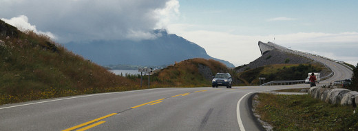
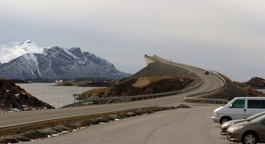
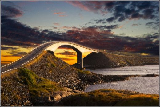
Storseisundet bridge - The Most Prominent
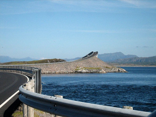
The Atlantic Road can be considered one of the most scenic route of the world and the Storseisundet Bridge adds to its scenic value. This is the longest of the eight bridges and the shape of the Bridge goes on changing as one drives along the road. It marks the boundaries between Eide and Averoy Municipalities.
Storseisundet bridge - Where would you go from here?
Have a Breather
On reaching this spot one feels as if it is the end of the road at the top and wonders where all these speeding vehicles will be landing. Will these land into the Norwegian sea directly?
Just before reaching the top there is a space where one can rest and have magnificent views from different angels and proceed further. It is also popularly called “The road to nowhere”
Closer View
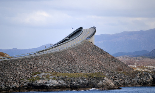
This cantilever bridge is 260 meters long and 23 meters high. The visibility of the curve while nearing the top ends the optical illusion created by its shape seen from different positions. It gives a hope to the person approaching the top and one gets the sensation of going somewhere.
The maximum gradient on the road is 8% only and roller coaster feeling at the top vanishes on this systematic descent.
Normal View
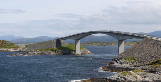
And it looks like any other bridge from a different angle.
Other Bridges
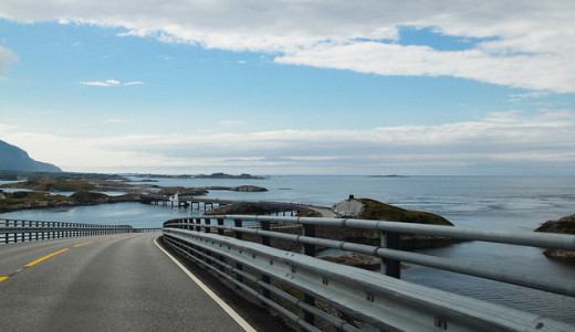
As one goes along other smaller Bridges follow.
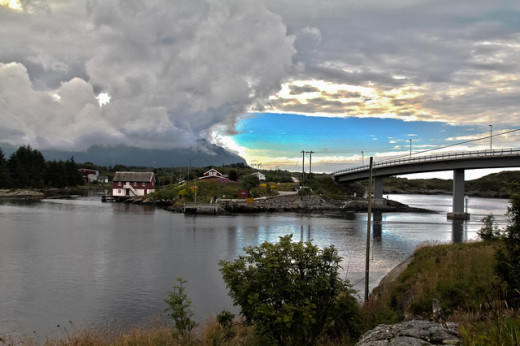
Changing scenes with changing weather
Motocycle Adenture
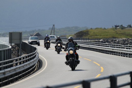
Many tourists can be seen riding motorbikes and enjoying the ride on this wonderful serpentine road. When the sea is calm during spring and summer, it could be the most enjoyable journey. But sea is rough at times and it is a real adventure to perform this journey on motorbikes during autumn and winter. Crashing of strong waves of the rough Norwegian Sea can be scary for travellers on pavements and while driving but it continues to be a popular drive for tourists.
Have a look how dangerous it can be in the following video:
Is the journey dangerous also?
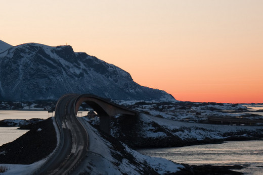
Some views during different seasons
How much difference can the time of the day make in the appearance of this Bridge?
Changing looks in changing weather
Snow clad
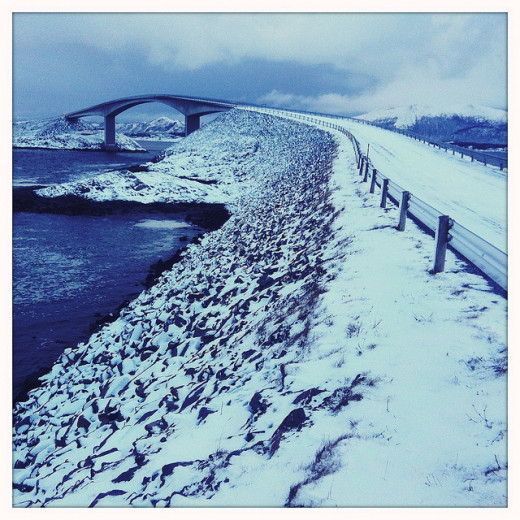
Looks gorgeous during snowing season.
Additional Highlights
- During calm weather one could see whales (if one is lucky) and seals. There is a dramatic change in the situation during rough weather.
- Wonderful birds watching is another pastime activity which many tourists enjoy during this 8 kms journey staring from Kristiansund and ending at Averoy.
- The primary purpose of constructing the Road may be linking coastal communities, which seems to be greatly served but it has assumed importance because of the architectural excellence.
- Apart from the drive the tourists enjoy picnic spots and have the provision of walking a few meters for enjoy fishing. One of the bridges is specially designed for the purpose of fishing.


")