- HubPages»
- Travel and Places»
- Visiting North America»
- United States»
- Arizona
An Enjoyable Hike to the Historic Presidio Santa Cruz de Terrenate

Off to See the Remains of a Spanish Frontier Fort Built in 1776
After spending a recent weekend morning climbing and exploring the spectacular rock formations in Texas Canyon my wife, son and I headed south in search of the crumbling remains of a two and a half century old Spanish fort located on a remote bluff above the San Pedro River in the Southern Arizona desert.
Texas Canyon is located just off Interstate10 near the little town of Dragoon in Arizona’s Cochise County. Our destination was toward the lower part of the San Pedro Riparian National Conservation Area (NCA).
The San Pedro NCA is a 57,000 acre block of land that extends along the San Pedro River from the Mexican border north to the town of St. David, AZ.
This area is managed by the U.S. Bureau of Land Management and consists of public and private lands managed with the intent to conserve and protect the ecosystem supported by the San Pedro River as it flows north from Mexico through the Chihuahuan and Sonoran deserts in Arizona. The San Pedro Riparian NCA is a popular location for hiking, bird watching and other outdoor activities.
The San Pedro Riparian NCA also includes a number of ghost towns and the fragile remains of an old Spanish fort known as Presidio Santa Cruz de Terrenate which was the objective of our afternoon hike.
Welcome To Presidio Santa Cruz de Terrenate

Driving Directions to Presidio Santa Cruz de Terrenate Trailhead
Presidio Santa Cruz de Terrenate is located about 95 miles southeast of Tucson, Arizona.
To reach the Presidio from Tucson take Interstate 10 east to exit 302 and turn right from the exit ramp on to Arizona Highway 90 south toward Sierra Vista, AZ.
Map Showing Presidio Santa Cruz de Terrenate in Relation to Tucson International Airport

GPS Coordinates for Presidio Santa Cruz de Terrenate
Travel south on Highway 90 about 19 miles to the intersection of Highway 90 and Arizona state highway 82. Turn left onto Highway 82 heading east. Continue about 12 miles along Highway 82 to N. Keller Rd.
As you travel along Highway 82 you will pass a large sign announcing that you are entering the San Pedro Riparian National Conservation Area - N. Keller Rd is not far from this sign (and if you pass a second large sign informing you that you are leaving the San Pedro Riparian National Conservation Area, turn around as you will have passed N. Keller Rd. The San Pedro Conservation area is only a few miles wide).
At N. Keller Rd. there will be a small sign indicating a left turn onto N. Keller Rd. for Presidio Santa Cruz de Terrenate.
A little less than 2 miles after turning onto N. Keller Rd there will be a sign to turn right for Presidio Santa Cruz de Terrenate. Less than a mile after this there will be a “T” intersection indicating a right turn for the Presidio. Less than a half mile after this you will arrive at the parking lot by the trail head.
Parking Lot and Trail Head

Things to Consider Before Starting Your Hike to Presidio Santa Cruz de Terrenate
The final stage of your visit to the Presidio Santa Cruz de Terrenate has to be on foot along a mile and a half long hiking trail through the mostly chaparral (a green bush also known as greasewood) covered desert. The trail is mostly flat and easy to follow.
Our Son on the Trail

Checklist for the Hike
Things to bring with you for the hike:
- Comfortable shoes with thick soles (no sandals or other open shoes
- Small backpack, fanny pack or other strap on carrying devices
- Water
- Snacks
- Sun screen
- Hat (especially if you are balding)
- Sunglasses
- Camera
This is a high desert valley about 4,700 feet above sea level (Tucson is about 2,300 feet above sea level). Our visit was at the end of August and the summer temperature was eight to ten degrees cooler than than in Tucson.
While it is a relatively easy and comfortable hike, common sense precautions are necessary. A mile and a half from the parking lot to the Presidio is an easy walk for the average healthy person, just remember that it is also another mile and a half back from the Presidio to your car and the nearest road. Keep this in mind especially if you have young children or older people hiking with you.
Chaparral as Far as the Eye Can See
 with Huachuca Mountains in the distance")
Even though the temperature in this high desert area is cooler than in lower desert areas and the area is completely covered with lush green vegetation, it is still desert and there are no drinking fountains or water sources anywhere in the immediate area. So bring sufficient water with you.
Trail to Presidio Santa Cruz de Terrenate

Some food (granola bars, fruit, etc.) is optional but a good idea - just remember to hang on to any containers, wrappers, orange peels, banana skins, etc. and deposit them in the trash containers at the trail head when you return.
Hats, sunglasses and good comfortable walking shoes (hiking boots are good but not necessary if you don’t own a pair). Sunscreen is a must even on overcast days. The ultra violet rays (which cause sunburn and skin cancer) can not only penetrate clouds but are more intense at higher altitudes. There is no shade along this trail.
A Beetle Standing on its Head

A Beetle Standing on Its Head in Middle of Trail
Except for a few birds in the distance and a lone beetle on the trail, we didn't see any wildlife in the area during during our afternoon hike.
The beetle in the photo at right was in the middle of the trail and appeared to be busy attempting to stand on its head. I stopped to watch him and, when it finally succeeded in standing on his head and holding it like some yogi practicing the sirsha-asana (headstand), I snapped this picture of it..
I then continued my hike leaving the beetle doing whatever it was that reqiured standing on its head.
Relaxing & Enjoying the View

The hike to the presidio is an easy mile and a half walk along a flat area surrounded by mountains in the distance. The first part of the hike is along a narrow path in the midst of a vast sea of chaparral - small green shrubs which are also called greasewood.
Small signs along the trail indicate the remaining distance to the presidio. The trail through the chaparral ends at a small, rocky wash that passes under an arched bridge of an old railroad bed to the left of the trail.
Old Railroad Bridge Over Rocky Wash - Take Path to Left of Bridge & Turn Right at Top to Continue To Presidio

Climb to Railroad and Turn Right to Continue to Presidio
There are signs directing hikers to turn left and climb the small hill to the railroad bed. At the top of the small hill there is one sign with an arrow pointing back to the trail through the chaparral to the trail head. This is great for those returning from the presidio but there is no sign indicating which way to turn on the railroad bed for the presidio.
You should TURN RIGHT at the old railroad bed at the top of the small hill. Then proceed down the black cinder railroad bed (the tracks have been removed.
There will be one more sign a quarter mile from the presidio.
The presidio itself is to the left of the railroad bed. You will know when you arrive as there is a restroom on the right side of the railroad bed and a large, national park style, sign on the left welcoming people to the historic site.
Restroom Across From Entrance to Area Containing Ruins of Presidio Santa Cruz de Terrenate

Stay on Trail in Ruins Area or You May Miss Them
Signs along the narrow, half mile trail through the site direct visitors to stay on the trail so as not to damage the fragile environment.
It is a good idea to stay on the trail, not only to protect the site, but also to avoid spending time wandering around the area and even passing within a few feet of the ruins without ever seeing them.
Remains of Commandants Quarters in Presidio Santa Cruz de Terrenate

Two and a Half Centuries Later Not Much is Left of Presidio Santa Cruz de Terrenate
While the sign at the parking lot by the trail head and other articles about Presidio Santa Cruz de Terrenate describe it as the most intact example remaining of a once extensive network of similar fortresses that marked the northern hegemony of Spain into what is now the State of Arizona, the fact is that the ruins at this site consist of a few partial adobe walls.
Marker Honoring and Remembering Spanish Soldiers Defending Presidio Santa Cruz de Terrenate
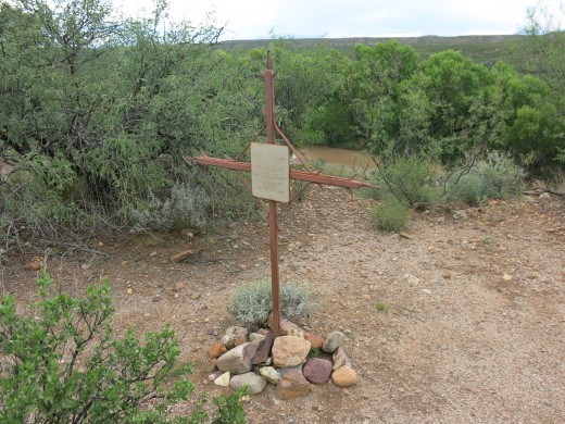
Text on Marker Honoring Spanish Soldiers Who Gave their Lives Defending the Presidio
Real Presidio de
Santa Cruz de Terrenate
1776-1780
Muerto en Batalla
(Killed in Action)
7 July 1776
Capt. Francisco Tovar
29 Soldados
24 Sept. 1778
Capt. Francisco Trespalacios
27 Soldados
Nov 1778 - Feb 1779
39 Soldados
May 1779
Capt. Luis del Castillo
Placed by
Warrant Officers of Fort Huachuca
Bluff Overlooking San Pedro River and Huachuca Mountains in Distance

Is an Easy and Enjoyable Hike Despite Lack of an Intact Fort
Visiting Presidio Santa Cruz de Terrenate is an enjoyable and easy hike through some beautiful country. The Presidio itself is located on a high bluff that provides a spectacular view of the the San Pedro River below. The bluff upon which the ruins of the Presidio sit provides a good view of the river and surrounding area.
History buffs who enjoy standing on land on which a great event in the past took place but today is marked only by a sign will enjoy visiting this Presidio as the land not only contained a fort and was the site of ferocious battles over two centuries ago but also has a few small fragments of the old Presidio still standing. For those who are not history buffs what little is left of the Presidio will be a great disappointment.
However, both history buffs and those who have no interest in history will still enjoy the hike to the site of the historic Presidio.


