How to stop "Are We There Yet?" questions on a long road trip

Introduction
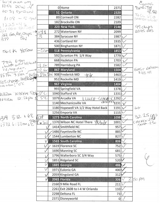
Last December my family drove to Disneyworld from our home in a suburb of Montreal. We picked a hotel about five sevenths of the way down to act as an interim rest point as travelling with kids requires this.
I came up with an idea of how to keep the kids somewhat entertained as we traveled the many miles it would take to get there. In a nutshell it is a chart that shows a bunch of interim towns along the way that they can check off as we are travelling.
Preparing the chart
Before going on your road trip, use Google Maps, or any other mapping website or software you have and find out what the total distance is of your trip. Now divide that total distance into between 25 and 40 sections (ie a shorter road trip will take fewer sections). So let's say the trip is 4000 miles, I would divide that up into 40 sections of 100 miles each. Now, from your starting position, look for the town that is roughly 100 miles away, and take a note of the name of the town as well as the mileage marker from the start. From that town, look for the next one that is roughly 100 miles away and take a note of the mileage marker for that town. Continue like this all the way to your destination.
I did this and saved it in a spreadsheet that had one other empty column to write the temperature. Our Grand Caravan has a temperature gauge that is easily visible to all of the occupants of the van so, since we were travelling from Montreal to Florida in December, there would be a significant difference in temperatures as we traveled.
I also included the reverse markings for the return trip. For a future trip I would add a few extra empty columns to write down the actual mileage recorded in the van, the time of day (or night) that we reach each town and any other information we might want to track.
Using the chart
So as we drove the kids will no longer be asking, "Are we there yet?" but rather, "are we at X town yet?" In this way the kids can track the progress of the road trip and will have a much better idea as to how much more travel there is based on their chart and how many empty rows there are.
Other notes the child can write on the chart are things like places that we stopped to pee, places we stopped to eat, places we stopped just for gas and so on. The child can also use the margins of the page to write anything else they might see along the way, like a large group of cows, or a falcon that was circling above the highway, or a train of sixteen identical shipping trucks.
Keeping the chart
Once we got home from the vacation we were able to keep those pages and add them to the trip's scrapbook as a record of the journey to and from Disneyworld. My two oldest children were really happy to have this page as it really helped them to understand how long it would take to get there and it gave them a sense of anticipation as we got closer. My youngest at just under two years old had no appreciation for this, as you can well imagine.