Main Waterfalls in Sri Lanka - part 2

Huluganga Falls
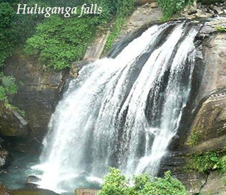
Huluganga falls is located at huluganga town, about 30km away from Kandy in on the way of bambaraella, in Kandy district in central province. Hulu River is originating from the knuckles mountain range. Hulganga falls is about 75 meters in height. The cascading water sprinkles the villages of elliyadda and arattnana, before flowing to the Victoria reservoir. There are lots of rocks on the river and even on the rainy days the water does not get muddy because of rocks, grass and plants, as well as less environmental pollution. Since the annual rain fall received by the catchments area of the fall is high, it is ever young throughout the year.
Dunhinda / Kuda dunhinda Falls

Dunhainda falls is a waterfall located about 5km from badulla town I uva province. The Dunhinda falls is one of the Sri Lanka’s most beautiful waterfalls. The waterfalls, which is 63 meters high, gets its name from the smoky dew drops spray, which surrounds the area at the foot of the waterfall. The waterfall is created by the river called badulu oya which goes through the badulla town. To reach the water fall you have to walk more than 1km distance along o foot path. Along this foot path you can see another small waterfall called “kuda dunhinda” at a distance. (In Sinhalese kuda means small) At the end of the path there is a secure stage constructed for views to see the waterfall. Downsides of dunhinda there are 3 main water valleys called randenigala, rantabe and theldeniya. Uma oya direct to rantabe and other 2 valleys from Mahaweli River from Kandy.
Hunnas Falls
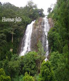
Hunnas waterfalls is located about 22km from Kandy town in central province. However this is located in mathale district, elkaduwa village. There are two roads to reach hunnas waterfall. One is coming from mathale to elkaduwa, the other is wattegama (Kandy) to elkaduwa. Hunnas falls, which derives its name from hunasgiriya peak, the forest covered mountain which overlooks this tranquil landscape. The knuckles mountain range extends up to matale the hunnasgiriya is located at one end, 1765 meters above sea level. This are is subject to every climatic condition of the island. A group of five streams flow from here and meet to from the maha oya reservoir, which leads on to hunnas falls (48 meters high and 12 meter wide) and the Suduganga River. This waterfall is 60 meters in height and created by a stream from hunnasgiriya peak. Apart from the main fall several streams can be seen during rainy seasons.
Nanuoya Falls
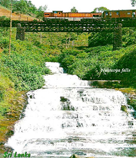
From the Nanu Oya River, the water flows through the udaradella and bambarakelle areas to the fall. The water cascades through mist down a sequence of 25 steps and later joining the kotmale and Mahaweli River. A hint of grandeur id added to the scene by the imposing bridge that spans the fall. The fall situated in nanu oya, 6km from nuwaraeilya in central province.
Bopath Ella
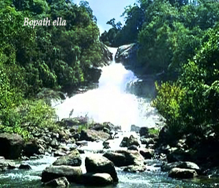
Bopath Ella is a waterfall situated in the ratnapura district in sabaragamuwa province. The waterfall is major tourist attraction in the country. Local myths say that it is haunted and that it hides a treasure trove. The name “bopath ella” has been given to the waterfall because of its shape. The water flows through a narrow gap in the rocks and then widens, forming the shape of leaf of a “bo” tree which is the Sinhalese name for sacred fig. (Ficus religiosa). “path” means leaves of a tree and “ella” means waterfall. Virgin forests with a rich biodiversity surround the waterfall. Bopath ella is 30meters high. It is formed from the kuru ganga, which is a tributary of the kalu ganga. Its mean rate of flow is 6 square meters per second, and its catchment area receives an average rainfall of 5080 mm annually
Ravana Ella
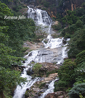
The ravana ella is a popular sightseeing attraction in Sri Lanka. It currently ranks as one of the widest falls in the island. It located at ella-wellawaya road in uva provice.This waterfall measures approximately 25 meters in height and cascades from an oval-shaped concave rock outcrop. During the local wet season, the waterfall turns into what is said to resemble an area flower with withering petals. But this is not the case in dry season, where the flow of water reduces dramatically. The falls have been named after legendary Hindu character ravana, which is connected to the famous Indian epic, the Ramayana. According to legend, it is said that ravana (who was the king of Sri Lanka at that time) had kidnapped princess sita, and had hidden her in the caves behind this waterfall, now simply known as the ravana ella cave. At the time, the cave was surrounded with thick in the midst of wilderness. It is also believed that Rama’s queen bathed in a pool that accumulated the water falling from the waterfall.
Galboda Falls
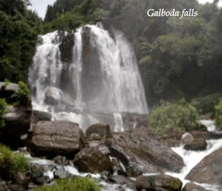
Another beautiful waterfall in Sri Lanka. It is located by nawalapitiya, nuwara-eliya district in central province. Galboda is nice station along the railway track of Colombo – badulla. There is so much nature scenery and animals. The environment is very cool with much rain. This waterfall is higher than 30meters, but the width ranges from between 3-6 meters, depending on the season with distance of 1-2 km from the railway station, known as galboda waterfall. Since the area is closed to watawala where the highest rain fall is received out of the country, the waterfall is ever young. The name of the fall (fall adjoining the stone) is said to derive from the large boulder situated at its foot, through another theory is that the water here is heavier than anywhere else on the island. At certain times of the year, the water also cascades in 2 streams. Growing in the surrounding woodland is a rare species of orchid and the vicinity of wildlife. Among them are 12 species of reptile and 4 are only found in Sri Lanka. The upper section of the fall is unique in its biodiversity, thus it is of paramount importance to limit any potential danger to the area.
Elgin Falls
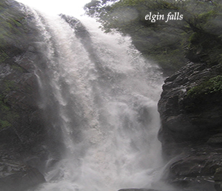
Elgin falls is a waterfall located in the Elgin tea estate which is 18km from the nuwaraeliya town in central province. The waterfall is 25 meters in height. Elgin falls named after Elgin major town of moray in Scotland. The falls is at about 1900 meters above sea level. There several ways to access the waterfall. When travelling by railway between nanu oya and ambewela the falls can be seen picturesquely. Elgin waterways are very pure water consisting one. Bath in Elgin and close to Elgin is somewhat difficult task. Because not a clear path to close to the falls. Downside of the falls there is a village and single line railway station called “parakumpura”. Dayagama ambewela, pattipola and closed area of the waterfall is very much suitable to cultivate potatoes.
Handapan Ella
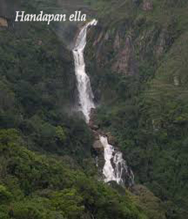
The Handapan Falls, springs from the 23 meters high handapan falls valley and is the starting point of the Rakwana River. The northern slope of the valley is situated between Kadaragala Mountain and Sinharaja Mountain, ratnapura district in sabaragamuwa province. During the period of the kandyan kingdom, this area was under the rule of chieftain ehelepola nilame. Local villagers believe that his treasure trove is hidden in the fall. From rakwana, take ratnapura-deniyaya road and at the end of buluthota pass, it is a 4km trek along a difficult rocky path to the fall, which is located in the jungle near paluna village. Alternatively, from ratnapura take the road to kalawana via rambukka rajawatte.
Baker's Falls
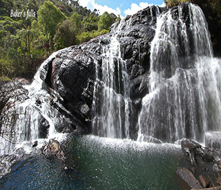
This fall is a famous waterfall in Sri Lanka. It is situated at Horton plains national park (cloudy forest) in nuwaraeliya district, central province. It tributary of the belihuloya. The height of the baker’s falls is 20 meters. Baker’s fall derives its name from Sir Samuel baker, a British man who discovered it in 1845. The baker’s fall in the Horton plains gets its water from the belihuloya. It is close to world’s end. The icy waters glisten in the sunshine amid a backdrop of mountain terrain and deep valleys and the patana through which you traverse give it contrast. Situated on the Horton plains, Baker’s fall is accessible from pattipola or ohiya town. From pattipola take the well-signed footpath and either follows it to world’s end and loop back to baker’s fall or take the right fork at the beginning of the path straight there. Immediately before the fall, there is a steep, root-strewn bank, which can be difficult to negotiate, especially in wet weather.
Main Waterfalls in Sri Lanka - part 1
- Main Waterfalls in Sri Lanka - part 1
This article about main waterfalls in Sri Lanka, This article might be useful for people who travelling Sri Lanka. Readers of this articles can take knowledge about Sri Lankan waterfalls, and their locations.Beautiful Sri Lanka.
Related

The 7 Waterfalls of Mambukal Resort in Bacolod

Sri Lanka Venomous Snakes, Poisonous Spiders, and other Deadly Insects
")
Hanging Rock State Park, North Carolina (Trail Maps and Tips)

Shopping in Sri Lanka - Top Things to Buy as a Tourist

Big Island of Hawaii: A Guide for Solo Travelers Who Seek Solitude and Want To Avoid Crowds


