- HubPages»
- Travel and Places»
- Visiting North America»
- United States
Hiking Rae Lakes Loop - Sequoia & Kings Canyon National Park (California)

Overview
The Rae Lakes Loop is one of the most popular backpacking trips in the Sierra Nevada mountains of California in Kings Canyon National Park. This loop hike is 46 miles long, and climbs from 5035' (1535m) at the trailhead at Roads End to 11,978' (3651m) at Glen Pass. For a period of time the trail joins up with the John Muir Trail and the Pacific Crest Trail.
There are varying lengths of time you can take to complete this trail. This hub will describe the hike taking 5 days/4night, while you can tailor your own trip to spent much more time in the backcountry exploring various valleys or relaxing by Rae Lakes. A friend completed the trail in 2 days/1night, though I would not recommend it if you are looking for a relaxing backpacking trip and/or you are in really good shape and have experience trail running.
This trail can be very popular during the summer months and it is suggested that you send a reservation into the National Park Service for a wilderness permit Wilderness Permit Reservation Application

Getting to Roads End
The Rae Lakes Loop begins at Roads End, near the Cedar Grove Visitor Center and Village. In Cedar Grove Village there is a store; restaurant; rustic hotel (Cedar Grove Lodge); pay showers; and campgrounds.
Coming from San Francisco or Los Angeles take north or south Highway 99 to Fresno. Then take Highway180 east (about 53 miles) to the Big Stump park entrance. Once you've paid your entry fee to the parks ($20.00 entry fee), continue on Hwy. 180 (veer left at "The Wye" towards Grant Grove Visitor Center) for approximately 34 miles until you reach Cedar Grove Village. The drive on 180 from Grant Grove to Cedar Grove is a beautiful, meandering drive following the South Fork of the Kings River. Using the park map given to you at the park entrance you can easily navigate your way to Cedar Grove and identify various services and notable sights. Maps of Sequoia & Kings Canyon National Park
On your way to Cedar Grove you may want to stop at General Grant Visitor Center and view General Grant Tree, which is the third largest tree in the world and was named the "nation's Christmas tree" in 1926 by President Coolidge. On your way to Cedar Grove you can find a gas station at Hume Lake where you will also want to buy your California Fishing License if you plan to fish on the trail. National Park Service information says you can purchase a license at Cedar Grove, but you cannot and I can attest from experience that you will then have to drive back to Hume Lake, which is not fun after a long day of driving.
The drive from San Francisco takes about 5.5 hours and from Los Angeles takes about 5 hours.
Day One - Roads End to Upper Paradise (11 miles)
Leaving early in the morning from either the campgrounds or hotel at Cedar Grove Village you will have to drive to Roads End where you will leave you car for the duration of the hike. There is a permit station at the begining of the trail at Roads End where you will to pick up your wilderness permit.
The trail starts off through a level, open pine forest. After about two miles you will come to a split in the trail
Rae Lakes Loop Map
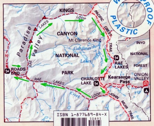
Distances Along the Rae Lakes Loop
Point Miles from Roads End via Paradise Miles from Roads End via Bubbs
Road's End 0 46.0
Paradise/Bubbs Jct. 2.0 44.0
Mist Falls (no camping) 4.0 42.0
Lower Paradise (first campsite ) 6.0 40.0
Middle Paradise 8.0 38.0
Upper Paradise 11.0 35.0
Woods Creek Crossing 17.0 29.0
Dollar Lake 22.0 24.0
Rae Lakes 25.0 21.0
Glen Pass 27.5 18.5
Charlotte Lake Junction 30.0 16.0
Vidette Meadow 32.0 14.0
Junction Meadow 35.0 11.0
Charlotte Creek 38.5 7.5
Sphinx Junction (last campsite ) 42.0 4.0
Paradise/Bubbs Jct. 44.0 2.0
Road's End 46.0 0.0
Fishing on the Rae Lakes Loop
Fishing on the Rae Lakes Loop can add a lot to the experience, in addition to supplementing granola bars and macaroni & cheese dinners. Throughout a majority of the 46 miles you will be following some form of river or stream, however the best fishing for trout occurs between Dollar Lake and Rae Lakes (Rae Lakes Basin). The majority of trout are rainbow and brook and seem to be anywhere from 4-7 inches, not big, but fun to catch and eat. These populations of trout are remenants from NPS stocking programs that have now been discontinued. Their relative small size is attributed to the short warm growing season and lack of food at the higher elevations.
You do not have to be an expert fisherman or fisherwoman to catch trout in the Rae Lakes Basin. Simply put on some form of a spinner and throw it in the water and bam, you will have a trout on the line. Some of the easiest fishing you will ever have in one of the most beautiful settings.
A book highlighted below "Trout Fishing the John Muir Trail" is a great resource that I used on another hike, suprisingly the John Muir Trail. The book contains a section on fishing the Rae Lakes Basin. When I passed through the Rae Lakes Basin while hiking the John Muir Trail we noticed all the trout in the lakes and heard the stories of fellow hikers on their catches, which spurred me to hike the Rae Lakes Loop to get back to these fish and the beautiful surroundings.
Restrictions on the Trail
Certain restrictions along this trail:
- High water at stream crossings can be a problem in May and early June.
- Glen Pass may be impassable to hikers until mid-late July and for horse use even later.
- Camping in Paradise Valley is permitted only in designated campsites. If no sites are available, you will have to move on to the next area.
- Camping in Paradise Valley is limited to two nights.
- Camping at Rae Lakes is limited to two nights per lake.
- Camping at Charlotte Lake is limited to two nights.
- Bullfrog Lake, east of the trail between Vidette Meadow and Glen Pass, is closed to all camping, grazing and stock travel.
- There is a two night camping limit at Kearsarge Lakes (east of Bullfrog).
- Campfires are prohibited above 10,000' (3048m).
- Bears have been very active along this trail, and were successful at getting food that was hung in trees. Hikers are required to carry portable bear-proof canisters which are available for sale or rent at several locations in the parks, or from US Forest Service offices located in Lone Pine and Bishop. This has proved very successful at preventing bears from accessing food. (The permanent metal food-storage boxes are for use by thru-hikers on the PCT and JMT only.)


