ArtsAutosBooksBusinessEducationEntertainmentFamilyFashionFoodGamesGenderHealthHolidaysHomeHubPagesPersonal FinancePetsPoliticsReligionSportsTechnologyTravel

Roads of Terror: A Trip on Some of The World's Most Dangerous Roads

Updated on September 22, 2019
Gerry Glenn Jones profile image

I've traveled to almost every state in the U.S. and know that each has its unique qualities. Here are some of them.

An Introduction to Some Deadly Roads Around The Globe

There are many dangerous roadways in the world, but many have amazing tourist appeal because of the beautiful scenery along them. This coupled with the daredevil in many of us, draws us to them like magnets. Four of the most dangerous and most appealing are listed in this article. Also, be sure and check out the video at the bottom of the article.


Dead End road sign
Dead End road sign | Source

The Atlantic Road

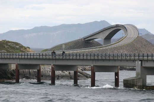
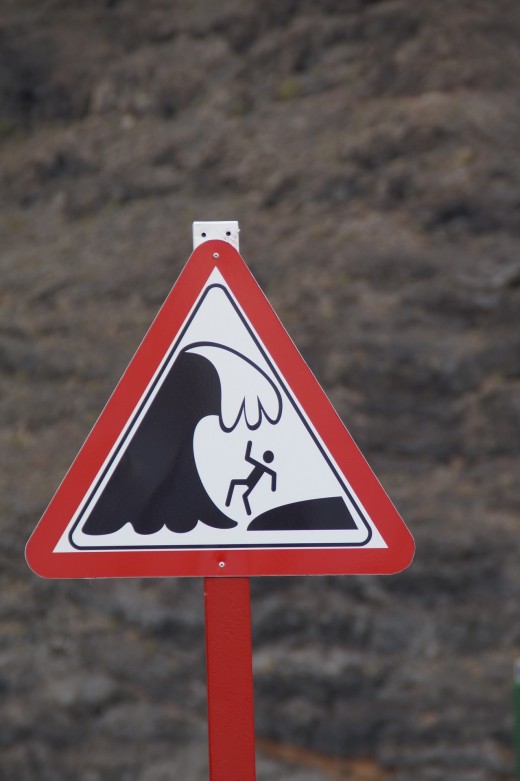
The first part of today's wild journey takes us to Norway, and the amazing Atlantic Road, or as the Norwegians call it, "Atlanterhavsveien or Atlanterhavsvegen." It's a beautiful thoroughfare and fishing destination for locals and tourists. Many people fish directly from the bridges. Cod is one of the most sought-after fish along the Atlantic Road.


Beware of Huge Waves

The beauty of the Atlantic Road also shares a place with danger! Because of its location on the coast, huge waves can wash vehicles and fishermen off the bridges and roadways. Also, harsh winter storms can cause treacherous driving conditions.

The James Dalton Highway

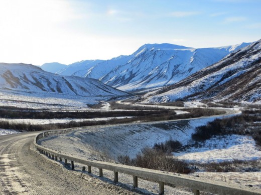
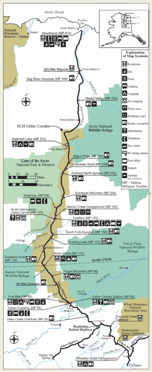
The next destination in our travels is the James Dalton Highway, which stretches for 414 miles through parts of Alaska. It is one of only two roads that cross the Arctic Circle, but the only one in the United States. The other is in Canada. The highway is a very scenic route that takes the tourist through magnificent boreal forests, passed the Arctic Circle, over the Brooks Range Mountains and the Continental Divide to the North Slope tundra at Deadhorse and the Prudhoe Bay oilfields near the Arctic Ocean.

Dangers of The James Dalton Highway

This roadway can be very hazardous at times, and people should make very detailed plans before making this journey. The changing seasons affect road conditions drastically. During the winter season, ice roads and heavy snow can make the highway impossible to travel, and the warming spring and summer weather can cause extreme flooding and wash out parts of the roadway.

There are too many dangers to list them all here, so be sure to check on road and weather conditions before planning your trip. Also, due to the length of the highway, continue to check on them periodically during your trip.

The Waipio Valley Road

Let's now go to a warmer climate and another roadway that sometimes claims tourists as its victims. That roadway is called the Waipio Road, and it is on the big island of Hawaii. It's one of the shortest and most dangerous roads in the world. It's only 3/4 of a mile in length, but its ascent and descent are at an average grade of 25%, with some parts as high as 40%. The height from the Waipio Overlook to the Waipio Valley below is 900 feet. The road is now paved, but still stalls some cars out on the way up and destroys some brakes on the way down.

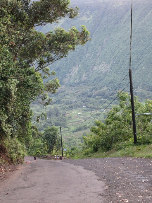
Be Prepared if You Travel The Waipio Valley Road

If you plan to make the journey down and back up on this road, make sure your 4x4 vehicle is in good condition, with good brakes and tires. Also, if you are not an experienced driver on mountain roads, don't attempt this short trip. Also, 2 wheel drive vehicles are prohibited access to the road.

Other conditions that can make this road extremely more dangerous is heavy mist, and snowfall, which can cause avalanches and ice on the roadway. Please, do not attempt to travel this short road in dangerous conditions.

Waipio Valley Road
Waipio Valley Road | Source

The Yungus Road

Finally, we end today's tour in Bolivia, where we meet our most formidable road, Yungas Road, also known as the "Road of Death." This road leads from La Paz to Coroico in the Yungas region of Bolivia. It was named the "World's Most Dangerous Road" by the Inter-American Development Bank in 1995. It's estimated that it takes the lives of between 200 and 300 travelers a year.


Yungas Road
Yungas Road | Source

Yungas Road's Elevation

Yungas Road reaches an elevation of 15,260 ft at La Cumbre Pass and then descends to 3,900 ft at Coroico. It is mostly a single lane road, with no guard rails. There are markers all along the road where travelers have lost their lives. Also, it is not just motorized vehicles that go over the side, over 20 cyclists have died on the ride since 1998.

Yungas Road
Yungas Road | Source

Prepare When You Travel

Now that we have discussed four of the world's most dangerous roads, it opens one's eyes to the dangers these roads can bestow on the traveler. Also, there are many others around the world that have their own nightmares for the unplanned motorist or bicyclist. That's why, if you plan to travel, don't just rely on a map or GPS to guide you to your destination; study information about the route. Some dangers are seasonal, while others are present year-round.


© 2018 Gerry Glenn Jones

working

This website uses cookies

As a user in the EEA, your approval is needed on a few things. To provide a better website experience, hubpages.com uses cookies (and other similar technologies) and may collect, process, and share personal data. Please choose which areas of our service you consent to our doing so.

For more information on managing or withdrawing consents and how we handle data, visit our Privacy Policy at: https://corp.maven.io/privacy-policy

Show Details
Necessary
HubPages Device IDThis is used to identify particular browsers or devices when the access the service, and is used for security reasons.
LoginThis is necessary to sign in to the HubPages Service.
Google RecaptchaThis is used to prevent bots and spam. (Privacy Policy)
AkismetThis is used to detect comment spam. (Privacy Policy)
HubPages Google AnalyticsThis is used to provide data on traffic to our website, all personally identifyable data is anonymized. (Privacy Policy)
HubPages Traffic PixelThis is used to collect data on traffic to articles and other pages on our site. Unless you are signed in to a HubPages account, all personally identifiable information is anonymized.
Amazon Web ServicesThis is a cloud services platform that we used to host our service. (Privacy Policy)
CloudflareThis is a cloud CDN service that we use to efficiently deliver files required for our service to operate such as javascript, cascading style sheets, images, and videos. (Privacy Policy)
Google Hosted LibrariesJavascript software libraries such as jQuery are loaded at endpoints on the googleapis.com or gstatic.com domains, for performance and efficiency reasons. (Privacy Policy)
Features
Google Custom SearchThis is feature allows you to search the site. (Privacy Policy)
Google MapsSome articles have Google Maps embedded in them. (Privacy Policy)
Google ChartsThis is used to display charts and graphs on articles and the author center. (Privacy Policy)
Google AdSense Host APIThis service allows you to sign up for or associate a Google AdSense account with HubPages, so that you can earn money from ads on your articles. No data is shared unless you engage with this feature. (Privacy Policy)
Google YouTubeSome articles have YouTube videos embedded in them. (Privacy Policy)
VimeoSome articles have Vimeo videos embedded in them. (Privacy Policy)
PaypalThis is used for a registered author who enrolls in the HubPages Earnings program and requests to be paid via PayPal. No data is shared with Paypal unless you engage with this feature. (Privacy Policy)
Facebook LoginYou can use this to streamline signing up for, or signing in to your Hubpages account. No data is shared with Facebook unless you engage with this feature. (Privacy Policy)
MavenThis supports the Maven widget and search functionality. (Privacy Policy)
Marketing
Google AdSenseThis is an ad network. (Privacy Policy)
Google DoubleClickGoogle provides ad serving technology and runs an ad network. (Privacy Policy)
Index ExchangeThis is an ad network. (Privacy Policy)
SovrnThis is an ad network. (Privacy Policy)
Facebook AdsThis is an ad network. (Privacy Policy)
Amazon Unified Ad MarketplaceThis is an ad network. (Privacy Policy)
AppNexusThis is an ad network. (Privacy Policy)
OpenxThis is an ad network. (Privacy Policy)
Rubicon ProjectThis is an ad network. (Privacy Policy)
TripleLiftThis is an ad network. (Privacy Policy)
Say MediaWe partner with Say Media to deliver ad campaigns on our sites. (Privacy Policy)
Remarketing PixelsWe may use remarketing pixels from advertising networks such as Google AdWords, Bing Ads, and Facebook in order to advertise the HubPages Service to people that have visited our sites.
Conversion Tracking PixelsWe may use conversion tracking pixels from advertising networks such as Google AdWords, Bing Ads, and Facebook in order to identify when an advertisement has successfully resulted in the desired action, such as signing up for the HubPages Service or publishing an article on the HubPages Service.
Statistics
Author Google AnalyticsThis is used to provide traffic data and reports to the authors of articles on the HubPages Service. (Privacy Policy)
ComscoreComScore is a media measurement and analytics company providing marketing data and analytics to enterprises, media and advertising agencies, and publishers. Non-consent will result in ComScore only processing obfuscated personal data. (Privacy Policy)
Amazon Tracking PixelSome articles display amazon products as part of the Amazon Affiliate program, this pixel provides traffic statistics for those products (Privacy Policy)
ClickscoThis is a data management platform studying reader behavior (Privacy Policy)