Copper Canyon Passenger Train in Mexico - What a Ride!


Mexico's Copper Canyon (Barrancas del Cobre) Train Ride is a Must!
Introduction to the Copper Canyon and the El Chepe, the Copper Canyon Train
The Copper Canyon, or Barrancas del Cobre in Spanish, is one of the most remote areas of Mexico. The Copper Canyon has the City of Chihuahua on its eastern border, El Fuente on its western edge. Guachochi touches the southern border. Basaseachi, home of a 800+ foot high waterfall, touches the northern canyons.
Additionally, the Mexicans name for the area Barrancos del Cobre means the ravines of copper . The names themselves are a misnomer. Copper Canyon is not a canyon nor a ravine, but 6 distinct canyons. Uniquely formed over 1,000's of years, the 6 rivers, combined with the rains, continually reshape the canyons. Put together, the 6 rivers would have a length of over 37,000 miles!
Comparatively, depths within the 6 canyons are deeper, the area larger, than the Grand Canyon. Mountain cliff's are copper-colored, hence the name Copper Canyon. The canyon complex is in the state of Chihuahua, Mexico.
Equally important, the climate within the Copper Canyon complex helps shape the canyons. On the floors, the climate is sub-tropical. Correspondingly, snow may fall in the mountains, at higher elevations. Together with the rivers, rain and snow, the climate helps transform the appearance of the canyons, year after year.
Tarahumara, the indigenous people of the area, are farmers. They farm the lower levels of the canyons in the winter and the high mountain areas in the summer. The Tarahumara are known as the "runners of the canyon". They trek up and down the mountains, sometimes running for long distances, to reach their farms.
The reason the El Chepe Train route was built was to allow one consistent venue for transportation through the Copper Canyon. The El Chepe allows the loggers and miners a way of getting the resources out from the Copper Canyon.
The best time to take the El Chepe is in the rainy season. The area is full of vegetation in their most colorful stage. The waterfalls are coming off cliffs throughout the train ride. The rivers are raging throughout the canyon floors.
If you love waterfalls, I've included a video of the Basaseachi Waterfall. The falls are the second highest in Mexico.
The Basaseachi Waterfalls, Over 800 Ft. High!
The Railway Line and the Engine's Name
Additionally, the railway line's name is Ferrocarril Chihuahua el Pacifico. (Chihuahua Pacific railway) El Chepe (God will increase) is the name of the engine that pulls the passenger cars. Moreover, the train consists of ten cars - 2 or 3 (depending on demand) 1st class cars, 6 or 7 2nd class cars and a dining car.
Furthermore, the train leaves the City of Chihuahua and heads west to the town of Los Mochis. In Los Mochis, the train does a 180 degree turn and heads back to the City of Chihuahua. Paying $100 for the round trip, was one of the best deals I've run across!
Between the City of Chihuahua and the town of Creel, the canyon slowly starts to appear. West of Creel is where the canyon gets deep, so I caught the train in Creel. The terrain is pretty mundane after El Fuente, so I stopped and spent the night. I caught the train back to Creel the next morning.


The Ride is Slow
The train can never pick up any speed. It starts off by following the rim of the Copper Canyon in the high elevations. There is never any great length of straight track. Picking up people in the smaller towns west of Creel, El Chepe moves along the tracks. About 2 hours into the ride, it starts the slow decent to the bottom of the canyon. The best side of the train to sit is on your left if heading west, and on your right if heading east.

The Tracks are Straight for Bridges
The tracks straighten up when approaching a bridge, but even then the train doesn't speed up. The train goes over bridges and through the tunnels at slow speeds.
There are 36 bridges that the train has to cross going to El Fuente, which is where I'll get off. The sights between the City of Chihuahua/Creel and the sights between El Fuente/Los Mochis are blasé. My suggestion, if you take the train, go from Creel to El Fuente, or vice versa.
")
Tracks are Maintained 24/7, 365 Days a Year
The El Chepe runs every day, either heading east or heading west. It's one of the best tourist attractions in the State of Chihuahua. Hence, the tracks are maintained 24/7, 365 days a year. It's the best maintained train track in Latin America. Ferrocarril Chihuahua el Pacific does not want to miss the tourist dollars!

The Best Time for the Train Ride is the Rainy Season
Ideally, you want to see the waterfalls and the lushness of the canyons. Of course, the lushness happens during the rainy season, not to mention waterfalls appearing everywhere. Most importantly, you want to see all the waterfalls along your train ride
Rainy season weather patterns work in favor of the train traveler. In the morning it's usually sunny. As the afternoon unfolds, the clouds begin to form. The rains usually don't come until the latter part of the afternoon. For myself, when the rains came about 4PM, I was happy with the pictures I took, and enjoyed the train ride. The timing couldn't have been better!

Train Derailments Are Unusual
The train ride is safe. The picture below shows a freight car derailed - might have been loaded wrong. Although, with the train's rocking back and forth, the river roaring through the canyon within spitting distance, the waterfalls going underneath the tracks, it does give you a minor case of the willies!
Gently turning tracks follow the river, slowly making a u-turn over the river, placing you on the other side. The rocking stops, the train heads higher and higher, and calmness returns.


People Live Throughout the Canyons
People live all around the canyons. They log wood, tend farms and try to find more gold and silver in them thar' hills. This is the Mexican Alaska - the most inaccessible part of Mexico.
Of course, the logs and minerals have to get out of the canyons. Thus, the rail way was built. The construction started in the early 1900's and was completed - from Chihuahua to Los Mochis - in 1961.


Tunnels, Tunnels and More Tunnels
The canyon wall's rise into the clouds. For about 4 hours your at the bottom of the canyons. It's really remote and rough terrain. It gives you an idea why it took almost 60 years to build.
I imagine the engineers thought, "Up and over or through the mountains?"
In the end, they did both. In many parts it wasn't workable to go up and over. In fact, it wasn't feasible 86 times! That's the number of tunnels the train passes through! 86 tunnels are a lot of dynamite and rock!


The River's Dammed Outside of El Fuente, Mexico
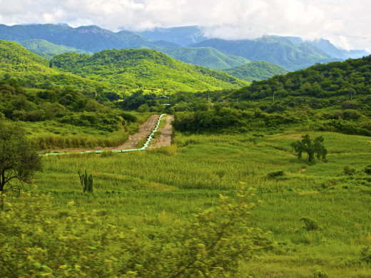
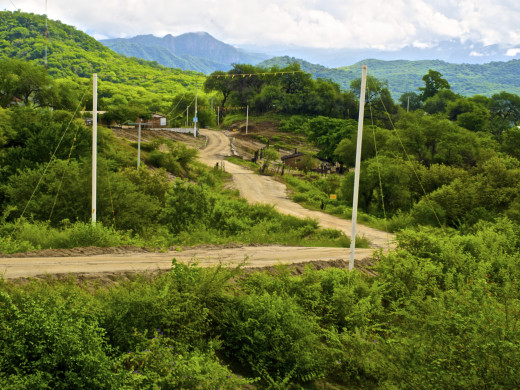
About 30 miles outside of El Fuente, they've built a hydroelectric plant, El Cajon. Mexico needs low cost electricity and they felt this was the best way to achieve the goal. They had to move a town to a new location because of the dam project and the lake that formed. The electrical lines you'll see further down in the photos are coming from El Cajon.
What resulted was some of the best bass fishing in North America. Bass fishing excursions can be taken out of El Fuente, to El Cajon. Even with the dam, it's still quite a remote spot, with great scenery and fishing. The combination of a Copper Canyon train ride and a fishing expedition would be quite the adventure!


Modernization is Coming Quickly
Mexico wants to get the minerals and lumber out the canyon area. Therefore, roads, power lines and pipes for water distribution are coming into the Copper Canyon. Destroying pristine mountains, rugged landscape and upsetting the ecosystems is collateral damage.
The indigenous people lose their way of life. Habitats change, animals disappear. The landscape changes because the trees are cut, leading to quick erosion of the canyon in general.
The lake fills up with silt, slowing the water flow, slowing the electrical production. But, it's hoped that there will be ways to maintain it.
As more of the Copper Canyon area opens up for farming, logging, mining and tourism, the ruggedness, the pristine beauty and the charm diminishes. All in the name of progress.

Copper Canyon Train Ride Highlights
1) The Copper Canyon Railway took more than 60 years to complete
2) The trip covers 405 miles
3) The rail line crosses 39 major bridges
4) The rail way goes through 86 tunnels
5) The El Chepe makes 15 stops scheduled stops between Chihuahua and Los Mochis. There are 9 train stations.
6) The El Chepe will stop for anyone standing along the rail road tracks.
7) The train ride is 14 hours long, if there are no delays due to landslides.
8) The highest elevation that the train gets too is 7,900 ft. above sea level.
9) The El Chepe goes through 5 different climate zones
10) The deepest part of the train ride is in Urique Canyon
In the map below, you'll see the layout of the Copper Canyon. Upper right shows Chihuahua, lower left shows Los Mochis. Lower middle is Guachochi and in the north is Área Natural Protegida Tutuaca, just outside the small city of Basaseachi.
The map gives a great view of the total area. Just hours from El Paso, a weekend getaway to the Copper Canyon is easy peasy! Just be sure there's limited violence!
Remember, travel safely and play nice!
The Copper Canyon - Chihuahua to El Fuente, Guachochi to Area Natural Protegida Tutuaca

My rating of the Copper Canyon Train Ride
The Copper Canyon Guide


