ArtsAutosBooksBusinessEducationEntertainmentFamilyFashionFoodGamesGenderHealthHolidaysHomeHubPagesPersonal FinancePetsPoliticsReligionSportsTechnologyTravel

Travel North - 66: Dales Maiden Overlooks the River Swale - Walk via an Iron Age Hill Fort in Lead Mining Country

Updated on April 11, 2020

Upriver from Richmond by Arkle Beck, away from the River Swale lies Reeth...

Reeth Green stretches either side of the Richmond to Muker road through Swaledale;, rows of businesses and hotels line the upper end of the road near where the Arkengarthdale road climbs away
Reeth Green stretches either side of the Richmond to Muker road through Swaledale;, rows of businesses and hotels line the upper end of the road near where the Arkengarthdale road climbs away | Source
The River Swale, near where Arkle Beck joins after passing by Reeth
No view of Swaledale - or any partt of the Dales for that matter - is complete without a stone barn set amid dry stone wall enclosures
No view of Swaledale - or any partt of the Dales for that matter - is complete without a stone barn set amid dry stone wall enclosures | Source

Set where the road west to Muker joins the Arkengarthdale road,

around a large green town was the beating heart of local lead mining until when cheaper imports killed it off in the 1920s. High moors surround the district where the River Swale meanders in large horseshoe bends... most of the time. Unseasonable floods hit upper Swaledale in the disastrous summer of 2019, destroying the old stone bridge at nearby Grinton to the south, engulfing that side of the Bridge Inn.

We're here to forget all that and concentrate on a pleasant although at times demanding walk. Pass between impressive 18th and 19th Century stone-built houses and businesses south to the river, along by the National Park centre to the workmanlike Anvil Square. From here take the path marked, "To the river" and take a right onto a lane that heads west. Not far along here another left turn sees you following the path as it wends right and toward the river. A suspension bridge here was torn away from its moorings in 2000, rebuilt as it was in 1920.

Across the River Swale you could turn immediately right and along the river bank, although the public right of way is a few yards further, up the hill after you've crossed the bridge. ..


Across the Swale and uphill...

The suspension bridge across the Swale, washed away asnd replaced in the original style - seen from the riverside path
The suspension bridge across the Swale, washed away asnd replaced in the original style - seen from the riverside path | Source
Closer - sidelong view of the suspension bridge
Closer - sidelong view of the suspension bridge | Source
Overlooking the remains of the Iron Age hill fort named Maiden Castle, with the site of Grinton smelt mill
Overlooking the remains of the Iron Age hill fort named Maiden Castle, with the site of Grinton smelt mill | Source
The panorama back over Swaledale, north to Reeth
The panorama back over Swaledale, north to Reeth | Source

Take a right turn back to the river and follow the track half a mile to a farm...

An 'arch' shaped set of stepping stones juts out into the river here, although I wouldn't suggest you use them - they're not on your way for a start - but walk between the farm buildings and ascend to a road.

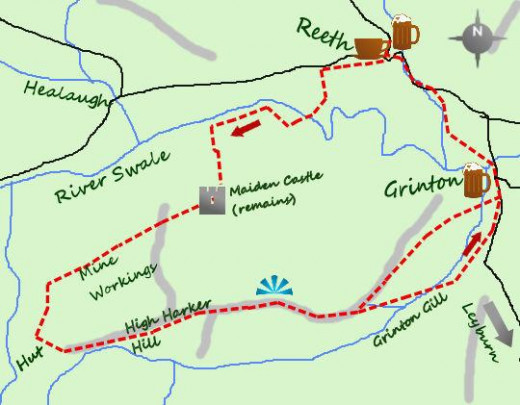
Turn left for a a little over a hundred yards along the road before following a signposted footpath. This footpath climbs the hill away from the road to a large clump of bushes. This is the site of Maiden Castle - there is another not far away to the north on Stainmoor - what was an Iron Age hill fort, and what you can see is reasonably preserved.

Take a path from the south-west corner of the site that leads roughly south-west for a half mile. You'll see the spoilheaps left after Harker Lead Mine was abandoned, one of the earlier workings that brought the Industrial Revolution to Swaledale from the 1700s. You'll see reminders frequently around the area that gave this part of the dale its own character that it shares with nearby dales.

There are two tracks that climb the hillside, and meet either side of a shooting hut, a hazardous place to hang around from the 'Glorious Twelfth' of August (grouse season). You are now at Browning Gill, a spring where you take a left turn to a wide track used by shooting party off-road vehicles, and go east across the high, flat Harker Hill. From here you can look out over Reeth and up to Arkengarthdale, an open, majestic panorama. You can follow the vehicle track for two miles, although you don't have to go as far as that, as a couple of paths cut the corner. Your point of reference is Grinton Tower and Youth Hostel. One path is good for walking and misses out some road walking at a later stage. You come to north of the lodge, a few minutes walk into Grinton villager Take a look at the impressive stone-built St Andrew's Church. A path to you left avoids later trekking along the road, and reaches the north side of the lodge, a short walk into Grinton village. A path to your left lets you bypass the road, crosses pasture land by the River Arkle. Where the path comes to the road you only have a few minutes' stroll back into Reeth with its cafes, grand-looking hotels and public houses. My own favourite at any time of year is The Bull', close to the crossroads, where to the north the Arkengarthdale road climbs steeply away between the houses and the Muker road by comparison eases along away westward from the green.

Downhill again to Grinton, another bygone centre of Swaledale's lead mining past

St Andrew's church, Grinton, an impressive piece of Dales architercture
St Andrew's church, Grinton, an impressive piece of Dales architercture | Source
Grinton village sits astride the road that climbs to the moor and Leyburn in Wensleydale
Bridge Inn, Grinton on a glorious sunny summer's day - the centre span of the bridge close by was swept away by the raging Swale in 2019's 'summer of discontent'
Bridge Inn, Grinton on a glorious sunny summer's day - the centre span of the bridge close by was swept away by the raging Swale in 2019's 'summer of discontent' | Source

You will have walked around seven miles, and climbed to around 1,050 feet (320 m)...

starting at Ordnance Survey Explorer map reference SE038993 [Explorer map no. 30]. This walk is not too hard, although the many footpaths could cause confusion near the river, and a climb to the moor from the suspension bridge can be strenuous if you're not used to hill climbing. Broadly speaking you have Takean enjoyable, easy-ish walk with a brisk descent into Grinton.

Take an Ordnance Survey map (recommended, and when you learn to read them they're indispensable) that will be better than the sketch map here that is only of use as a general guide. If there's a mist - and near rivers or standing water at some times of the year that's not unheard of - you'll find a good compass useful.

Wear good, sound walking boots, not trainers that let in wet, sometimes near a river the going could be squelchy or waterlogged, muddy and slippery. By the same token jeans are not ideal as they too let in and retain the damp. This may not be a long hike, but comfort is the key to enjoying a walk in the countryside. Take weatherproofs, and good woollen socks in spring or autumn especially.

Keep an eye open for heavy weather. If it looks threatening but could blow over before you set out bide your time. Do some shopping for snacks - chocolate or Kendal Mint Cake is good to keep up energy levels. Have a look around the Reeth Mining Museum, it'll give you an idea of what the lead miners had to put up with., and it'll make for an enjoyable interlude during your day.

A word to the wise: parking in Reeth is limited. On the green there's a cobbled area where a regular small market takes place outside the 'Black Bull Hotel'. Check online for market days for optimum parking Locals will not take to you if you block access paths or driveways.

Most of all, enjoy your walk!


And back to Reeth across the dale...

The view north-west over Reeth
The view north-west over Reeth | Source
The Black Bull Hotel faces directly onto the green...
The Black Bull Hotel faces directly onto the green... | Source
... whereas The Black Bull sits beside the road junction where the road to Muker passes to the left in this picture and the steep road up Arkengarthdale on the right - confusin' innit!
... whereas The Black Bull sits beside the road junction where the road to Muker passes to the left in this picture and the steep road up Arkengarthdale on the right - confusin' innit! | Source
Source

There is a regular Dalesbus service if you choose to arrive by road other than by driving.

Here are a couple of general maps of the Dales area you'll be in, to acquaint you with the region. York is around two hours' drive away, Richmond is connected to Darlington by Arriva bus services and Darlington is on the East Coast Main line for fast services from Newcastle-upon-Tyne or York - or further afield. Book a hotel room or bed & breakfast unless you have plans to rent a property nearby for a week or whatever. That's probably the best course to take and you have a choice of walks from these pages.

Where is Reeth and how do I get there?

The central Dales - Yorkshire - an outline map that shows how Swaledale and its 'neighbours' fit together
The central Dales - Yorkshire - an outline map that shows how Swaledale and its 'neighbours' fit together | Source
An overall map of the Dales region - places you've read about in my other 'Travel North' pages are here

© 2020 Alan R Lancaster

working

This website uses cookies

As a user in the EEA, your approval is needed on a few things. To provide a better website experience, hubpages.com uses cookies (and other similar technologies) and may collect, process, and share personal data. Please choose which areas of our service you consent to our doing so.

For more information on managing or withdrawing consents and how we handle data, visit our Privacy Policy at: https://corp.maven.io/privacy-policy

Show Details
Necessary
HubPages Device IDThis is used to identify particular browsers or devices when the access the service, and is used for security reasons.
LoginThis is necessary to sign in to the HubPages Service.
Google RecaptchaThis is used to prevent bots and spam. (Privacy Policy)
AkismetThis is used to detect comment spam. (Privacy Policy)
HubPages Google AnalyticsThis is used to provide data on traffic to our website, all personally identifyable data is anonymized. (Privacy Policy)
HubPages Traffic PixelThis is used to collect data on traffic to articles and other pages on our site. Unless you are signed in to a HubPages account, all personally identifiable information is anonymized.
Amazon Web ServicesThis is a cloud services platform that we used to host our service. (Privacy Policy)
CloudflareThis is a cloud CDN service that we use to efficiently deliver files required for our service to operate such as javascript, cascading style sheets, images, and videos. (Privacy Policy)
Google Hosted LibrariesJavascript software libraries such as jQuery are loaded at endpoints on the googleapis.com or gstatic.com domains, for performance and efficiency reasons. (Privacy Policy)
Features
Google Custom SearchThis is feature allows you to search the site. (Privacy Policy)
Google MapsSome articles have Google Maps embedded in them. (Privacy Policy)
Google ChartsThis is used to display charts and graphs on articles and the author center. (Privacy Policy)
Google AdSense Host APIThis service allows you to sign up for or associate a Google AdSense account with HubPages, so that you can earn money from ads on your articles. No data is shared unless you engage with this feature. (Privacy Policy)
Google YouTubeSome articles have YouTube videos embedded in them. (Privacy Policy)
VimeoSome articles have Vimeo videos embedded in them. (Privacy Policy)
PaypalThis is used for a registered author who enrolls in the HubPages Earnings program and requests to be paid via PayPal. No data is shared with Paypal unless you engage with this feature. (Privacy Policy)
Facebook LoginYou can use this to streamline signing up for, or signing in to your Hubpages account. No data is shared with Facebook unless you engage with this feature. (Privacy Policy)
MavenThis supports the Maven widget and search functionality. (Privacy Policy)
Marketing
Google AdSenseThis is an ad network. (Privacy Policy)
Google DoubleClickGoogle provides ad serving technology and runs an ad network. (Privacy Policy)
Index ExchangeThis is an ad network. (Privacy Policy)
SovrnThis is an ad network. (Privacy Policy)
Facebook AdsThis is an ad network. (Privacy Policy)
Amazon Unified Ad MarketplaceThis is an ad network. (Privacy Policy)
AppNexusThis is an ad network. (Privacy Policy)
OpenxThis is an ad network. (Privacy Policy)
Rubicon ProjectThis is an ad network. (Privacy Policy)
TripleLiftThis is an ad network. (Privacy Policy)
Say MediaWe partner with Say Media to deliver ad campaigns on our sites. (Privacy Policy)
Remarketing PixelsWe may use remarketing pixels from advertising networks such as Google AdWords, Bing Ads, and Facebook in order to advertise the HubPages Service to people that have visited our sites.
Conversion Tracking PixelsWe may use conversion tracking pixels from advertising networks such as Google AdWords, Bing Ads, and Facebook in order to identify when an advertisement has successfully resulted in the desired action, such as signing up for the HubPages Service or publishing an article on the HubPages Service.
Statistics
Author Google AnalyticsThis is used to provide traffic data and reports to the authors of articles on the HubPages Service. (Privacy Policy)
ComscoreComScore is a media measurement and analytics company providing marketing data and analytics to enterprises, media and advertising agencies, and publishers. Non-consent will result in ComScore only processing obfuscated personal data. (Privacy Policy)
Amazon Tracking PixelSome articles display amazon products as part of the Amazon Affiliate program, this pixel provides traffic statistics for those products (Privacy Policy)
ClickscoThis is a data management platform studying reader behavior (Privacy Policy)