Burial Mounds on the Minnesota and Ontario border along Rainy River

Ancient Burial Mounds that are historic and cultural treasures
Burial mounds can be found throughout North America, but there is a certain concentration along the Rainy River, which serves as the border between Minnesota, USA and Ontario, Canada. The Smith site on the US side near the confluence of the Big Fork and Rainy Rivers has five burial mounds, one of which is the largest in Minnesota. This lens will tell a bit about these mounds and the effort to protect and preserve them.
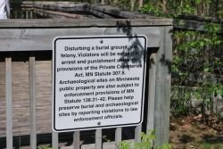
Other than signage warning to not dusturb these sacred sites, little helps to preserve these sites in Minnesota.

Take a quick tour of the mounds
This tour was conducted May 18, 2012
A group representing the Native communities and other interested parties toured the mounds on both sides of the Rainy River as part of an ongoing effort to understand the Laurel and Blackduck culture mounds. An Interpretive center at Grand Mound was closed a decade ago for budgetary reasons, (photo-right) but there is an operating interpretive center on the Canadian side called Kay-Nah-Chi-Wah-Nung which tells about the mounds and ancient native culture at that site near the Long Sault Rapids.
This lens wil focus on the US side, as there is ample information available on the Manitou Mounds on the internet, see the link below.
Here's the link!
- Kay-Nah-Chi-Wah-Nung
Also known as the Manitou Mounds, the Kay-Nah-Chi-Wah-Nung website has extensive information and photos.
The Grand Mound


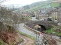
The tour starts at International Falls
Following an evening information session and dinner Thursday, May 17th, the group boarded a bus Friday morning for a tour that would take them through the entire Rainy River valley. On the way to the first stop near Pelland Junction and the confluence of the Little Fork and Rainy Rivers, the group shared information and discussion on the history of the mounds.
Westward Ho!


First Stop
The bus stopped at the Little Fork River Bridge just west of Pelland Junction, there, everyone disembarked for a short hike to the river flats on the east bank of the Littlefork and South Bank of the Rainy. There are two mounds here, known as the McKinstry Mounds. The first is nearly circular and eighty-three feet in diameter and has been excavated. The second mound is closer to the waters edge on a lower terrace that occasionally floods. This mound was lowered by cultivation and is now four feet high, sixty feet long and fifty feet wide.
McKinstry Mound I


Showing respect and honor
In the photo above, representatives of the native culture show their respect and offer tobacco at the site of McKinstry Mound I, in the photo to the right, the group looks northwest to the mound found lower on the riverbank terrace and nearer the Rainy River. The mounds have been excavated and extensive artifacts were found. Among the significant finds are a few objects of copper, 29 socketed antlerpoints and objects of chipped stone like arrowpoints and scrapers. The excavations provided a great deal of information on the anciet Laurel culture that built the mounds, but the information comes at a price. After all, these are burial grounds of a native culture and many aboriginal groups are troubled by disturbances at these sites.

Major Disturbance
All Terrain Vehicle tracks are clearly visible cutting up and over the top of the mound. The group concluded that education and some form of regular inspection at the site could help prevent this type of damage. People riding ATV trails along the riverbanks are probably not even aware that these are burial mounds.

Impromptu preservation discussion
After seeing the damage from an ATV trail over the first mound, the group began a discussion of means to better preserve the sites. One point made was that fencing off the site, given the remote location, might only encourage people to breech the fence to see why it's there. Placing signage might encourage amateurs to dig in the mounds.
Next stop, the shuttered Grand Mound Center.


Relatively easy walking
Although the visitor center was closed in 2003 for budgetary reasons, and permanently closed in 2007 by the Minnesota Historical Society, the walkways, paths and signage have been maintained. This was a special tour, allowing the visitors to pass through the now empty and locked center to gain access to the walkways. When the center was operating, visitors could grap a pamphlet to accompany them on the walk to the mounds, with points of interest marked with sign posts.
These Mounds are Cemeteries
Please treat them with respect. If you are unsure of where you are going, or if you might be trespassing, don't go!


Building Materials
As the group walked the trail, they could see the signposts from the old self guided tour. In the photo above, the north facing slope favors the growth of paper birch, maple, green ash and black ash, important building materials for canoes, shelter, snowshoes and more. Other stops point out different resources, such as bloodroot, which was commonly used as a dye and a medicine. Many artifacts found at the Smith site were excavated at the sites of small camps that formed when people gathered to harvest needed materials that continue to grow naturally in this river bank area.

Lowlands trail
It is a good thing that the trails have been maintained, or there would be considerable underbrush. This is a lowland river bank with plenty of standing water, which means mosquitoes and other insects. This part of the pathway is heading north toward the Rainy River and the five ancient mounds to be found here. This site is named the Smith site because the long-time owner of the area was pioneer Frank Smith.
Hiking/Ski Trail Map


The Grand Mound Site!
It may be a little tough to read, but this is the map from the self-guided tour used when the center was in operation. The pathway from the visitor center travels north to the Grand Mound, then you are instructed to head east along the riverbank to see mounds #2 and #5 before continuing west to encounter #3 and #4. The Grand Mound is Mound #1. The photo to the right shows the mound.
The mound has never been excavated scientifically, however, there have been extensive disturbances. Steamboat excursions on the Rainy River often stopped at the site so passengers could dig around a bit. Also, some local residents made an effort to tunnel through the mound in 1884 leaving scars on the north and south sides of the mound.


Waters of the Dancing Sky Scenic Byway
The scenic byway begins at Sha Sha point on Rainy Lake. The State of Minnesota sign indicates that Highway 11 ends there, but we all know that this is where it starts! The byway will go past both the McKinstry and Smith sites, and many other interesting stops. Basshenge is an interesting, if quirky roadside artwork that consists of sheet steel bass violins mounted on concrete pillars roughly in the shape of Stonehenge. There are hiking trails and scenic views at Manitou Rapids near Indus and the Long Sault rapids near Franz Jevne State Park and Nelson Park in Birchdale. There are waysides by the Rainy River and a wonderful rapids where the Rapid River flows into the Rainy at Clementsen. There are things to see and do in Baudette, Warroad, Roseau and the Hallock area as the byway continues west. You would do best to check with their local tourism offices for the most up-to-date information on thing to see and do there.
There will be a link to the byway website below.
Learn More about the Rainy Lake and Rainy River region
- Lodging? Restaurants? Guide Services?
All the information you might need to plan a trip to the Rainy Lake and Rainy River region can be found here. - Waters of the Dancing Sky Scenic Byway
A little about everything along this scenic drive from Voyageurs National Park to the North Dakota border.
I never knew!
Let me know if this is news to you, take the poll!
Did you learn something new?
Related

Day Trip to Little American Falls on the Big Fork River

Was Serpent Mound Built by Ancient Aliens?

A Hike at Gungywamp in Groton, Connecticut

Surnames G-Q - Family History; English Genealogy, Gravestone Photographs and Information

Palawan Tour - The Underground River in Puerto Princesa - El Nido - Coron, Philippines