Capitol Reef National Park


Untouched Desert at the Waterpocket Fold and Capitol Reef National Park
The area of southern Utah desert known as Capitol Reef National Park is one of the newer discoveries in the United States, with paved roads leading to the park constructed only in the 1960's. The giant ripple of the Earth's crust known as Waterpocket Fold in Capitol Reef is full of Puebloan history in the form of petroglyphs, while tourists flock to the park for photography, hiking, and camping on these scenic grounds. Read on to find suggestions on where to stay, find beautiful photos of Capitol Reef National Park, and things to do within the park.
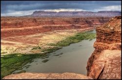
Photo top left: Capitol Reef National Park photo by Wolfgang Staudt on flickr, licensed under Creative Commons 2.0.Goosenecks Overlook, Capitol Reef National Park.
Photo by mandj98 on flickr, filed under Creative Commons 2.0.
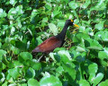
Some of the best sites within Capitol Reef are not on the paved roads, but beyond them in the brush, on the trails, and on top of the amazing "reef." Get up close and personal with the wildlife and step away from the parking lot!
The park has a trail leading to ancient petroglyphs called Petroglyph Pullout. This trail is 1 1/2 miles from the visitor's center and affords an intriguing view of the centuries old artwork on rock.
Mountain biking is one of the best ways to see Capitol Reef. With several trails from easy to strenuous, you can count on seeing a good portion of the park via mountain bike.
Capitol Reef is becoming increasingly popular for rock climbers. The area has unique formations and a variety of challenges. Permits are not required, but you need a backcountry permit to camp overnight.
As you can see by the photos at the link above, the park has incredible photography opportunities all over.
Capitol Reef National Park Jupiter by mandj98 on flickr, licensed under Creative Commons 2.0.
Capitol Reef National Park Photo available at AllPosters.
- The park was established as a National Park in 1971.
- Capitol Reef National Park encapsulates the Waterpocket Fold, a 65 million year old piece of the Earth's crust that is often described as a "wrinkle."
- The word "reef" comes from a local term used to describe large, impassable rocks.
- The word "capitol" to describe the park was used to describe the large white domes that line the top of the folds.
- August 2, 1937, the park was declared a National Monument by President Roosevelt.
- The park was once the edge of a shallow sea millions of years ago.
- - Torrey, Utah, is the town closest to the park (8 miles).
Where to Stay Near Capitol Reef
Hotels and accomodations near the park
Torrey, Utah, is the town closest to the park. It's around 8 miles from the park, while I-70 runs through parts of the protected area. There are plenty of accomodations to choose from in the town of Torrey. Here are some hotels and lodging in town:
Sandstone Inn & Restaurant, Torrey,UT
Formerly Wonderland Inn, this #3 hotel in Torrey on Trip Advisor has clean, comfortable rooms, a hot tub, and the perfect easy accessibility to the park gate.
The beautiful grounds of Austin's Chuckwagon lodge are a welcome retreat from the desert heat, with clean grounds and a pool nestled amongst trees and shade. Rated #1 on Trip Advisor!
Best Western Capitol Reef Resort, Torrey,UT
Just a few miles from the gates of the park, this #2 rated hotel on Trip Advisor is an excellent deal, with efficient and friendly staff and comfortable rooms.
Days Inn Capitol Reef, Torrey,UT
At the end of Scenic Route 12 with free wifi! This hotel is a great bargain and very affordable.
Hickmans Natural Bridge in Capitol Reef.
Photo by mandj98 on flickr, licensed under Creative Commons 2.0.
No trip to the southwest is complete without a good guide. Reading up ahead of time will give you a greater appreciation for what the area has to offer, and you'll know what to look for. You'll also be able to weave other local oddities and attractions into your trip.


Capitol Reef runs about 75 miles long, from Thousand Lake Mountain to Lake Powell.
Have you been to Capitol Reef National Park?
Photographing the Southwest - A journey to America's southwestern National Parks, monuments and towns
Go beyond the scope of "the Grand Circle" and find everything that the Colorado Plateau and southern Utah have to sightsee in this tremendous guide by Laurent Martres. It also covers the remote northeastern area of Utah, Dinosaur National Monument, along with Native American dwellings and all of the major parks as well.

Utah Road Trip! - See the scenic roads of Utah!
Utah is a state like no other. With five major National Parks, and a dozen or more other monuments, state parks and protected areas in just the southern area alone, the state is a vacation on its own. This guide will show you some of the best roads to travel, where those hidden beauties are, and how to plan out your Utah road trip.

A Slideshow of Capitol Reef Photos - Click to view!
More Lenses in the Grand Circle: - Visit America's southwest!
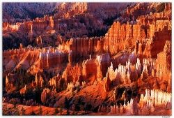
Bryce Canyon National ParkBryce Canyon is located in the southwestern portion of Utah, and is home to the famous red and white hoodoos spire formations, with remarkable hiking trails and scenic opportunities.
Capitol Reef National ParkA 70 mile wrinkle in the earth's crust resulted in the massive Capitol Reef area and National Park. Giant sandstone domes line the tops of this beautiful Utah plateau.
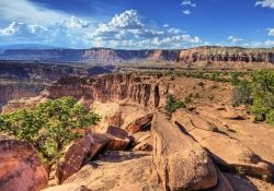
Canyonlands National ParkWind and water carved stone resulted in the area near Arches known as Canyonlands. The area boasts impressive, wide canyons, unique desert wildlife, and unmatched hiking.

Zion National ParkThe majestic Zion region has been eroded over time by the Virgin River, which slims down to the challenging hiking area of the Narrows.
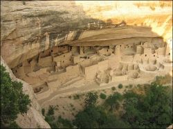
Mesa Verde National ParkRemnants of a long lost culture can be found in the Colorado ruins of Mesa Verde National Park. Visit to gaze upon the incredible Puebloan Cliff Palace and ancient petroglyphs.
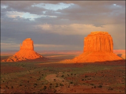
Monument ValleyDeep in the four corners region of the southwest is the often filmed Monument Valley reservation area. Now under the rule of the Navajo tribe, the area is open for touring, hiking and photography.
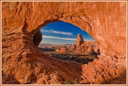
Arches National ParkSee the most natural sandstone arches anywhere in the world in Arches National Park of Moab, Utah. Erosion has left thousands of these unique stone structures standing in the park.
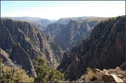
Black Canyon of the GunnisonDeep, black canyons leave a lasting impression in Colorado's Black Canyon of the Gunnison, with an impressive 2700 foot drop over into the Gunnison River.
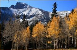
Great Basin National ParkGreat Basin National Park contains the beautiful underground Lehman's Cave, and the mammoth peak of Mount Wheeler. Hike the area from its 13,000 feet peak, to beneath the earth's surface.
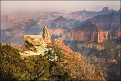
The Grand CanyonThe Grand Canyon is one of the wonders of the world, with an unforgettable hiking, photography, and road trip experience.
Photo of Capitol Reef National Park juniper below by jotor on flickr, licensed under Creative Commons 2.0.
Thanks for Visiting!
A lone Juniper in Capitol Reef National Park