Flagstaff - Hub for Scenic Beauty

Just a Hop, Skip, and a Jump to Everywhere Else
Hop, skip, or jump to many different scenic wonders, from Flagstaff, Arizona. You might say it is a sleepy little college town, but it's close to everything you might want to see if you like scenic locations.
The college population probably causes the total population to grow to three or four times what it would be otherwise. Because of so many students, there are many wonderful places to eat.
Nearly all the motels are across the street from the railroad tracks. If you don't mind sleeping to the sound of grinding and whistling trains, you can stay just about anywhere you want. If you live in the boonies where it is deathly quiet at night, you won't want to sleep there, so I will tell you where you can sleep and be relatively undisturbed.
I will also tell you about the good eatin' places.
Among the wonderful places you can visit:
Grand Canyon - about 80 miles
Sunset Crater - about 20 miles
Lockett Meadow - about 21 miles
San Francisco Peaks (good skiing) - about 14 miles
Meteor Crater - about 38 miles
Painted Desert - right next to the Petrified Forest
Petrified Forest - about 109 miles
Wupatki Ruins - about 44 miles
Oak Creek Canyon - about 30 miles (actually runs a distance starting close to Flag)
Sedona - about 32 milesTuzigoot Ruins - about 70 miles
Montezuma Castle - nearby
Montezuma's Well - nearby
Jerome - about 78 miles (old ghost town, now artist community)
Still giving distances from Flagstaff, but if you are willing to range a little bit further, perhaps moving your headquarters a bit north to Page, for example, or to Moab, you can see:Vermilion Cliffs - 177 miles (but you travel alongside them for quite a distance)
Glen Canyon - 129 miles (91 miles from Page)Coyote Buttes - 173 miles (the area where you will find The Wave; permit required), or about 61 miles from Page
Lake Powell - 130 miles or so (right next to Page)
Antelope Canyon - near Lake Powell and Page
Horseshoe Bend - just a few miles from Page
Waterhole Canyon - close to Page, too, but I can't tell you where it is; Charly took us.
Grand Staircase - Escalante - 202 miles (my recollection is you don't have to drive to Kanab; you can get into the area much sooner)
A bit further (you might want to make it quick to Monument Valley and Canyon de Chelly, which has a motel, and then scoot on over to Moab, Utah, but here still giving distances from Flagstaff):
Zion National Park - 244 miles (in the opposite direction from Moab, by the way)
Bryce Canyon (and Red Rock Canyon) - 281 miles (also in another direction entirely)
Monument Valley - 197 miles
Canyonlands - 356 miles
Arches National Park - 328 miles
Shiprock, NM -247 miles
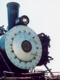
Canyon de Chelly - about 209 milesI will talk a little about each location, and tell you where the QUIET motels are. :)I used to go up there for physical therapy. They had one of the best therapists in the country, until local politics drove him out. While I was there, I would stay a couple of days and go see something. You may have seen a few of these photos in my other articles. The photo is an old steam engine on display in Flagstaff. All photos are mine.
Motels and Restaurants
The quiet motels are along Route 66 heading west from the Barnes and Noble. The others are along historic Route 66 parallel to Route 40... I never stayed in any of the motels along the latter strip, but if you want to do that, and experience some quiet, ask for a room on the BACK side. For the ones where I have stayed, since there is a rail spur around the hill behind them, ask to stay in the FRONT side.
Note this was some years ago, so things may have changed now. I decided to go exploring courtesy of Google Maps, and put the little person on the ground. Things look somewhat different these days!
So you're coming in from Phoenix along I-17. I-17 becomes Milton Road. When you get to a Y with a Barnes and Noble plainly visible, you turn left onto Historic Route 66. I used to stay at Days Inn. There is also a Best Western, but I never stayed there. When I was last there, Days Inn was a good and inexpensive place to stay.
Favorite restaurants included the Buster's Restaurant and Bar at 1800 South Milton Road. They serve excellent seafood, and is an upscale restaurant. If I was in a hurry, I'd grab a quick bite at Taco Bell at 1255 S. Milton. But I much preferred the Little Thai restaurant at Riordan and Milton. It's a little bitty place, so you might miss it the first time you drive by. It's in a strip mall. They had freshly made coconut ice cream, and it was very good! The other Thai restaurant I liked was Bangkok Thai Cafe, 2112 N. 4th Street. Lots of students eat there, and it was always crowded. I have to admit I never felt the need to go to a lot of different restaurants there, but there are scads of them. University students eat out a lot. I ate a few other places, too. Salsa Brava is good. They have lots of different kinds of salsa, which was a lot of fun. They actually have a salsa bar. Too bad I can't eat onions, because a lot of them looked tempting, but I could never try them. They're located at 2220 Historic Route 66. But be warned: they fill up bigtime on weekends and such. You may have to wait awhile. There is a wonderful steak place north a ways, at 8500 U.S. 89, the Horseman Lodge. I have to admit, I spent way too much money on food whenever I went there. There were just too many scrumptious places to eat! My mouth is watering just thinking about it.
Some years back I once went to Buster's, and the server took my check back to the smoking section, and I ended up stranded there with him gone with my check and credit card for about 10 minutes because they had given me the wrong check. After I got out, I had a coughing fit that lasted for 15 minutes. I told them about it, and they were most gracious! That made me love the place that much more. Since then, Arizona passed a law prohibiting any smoking in any restaurant, so it's no longer an issue.
Sunset Crater and Wupatki Ruins
Sunset Crater is probably the closest really well known scenic spot. It is believed that this last erupted about a thousand years ago. They have a cinder cone which is dark gray and red, and other places where you can see various kinds of lava. My memory tells me these were labeled with the Hawai'ian names, which is very helpful. It's not far and it's a beautiful drive. The road loops around to join the main highway, and along the way you will come to the Wupatki Ruins. The Sinagua (without water) people are said to have lived there. There are a few partly decayed buildings in the area.
If instead of turning right to go to Sunset Crater, you turn left at the very same spot, you will head toward Lockett Meadow. It's a quiet place, not well known (and really, it should stay that way). You drive along a dirt road for a ways, and you come to a place where you can turn right. You take that turn, and drive along that road, still dirt. It's all somewhat dicey. If you look to your right when you have gone up the mountain a ways, you will be able to see the Painted Desert on a clear day.
Lockett Meadow gives an excellent view of the San Francisco Peaks, complete with aspens in the foreground which turn a gorgeous gold in autumn. You can drive around the loop and go through the aspen area. There are also pine trees up there.
A Few Tempting Scenes
Click thumbnail to view full-size


More Fairly Local Stuff
Here I will show you some of the other places that are relatively close to Flagstaff. In some cases, I don't have photos, and in other cases, I don't know where the photos are, so when I find them, I will add them.
I have a few photos of Oak Creek Canyon, but I have been unable to locate them. The area is characterized, toward the top of the canyon, by pine forests, and along the way, there are forests with grasslands. I was able to get photos of some sheep grazing on the grass. More toward the bottom of the canyon, you can see tall rock faces, with more trees, and at the very bottom, you begin to see a few red cliffs, and you start to see into Sedona itself. Sedona is right at the bottom of the canyon. The picturesque road that goes from a place close to Flag, to Sedona, winds around, and is fairly short, and very enjoyable.
Wherever you travel there, even on the Interstate, watch for elk. They can be a real hazard. I never saw any on the highway, but I am told they do wander there. I have seen a few in the distance. They're bigger than deer. Many people know running into a deer can mess up a car pretty badly. You have been warned. :)
I also have photos of Jerome, Tuzigoot, Montezuma Castle, and Montezuma's Well. Montezuma Castle is a cliff dwelling, fairly small, and is accessed a short distance from Camp Verde, a sleepy little town with a couple of good motels and restaurants. It is also fairly close to Cottonwood, which also has motels and restaurants. It's a good place to stay if you want to be near Sedona for a day or two. The prices are much better in Cottonwood.
Montezuma's Well is slightly north of Camp Verde. It also has a cliff dwelling, and a deep hole in the ground with water. I saw a few Mallards when I was there, and a very tame squirrel that allowed me to take his picture and was not the least worried about me. He left when a woman with a dog arrived on the scene. Unlike the cliff dwelling at Montezuma Castle, this one is stretched out in a fairly lengthy horizontal crevice.
Even though Prescott is somewhat close, I didn't include it because it is a bit further (on the other side of the mountains from Jerome). Perhaps I will write about Prescott in a future article. It has its own zoo, which is unusual for a town that small. I don't know what the population is, but it's not very big at all. The zoo is really a rescue zoo, and only covers a couple of acres, but they have quite a few local species, especially snakes.
Many people think that it takes a long time for wood to petrify. Actually, it doesn't. It can happen in only a few years. What is needed is submersion in some kind of hot springs or other mineralized water. There are petrified logs in Yellowstone, and they are standing upright through many layers of sediment. If it took a long time for them to be petrified, and many years for the sediment to be deposited, the trees would have weathered and rotted away long before they ever turned to stone. When Mount St. Helens erupted, there was evidence that these layers of sediment can be deposited very quickly, given the right natural disaster, and after that, Yellowstone asked some knowledgeable geologists to re-write their descriptions of the petrified trees to reflect the fact that they turned to rock very quickly.
They did an experiment where they suspended some wood, by rope, into a hot spring in Yellowstone. Within four years, the rope had completely petrified, and the wood had partly petrified.
A canyon 1/40th the size of the Grand Canyon was carved out of the sediment deposited during the recent eruption of Mount St. Helens. It took only days to carve it.
Many geological processes happen much faster than we think they do.
More Photos of the Nearby Area
Click thumbnail to view full-size


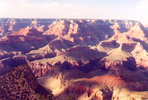
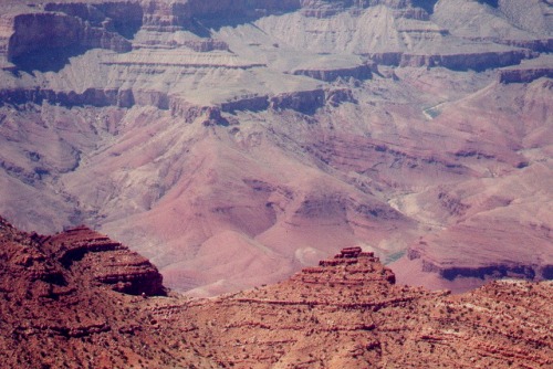
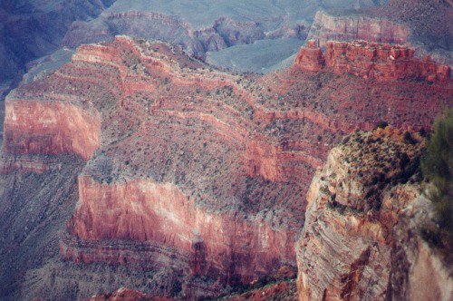
The Grand Canyon
Known as one of the original Seven Wonders of the World, the Grand Canyon is immense. It actually consists of one major canyon, with the Colorado River running through it, and many side canyons. It is a favorite tourist destination for visitors from around the world. In particular, the Germans and the Japanese like to visit. We owe it to the world to keep it open and accessible, and not let some government official shut it down for political purposes.
At the top of the canyon, it is very much a mountain climate, with various kinds of evergreens and shrubs, where they get lots of snow in winter. At the bottom, it can get quite hot. It is apparently quite a trip to get to the place where the Havasupai Falls are, and there is a small native community there. I have seen pictures, and the area is gorgeous. I just wish I can visit someday.
There are several theories on how the canyon was formed. The most well known one says that the Colorado River carved it out over eons. However, there are other theories. The one I favor says that at one time, there was a very large collection of water behind a natural earth dam. This was located "upstream" from the Grand Canyon. The layers of sediment that form the sides of the canyon were laid down quickly, and while they were still soft, the dam was breached, and all that water released. This water carved out the canyon with all its side canyons. I favor this theory for several reasons. One is the side canyons. One river doesn't carve out side canyons. It will at most carve out a gorge. Another is that some of the layers of sediment at the bottom are actually younger, as measured by radiometric dating, than some of the layers at the top. This makes no sense unless you accept my favored theory.
I first visited the Grand Canyon as a teenager. So when I went back decades later, I was quite surprised by some of the changes. The village has grown considerably. And you can no longer drive to the westernmost lookout. You have to take a tram. Unfortunately, we didn't know this in advance, and by the time we found it out and waited for the next tram, and it arrived, the sunset I had hoped to catch on film was largely over. I'll certainly keep that in mind when I go back.
On the north rim, there is now a new visitor type center with a balcony that stretches cantilevered over the canyon by quite a ways. I'm not gonna go there! I might visit the center, but I'll stay safely back from the edge, thankyewverymuch! But I imagine if that doesn't bother you, you can get a unique view of the canyon from there. I haven't been back to the north rim since I was a teenager. My recollection was of spending the night in a small cabin, and it was COLD!
On my second trip to the Grand Canyon as a teenager, my family took my grandparents. My grandpa had quite a sense of humor. When he got to the rim, he stood for a long time just looking into the canyon, and then he said, "Wow, it must have taken the Indians a long time to dig that hole!"
Lots of Grand Canyon Photos - Mostly self-explanatory.
Click thumbnail to view full-size


One More Photo for the Road

From Flagstaff, Moving on to Page
Page, Arizona, is near the border with Utah. It is right next to Lake Powell. Lake Powell was artificially created by constructing a dam. Unfortunately, many slot canyons were flooded, but that's all water under the bridge, so to speak, or over the dam if you prefer.
There are many attractions that can be easily reached from Page. My favorite is Antelope Canyon. I also like to photograph the lake, and one of these days, I will spring for a boat ride so I can get many pictures from elsewhere.
If you decide to visit Antelope Canyon, I recommend you hook up with Charly Moore. He is a guide for Overland Canyon Tours. You have to have a guide to go into Upper Antelope Canyon anyway, and both tour companies are good. But Charly is a very interesting person, and he will treat you right. He also owns an art gallery which has a very nice selection, and he does tattoos in the back of the art gallery (but on people's bodies, of course). I have seen the fantastic dragon tattoo he has on his back. Obviously, someone else had to do it, so there is more than one good tattoo artist in the area. Charly is originally from Germany. He also conducts tours into Canyon X. I haven't been there and I sure want to go. There are many slot canyons in the area, but most are closed to the public. They're on the land belonging to the Dineh Indians (Navajos).
Upper Antelope Canyon is only accessible if you are with a guide. Lower Antelope Canyon has an entry fee, collected directly by the Dineh, which was around $22 when I was there. You can have a guide if you want, but it's not required. Upper Antelope Canyon is a short walk, very level and easy going. Lower Antelope is more rugged, with places where you have to climb down a stepladder type arrangement, for example. When you get to the other end, you have to climb the equivalent of several stories of stairs to get back to the top.
If you can slog through some loose sand for a bit, you'll also want to visit Horseshoe Bend. It's a rather spectacular view of the Colorado River from above, where it doubles back on itself. It's just a little south of Page.
From Page, you can also visit the Vermilion Cliffs, and the Glen Canyon Recreational Area. If you go to Lees Ferry, you can take a road into the area, which is the only place along the Colorado River, for many miles, you can get right up to the river. It's a beautiful drive. You start by going up 89A into Dineh country, and drive around a loop. Just before you turn southwest, there is Lees Ferry. If you continue along the loop, however, you will drive alongside the Vermilion Cliffs for many miles.
If instead you want to see places like The Wave, you will need a permit. These are hard to get. I think they have a lottery these days because so many people want to go there, and they only hand out less than a dozen permits per day. Since there is no assurance you'll get one, it can be difficult. Back when I applied, you could apply on the web site, and the permit would arrive in the mail. There wasn't too much competition. Taken days were simply blocked out on the calendar. Unfortunately, our car broke down, so we didn't get to go there. But there are plenty of other places in the area where you can see very similar things. That's one reason why on the day we couldn't go to Coyote Buttes, Charly took us to Waterhole Canyon instead. I don't remember exactly how to get there, unfortunately. But it was an excellent place to visit.
From Page, you can drive on up into Utah. There are three main attractions that are within reasonable distance: Zion National Park, Bryce Canyon, and Grand Staircase - Escalante. On the way to Bryce Canyon, if you go from Zion, there is a lesser known park known as Red Rock Canyon. You might want to stay a night or two in Utah. I did. The first time, I stayed in a little town just west of Zion, and the second night I stayed in a little town halfway between Zion and Bryce.
My recollection is that it is a VERY devious route to Zion. My memory tells me I stayed in St. George. I stayed in a little motel I can't remember the name of, but the woman who helped me (one of the owners) was EXTREMELY helpful, and I would go back there any time. I would recognize the place when I see it. I took Route 9, which goes through the tunnel in Zion, to get there. From there I went back to Highway 89, to go to Bryce. I stayed in Hatch, which is about one traffic light or two, if that. There is a group of cabins on the south end of town, where I stayed. They have a little restaurant, and the food is not too bad. It was very cold there, even though it was May, and I about froze my fingers off getting into the building. I was lucky they let me stay in the main building where the restaurant is, because I didn't have to go outside until I was ready to leave in the morning. The waitress there treated me well and gave me some interesting conversation. I got to stay upstairs where it is warmer. If you need to call home, the only phone is out on the porch where it's cold. Fortunately, I was able to get cell phone reception there.
Be aware that Bryce Canyon is really more of a mesa than a canyon. It's like a canyon on both sides, of which the east side seems to be the one people explore. The altitude at the top is around 9000 feet, so the air is a bit rarified if you're not used to it. The cold (with snow on the ground in May) and the altitude made walking difficult but I did a little anyway, climbing a small slope in one place. I didn't dream of taking any trails down into the lower areas.
Grand Staircase - Escalante is a relatively new wilderness area, closer to Page. The road into the area leads to Grosvenor Arch. It doesn't look like much from the road, but it's actually a fairly good sized arch. It's an interesting drive, and there are lots of nice shady places where you can stop and have a picnic.
The people in Utah are friendly to strangers, and the roads are relatively terrible. The roads wander allovertheplace, so there is no straight route to just about anywhere.
Because of the roads, these locations are best seen working out of Page, but to get to the rest of the places I will discuss, the shortest route is to take Highway 98 from a place just outside Page, and hook up with 160, and then turn north on 163, to get to the rest of the places. There is very little lodging up there until you get to Moab. I suspect that the one motel I know about near Monument Valley would charge you an arm and a leg because they can get away with it. If you prefer, you can stay in Chinle, near Canyon de Chelly. That's a trip in my future. Moab had motels and restaurants, so there's no real problem to stay there.
But go to Monument Valley first, before going to Chinle. Then you can backtrack to US 160, and go until you can turn north onto 191. This will take you to Moab. If you want to stay in Chinle, you go south a bit, stay there, and then backtrack up to 160, where you jog east to get on 191 going north.
There are two major parks in the area around Moab. I had the opportunity to go to Canyonlands, but Arches is in the future.
Lots of these roads are just two lanes. It's an interesting and scenic drive, but you will be forced to go more slowly and truly savor it, because you might as well.
Be sure and map out your itinerary, especially your routes, well in advance. Otherwise, it would be easy to get hopelessly lost! And I suspect the information I have given you here is confusing as heck! My apologies. It's been several years. I wouldn't have any trouble doing it again, but telling other people how to do it is another matter.
Western Arizona-Utah
Click thumbnail to view full-size


. Scene from the parking lot of my motel toward the Vermilion Cliffs.")


. Scene from the parking lot of my motel toward the Vermilion Cliffs.")


Travel Poll
Where have you been?


Eastern Arizona-Utah
Two separate trips into this area got me two different destinations.
The first is Monument Valley. This is a tribal park belonging to the Dineh, and the setting for many western movies. Hoodoos, mesas, and buttes will probably look familiar. I tried to go during a time of the year when there would be clouds, but as it turned out, it got heavy with clouds soon after I arrived, so it was a dreary day. In Arizona, the summer rainy season (wet summer, the second half of other people's summer) yields nice clouds at least on some days, and wildflowers up in that area, in August.
The other place I went was Canyonlands National Park. That place is huge. It took me nearly all day just to drive the two roads that go into the area (one on the south and one on the north) and there was a separate, shorter road I never got to before nightfall took over. I was hoping to see another place where the Colorado River doubles back on itself, but I never found that place. I think I know where it is now, and when I go back to see Arches, I'll look for it. It is a good to plan one night in Moab ("Moh'-ab"). There isn't much else by way of accommodations anywhere else in the area, although I found a really nice steak restaurant close to the border between Arizona and Utah, which I couldn't find the second time I drove through, unfortunately. Because of time and budget constraints, after spending the night in Moab, I had to go back home.
There are many other parks in Utah, so if you have plenty of time, you can visit many other places as well. From Flagstaff, it is wisest to go on to Moab and establish a beachhead there, to explore the area.
It's a long drive from there back to southern Arizona, but I did it in one day.
I have never had the opportunity to visit Shiprock, New Mexico, but it is also in that area, obviously reached by more winding narrow roads.
Shiprock and the White Sands are the two places in New Mexico I long to visit.


Wrapping Up My Thoughts
This is just a bare sample of the beauties of this entire area. I hope you found your visit intriguing and pleasant, and perhaps will want to explore the area for yourself. There are many other places I haven't even touched on, most of which I haven't seen myself.
Should you go, have a good trip!
For Further Reading
Selection from Amazon
I am sure there are lots of coffee table books about these places, but finding them on Amazon isn't altogether trivial.
These are books that caught my eye while browsing. The first is actually a map, which you might find quite useful if you want to explore some of the places I have been.
Canyon Country National Parks Map: Grand Canyon, Zion, Bryce Canyon, Arches, Canyonlands, Mesa Verde, Capitol Reef, and Great Basin
by ccnationalparks.com
Travels to the Edge: A Photo Odyssey
by Art Wolfe
Creative Nature & Outdoor Photography, Revised Edition
by Brenda Tharp
Galen Rowell's Inner Game of Outdoor Photography
by Galen Rowell
Related

Visiting the Fabulous Oak Creek Canyon, Slide Rock State Park and Sedona, Arizona

The Colors of the Grand Canyon

Pulau Pinang Tourism Highlights

The North Rim of the Grand Canyon Arizona and the Grand Canyon Lodge A Less Crowded Experience

The Museum of Northern Arizona and Other Places to Visit in Flagstaff Arizona