Weather Ahead

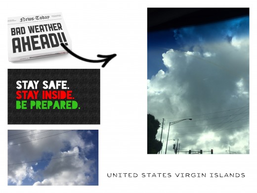
Watch Out for Hurricanes in the Caribbean Atlantic Ocean
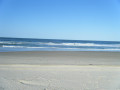
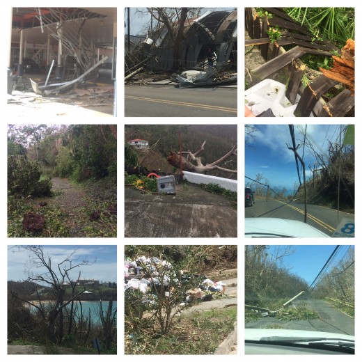
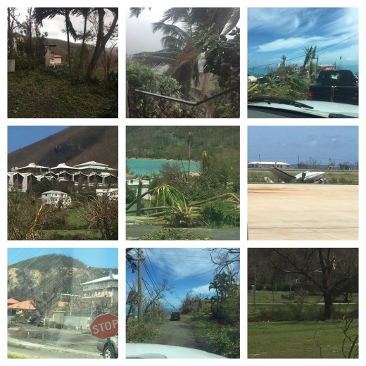
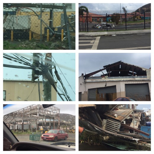
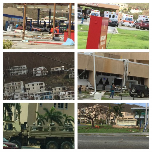
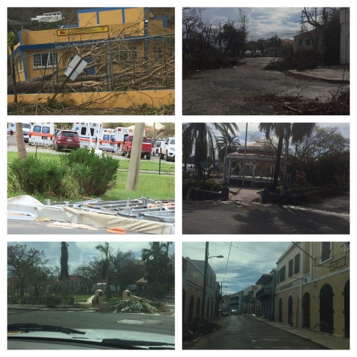
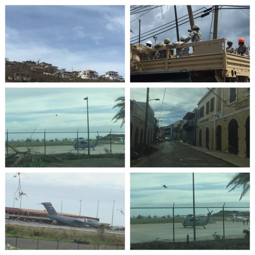
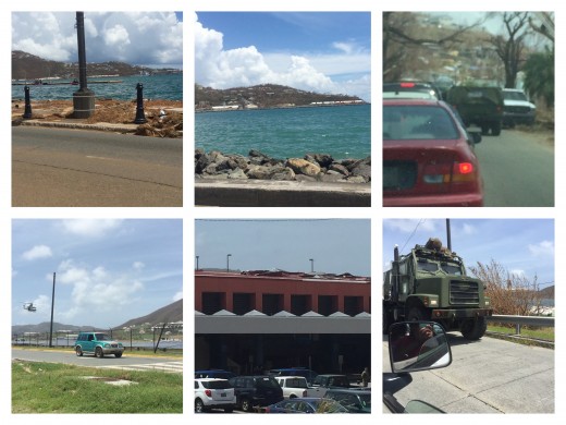
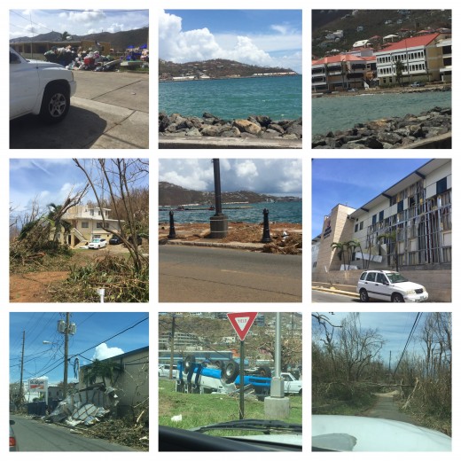
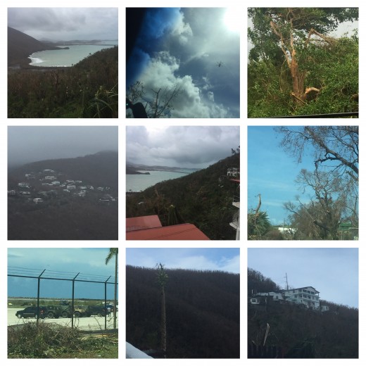
September is the highest hurricane watch for the United States Virgin Islands. In the year 2017, the Islands gotten back to back catagory 5 hurricanes. A massive hurricane Irma came in with a swifting wind speed with gusting at 185-220 strength, heading directly to the island on September 6, 2017 as it distoyed almost everything in it's path, broke down poles, trees and many homes and business was distroyed. Then two weeks later, hurricane Maria on September 15, 2017 with high speed at 165-187 winds and rain as the hurricane shifted and scrabble what was already into pieces and took more homes and business to its last standing. The islands was devestatingly flooded and scattered with broken trees, lifeless aniimals and debris. See pictures and videos of what the power of a hurricane can do, it is imperative that we follow the ground rules in Preparations and Safety.
What is a Hurricane?
Hurricanes are high pressure of intense encircling belt cyclopean. That forms amount of heat that releases cloudy diffused matter. It is vapor that evanesce from the ocean and condenses to heavy rain falls and strong winds. The hurricane forms a vortex guide upper air currents spinning clockwise.
Important Preparations
At all means necessary you must prepare for a hurricane before it reaches in it's path of devastation. For people that are vacationing on the island during the hurricane season, please plan ahead. If you may, try not to plan your vacation in September on the United States Virgin Islands. It is a very critical time during the hurricane season.
Tips for vacationers
1. Make sure you have cash money$
2. Have boots and extra cloths, long sleeve and long pants.
3. Purchase bug repellent.
4. Ziplack all your important documents, ID, passport, etc and keep it at hand.
5. Carry a battery small radio and extra batteries.
6. Flashlights
7. Bottle Water and snacks
8. A pocket knlife and hammer
9. Emergency medical kit, bandages, cough and cold medicines
10. A cellphone with At&t services.

Hurricane Trade Winds
Trade winds are the most extensive wind flow westward in the direction of the equator. As the trade winds progresses. The air mass transfigure humid and dissipated rain clouds. Independently, the wind rate indication in pressure as an alternative of atmospheric motion. Its pressure is equivalent to the refine of air preposition on the earth's atmosphere or surface.
How strong can a Hurricane get?
Hurricane winds may adept a pressure of more than 400 kilogram per square metre to 82 pounds per square foot winds. However, it can destroy everything in its path. A hurricane can export more than 3,500,000,000 tons of air per hour. A hurricane is very serious and every year it gets stronger and more intense. Our lives depend on proper coverage in time of hurricane season.
How can you be certain it's a strong hurricane?
Times of technology online or broadcasting weather report from professional radiologists are prepare to give reports that are very important to listen and take proper precautions. Stay out of harms way when these reports are broadcast, it is real and accurate to its safety measures. When you hear or read a storm of hurricane measures, thats when you will know a hurricane strength.
Hurricane are a form of stormy weather off of Africa or South America till it accumulates over the ocean forming latitude of trade winds in the tropical water at a low pressure near the equator margins. The hurricane centreas of high pressure that may elongate subtropical areas into the middle latitude.
Hurricane emerges air characteristics that generate very warm, dry conditions with ample sunlight found in the eastern extremes of subtropical atlantic ocean basins.
Hurricane Kinetic Energy
Kinetic energy wind speeds and gust are predominantly strongest storm derived from the heat of the ground by the sun that causes subvert of the air, which descending currents conserving the impetus of high altitude winds from cold air and the rising of warm air, however, causes the stationary front.
Kinetic energy is known for its moving motion of wind speed. For example when riding a bicycle down hill as you coast downward. The wind speed pushes the cycle with altimate wind speed, if you hold breaks it stop the pressure going at it's fastest down hill, but if you go up hill it give more cycle pressure to its wind speed to peddle up hill, so the kinetic energy changes to its motion wind speed in pressure. That's what a hurricane does when it hits land verses out in the open where the ocean feeds its strength moving in its Kinetic motion heading towards landfall, however it can slow the process up hill in cycle of strength and fasten the process in down hill on a bicycle example.
The front between mass of warm air and less dense than cold air atmospheric pressure. The warm front defuses and difficult to locate because it often move slowly and quite.
Hurricane Air Mass
Air mass level of altitude have practically uniform large body of air conditions of tempative and humidity. Air mass forms when the atmosphere balance permits a large tempreture and moist properties of that surface. The stature of air mass emanate in subtropical latitudes. However, the coolness and dryness of the air mass that moves to lower latitudes modifies rapidly in the summers, which the low stratus clouds widely scattered rain falls and possible thunderstorms.
How do clouds form in a hurricane?
Clouds form by damp air which cools by lower pressure that exists at high levels in the atmospher. They form in regions of upward impetus if sufficient moisture are present and dissipate in this of the downward impetus. The widespread layer clouds conjoin with tropical derpressia, which the layers of clouds are formed by the widespread anomalous motion or turbulence. Then the cumuli clouds forms by admittance convection and the prographic clouds form by an upward incline air over hills and mountains. This prominent clouds, warm, moist maritime tropical air forms over tropical and subtropical ocean waters with high pressure.
Hurricane Sea Levels
Hurricane sea levels high and low pressure centres are caused by differential latitudes between Atlantic and Pacific ocean, which the atmospheric pressure and horizontal wind that changes in wind direction and speed to capitullate mathematical zonal and meridi wind speed. The angular velocity of the earth rotation latitude, air density (mass per unit volume), pressure and distance towards the earth directions. The geostrophic balances sea levels and capitulate mostui field winds.
Hurricane Jet Streams
Jet Streams are vigorous winds that are upper air circulations at a surfeit of 30 meters per second, it modifies thermal winds equation above areas of exceedingly sturdy temperatures gradients frontal zones. Which induces wind speeds that aggrandize heights temperature gradienst in the same direction, frequently can hinder in forecasting changes in air mass, hence in temperatures and weather aloft regions. These jet streams forms a sigh band in high latitudes by sporadic periods of conversation. However, it is an important factor in high altitude jet flights to navigate through wind speed and time in reaching its flight destination in weathering report system.
What is the Rossby Waves?
The Rossby waves are important to the measure of intensity of rotational motion from the easterly and westerly winds. The natural prodigy in the atmosphere and ocean properties in rotation of the planet. It's a mathematical set of inertial planetary waves that has a natural form when the air transmit heat and locomotion to the equator. The Rossby waves Jet Streams are the meanders in the upper wind belt and strong ribbons of wind in the westerly circulation.
Eddies in the Ocean
Eddies are fluid currants that flow direction that differs from general flow to movements that transfer larger amounts of energy matter, within the fluid molecular diffusion, which also called turbulent. It modifies more multifarious fluids in derive momentum to amplify puissance, that can shift from large to small eddies until it dissipates. Eddies anomalous to general circulation of tropical hurricane at the lower intensified hurricane at the mid westerly wind belts, which is an important role that are tenable to the global atmosphere circulation.
Shutters
What seasonings to use for your MRE Rations?
That help food can taste yak, but there is a seasoning that you can use to give it a sensible taste. It's called ADOBO. made in Puerto Rico.
Strap your car

Emergency Food

© 2019 Delia Almestica