Natural Disaster list - In 2011

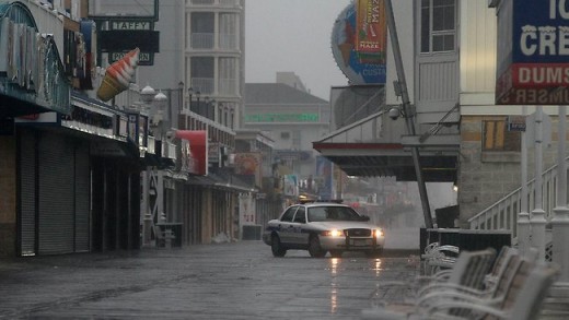
Hurricane Irene
We are thinking of everyone in the path of Hurricane Irene on the East coast of USA at the moment as many are evacuating their homes & businesses for safer ground.
As there are fears that subway tunnels could be flooded, as well as the impact of power cuts, the final trains and buses left depots at noon local time (2am AEST).
Airlines have also scrapped more than 9000 flights over the weekend, from North Carolina to Boston, grounding passengers as Irene sweeps up the East Coast.
"It's conceivable that there'll be no electricity as well as a lot of water in the streets. Let's stop thinking this is something to play with. Staying behind is dangerous, staying behind is foolish and against the law. The time to leave is right now." - New York Mayor Michael Bloomberg
Christchurch Earthquake 2011
It was sad to see Christchurch where I spent 7 years growing up suffer such a dramatic devastating earthquake and lose so many family members
We would walk up to the square occasionaly , see the wizard on his box, climb the stairs off the cathedral to look out over the city.
We are thinking of you all in Christchurch & your families wherever they may be.
And now Japan is suffering as well after a major earthquake and our thoughts are with you as well at this time.
I used to live down the road from here


My Daughter Evacuated From Work in Brisbane
I have a daughter living in Brisbane ( the one I talked about in Where are the children ) who was evacuated along with many others out of the city as well as my sister & neices who live in Ipswitch that looks like it is going to be flooded.
I have talked to my daughter & she is ok at the moment up in the hills.
We have other people we know in the area and we are thinking of you all as well as everyone we don't know.
We are all thinking of you at this time.
I really feel for those who have lost loved ones in this flood and others .
Reminds me of watching the flood in New Orleans years ago.
Natural Disaster - 2011

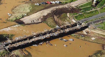
Grantham Bridge
Lives lost, children missing as deluge hits Toowoomba and the Lockyer Valley
AUTHORITIES expect to find more bodies in Queensland communities torn apart by flash floods that have so far killed eight people and left 72 missing.
Dozens of survivors remain stranded in small communities in the Lockyer Valley, west of Brisbane, after it was hit by walls of water that earlier ripped through Toowoomba.
A massive effort involving defence helicopters is underway to reach people stranded in the devastated towns of Grantham and Murphys Creek, where bodies have been found, and at Withcott.
Atrocious weather is continuing to lash affected communities, and Queenslanders have been told to brace for more deaths.
Grantham Bridge
Perched on the edge of the small rail bridge that dissects Grantham a big black bull, entrails hanging out, has come to his final resting place, surrounded by fridges, toys and every imaginable domestic possession that was forced against the buttresses by the surging water. ''I just hope that it's only the cow that's causing the smell,'' said local Pat Thorpe forlornly. ''But I'm afraid there'll be lots more loss of life.''
Grantham has always been a town divided, first by the brown waters of Sandy Creek and then by the railway line.
But now tragedy is also separating those who live on the higher western side, where houses remained mostly unaffected, and those on the east.
''Things have just been totally flattened, homes completely knocked to the floor, it's total destruction over there,'' said Ken Harme, who has lived in Grantham for 30 years.
On the eastern side 15 more police officers, supported by a team of firemen, began searching through the properties.
One house had been washed more than two kilometres by the floodwaters from its block and now sits in the plains outside the town.
Carnarvon Floods
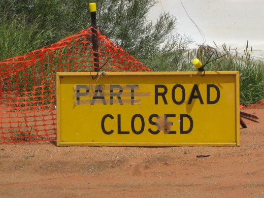

No Go Areas in Queensland
No-go areas are either currently affected by flooding, anticipated to be affected by flooding or closed to all traffic. Danger zones are areas that travel should be limited to unless essential. If essential, drivers are to proceed with extreme caution. Please also consult other road closures as detailed below for your region.
The following roads are no-go/danger zones for travellers:
- Barwon Highway - west of Goondiwindi
- Bruce Highway - north of Gladstone
- Bruce Highway - south of Gympie
- Canarvon Highway - north of Injune
- Dawson Highway - Calliope to Springsure
- Fitzroy Development Rd - north of Taroom
- Leichardt Highway - north of Wandoan
- Moonee Highway - west of Moonee
- Warrego Highway - west of Dalby
- Are You Prepared If A Disaster Hits Your Home ?
Sadly in 2011 so far there has been a run on disasters with the Queensland, WA floods , Christchurch earthquake and now Japan amongst others. Are you prepared if a disaster were to come your way ? We don't...
11.1.11 A sad Day for Brisbane
- DMR - Traffic & Travel Information - Static
No-go areas are either currently affected by flooding, anticipated to be affected by flooding or closed to all traffic. Danger zones are areas that travel should be limited to unless essential. If essential, drivers are to proceed with extreme cautio

Floods in Lake Erin
- Toowoomba hit by flash flooding - ABC News (Australian Broadcasting Corporation)
Two people are missing and dozens of rescues are taking place after Toowoomba was hit with torrential rain this afternoon, causing flash flooding and landslides.
Carnarvon Flooded Again
- Carnarvon - A Friendly Place To Visit
As we drove up from Monkey Mia,Denham towards Exmouth We came across Carnarvon 904km north of Perth. The largest town in the Gascoyne region, Carnarvon offers sparkling beaches, brilliant displays of...
Emergency Kits Everyone should have one

First Aid Vital in Emergencies
- First Aid Courses in Australia
On Friday I walked into my work colleagues house to finalise plans for our seminar that evening . As we walked in I noticed his partners 17 yr old son laying face floor on the ground. At first we thought...
Shelves of bread are stripped almost bare by shoppers at Jindalee nearly 13km from the Brisbane city centre as residents stock up on essentials. Picture: Supplied. Source: HWT Image Library
Shoppers cleared this Coles supermarket of bottled water amid panic buying.
UPDATE 2.43pm: SEVERAL Brisbane suburbs told to evacuate as waters rise in the city, triggering pandemonium in supermarkets.
Up to 32 Brisbane suburbs are expected to be affected as flood waters begin rising in the city amid concerns for its huge dam.
A wall of flood waters is heading towards Brisbane, with residents warned to prepare for a major flood and parts of the CBD being evacuated, including businesses.
Caboolture, north of Brisbane, is already isolated by floodwaters and police have told all residents in low-lying areas to immediately move to higher ground.
Strathpine residents also to the north have been told to go, while inner-Brisbane suburbs New Farm, West End, Fortitude Valley and Bowen Hills have also been ordered to evacuate.
One Brisbane mum told the Herald Sun that it was "pandemonium" at local supermarkets as residents raced to stock up on essentials, with shoppers clearing out bread, bottled water, vegetables and other essentials such as large plastic storage containers.
Residents to the north and west of the city have also been told to shift to higher ground.
Those affected include residents near the Brisbane River at West End, in the inner city,
Office towers on Eagle Street are being emptied, along with businesses in Fortitude Valley, and flood waters are creeping into the inner-city suburb of West End, where residents have been told to get to higher ground.
Evacuations are also underway on Brisbane's northside at Albion and Bowen Hills, the ABC reported.
Car parks in Brisbane's CBD have opened their boom gates and advised people to get their cars out.
High tides are expected to strike at about 1.30pm, wreaking further havoc.
And as the waters rise several barges and pontoons have broken from their moorings and are floating down the Brisbane River.
The rising floodwaters have also cut train services north and west of Brisbane.
Southeast Queensland's public transport operator Translink has closed the Ipswich to Rosewood train services and there are no trains north of Burpengary to Caboolture and as far north as Gympie.
"There are no trains beyond Ipswich and no trains between Burpengary and Gympie,'' a Translink spokesman said this afternoon.
"Strong currents in the Brisbane river has also caused the cancellation of all river cats and ferries.''
He said buses in Caboolture and the Redcliffe area have been cancelled and a limited number of bus services in Ipswich but most bus services in Brisbane are still running.
"There are a lot of disruptions and there will be lengthy delays in bus and train services,'' he said.
CityCat and CityFerry services on the Brisbane River have already been suspended.
Earlier, the Brisbane City Council has released a list of 32 at-risk suburbs and says 200 properties could be flooded, most in the areas of Rocklea, Albion, Milton and Auchenflower.
Premier Anna Bligh said urgent modelling is being done to determine how the Toowoomba deluge would affect the situation in the capital, and west at Ipswich where evacuation alerts are also in place.
Anna Blight speaks on Qld flood crisis
An emotional Queensland Premier Anna Bligh explains the tough challenge of coping with the state's floods amid difficult weather as the death continues to rise.
She said the water that fell in the Toowoomba area would move into the catchment of the Wivenhoe dam, and from there it must be released, at a controlled rate, into the Brisbane River.
Releases from the dam are being ramped up to cope with the enormous volume of water its holding back.
"Releases from Wivenhoe are not optional, there is no discretion here," the premier said.
To Brisbane's west, the city of Ipswich is also in evacuation mode, with the council warning people close to the rising Bremer River to move to evacuation centres.
And in the Lockyer Valley, already hit hard yesterday by flash flooding, further flash flooding alerts are current for Forest Hill and Laidley, with both of those communities being evacuated amid rapidly rising waters.
Evacuations have also been ordered for Toogoolawah and Esk.
Other places facing floods include Gympie, Maryborough, Moggill, Jindalee, Pine Rivers, Amberley, Walloon, Rosewood, Kalbar, Boonah, Kilcoy and Aratula and through a wide arc south including Stanthorpe and NSW border areas.
Weather Bureau forecaster Peter Baddiley warned of fast river and creek rises west of Brisbane as flood waters from the Lockyer Valley and surrounding catchments move east.
He said low lying area near creeks and rivers faced fast river rises as water moved from those regions into the Brisbane area.
“We've got a continuing high but narrow rainfall band and are warning residents to move away ... to higher ground,'' he said.
“We're not talking flash floods here (like Toowoomba). This will be over a slower time scale and the river will continue to rise for several days.''
At the Brisbane city gauge, moderate flood levels of 2.6m are expected with the overnight high tide.
As the disaster continues a body of floodwater larger than Sydney Harbour threatens Brisbane, with only the Wivenhoe Dam's 2.3km-long earthen wall standing in its path.
Brisbane Lord Mayor Campbell Newman warned yesterday that more water was flowing into the dam than the Brisbane River had received in the 1974 floods.
The Brisbane City Council last night issued a warning for residents in more than 30 suburbs to expect flooding.
Wivenhoe was rising fast, but it had the potential to go past 200 per cent capacity before overflowing. Cr Newman said the dam was doing its job but could not fully protect the city because of the dimension of the floods.
Wivenhoe holds 1,728,590ML the most it has ever held and faces its greatest test as a city flood mitigation project since it was built after the 1974 floods.
The 1.45 million ML flood compartment is close to half full, with managers yesterday scrambling to increase releases from 116,000ML to 170,000ML a day as rain fell in its 7020sq km catchment. It also holds a further 1.17 million ML of drinking water supplies.
SEQ Water Grid spokesman Barry Dennien said Wivenhoe peak inflows had hit 1,032,000ML per day. Somerset Dam inflows were about 360,000ML per day.
"Considering Wivenhoe's flood storage compartment holds 1.45 million megalitres, at this rate the compartment could fill within 1.5 days," Mr Dennien said.
Peak flows varied depending on rainfall but releases under way will provide relief from the inflows.
Under conservative operating rules set by State Parliament, managers must empty the flood compartment within seven days to prevent a second flood.
The combination of heavy rain, dam releases and higher than usual tides meant the river could rise significantly. The biggest impacts could be felt tomorrow and particularly Friday week (January 21) due to a king tide.
"This is currently the projected worst-case scenario for the next few days, and I hope it doesn't happen, but people need to be forewarned so they can prepare themselves for flooding," he said.
The 30 suburbs expected to experience flooding had been predicted to include: Albion, Auchenflower, Bowen Hills, Brisbane City, Bulimba, Chelmer, Coorparoo, East Brisbane, Fairfield, Fig Tree Pocket, Fortitude Valley, Graceville, Hemmant, Indooroopilly, Kangaroo Point, Lytton, Milton, Moggill, Murarrie, New Farm, Newstead, Norman Park, Oxley, Pinkenba, Rocklea, Sherwood, South Brisbane, Tennyson, Yeronga, Yerongpilly, Windsor and Wacol.