Hike Snead Farm Trail in Virginia's Shenandoah National Park

Snead Farm
To get you thinking about hiking
When is your first hike of the year? (Usually)
Snead Farm or Fox Hollow: A good leg stretcher either way.
It seems that during the Winter months, I tend to get out of shape, especially the older I get. For this reason, I eagerly look forward to the return of pleasant weather, so I can get outdoors and once again exercise the heart, lungs, legs and joints.
Over the years, I have learned that if I over-exert myself on the first outing of the season, my body will protest for several days afterwards.
The past several years, for the first hike of the season, I have parked my car at the Dickey Ridge Visitors Center in Shenandoah National Park and used the Fox Hollow Nature Trail as my first hike of the season. This year, I parked in the same spot and followed the Snead Farm Trail instead. The biggest difference is that when I got to the trail-head, I turned right instead of left. Both trails are relatively short and have mild up and down hills. The trail to Snead Farm probably has fewer steep parts and more level parts than Fox Hollow Nature Trail, but both are good ways to exercise without straining yourself, while still using your muscles, heart and lungs.
Two other hikes in Shenandoah National Park
- Hiking trail Guide: Compton Peak in Shenandoah National Park
Compton Peak is well worth the slightly more than a mile hike to reach. This article describes the segments of the main trail and the two side trails and, using words and pictures, illustrates the view from the top. - Hiking Trail Guide: Fox Hollow Nature Trail in Shenandoah National Park
I am a hiker who lives near Shenandoah National Park and every year I seem to be a little out of shape at the beginning of hiking season. The Fox Hollow Nature Trail is a good way to get back into shape without over-doing it. This article will explai
On the way to the farm
The trail to the right starts off heading downhill. At the junction, there will be a post. Bear off to the right towards Snead Farm. At the entrance to the trail, there is often a pile of what look like branches. These come in handy as walking sticks. I sometimes grab one, use it along the trail and return it when I get back. If you are unsure of how stable you are on these surfaces, it won't burden you much to take one and it may save yourself from stumbling.
The trail continues a gradual descent. It will be a mix of level walking and a few small but at times, somewhat steep hills. The downhill and level stretches build your confidence and help you stretch the leg muscles and draw fuller breaths. The uphill sections may remind you that you haven't done this in a while. But don't give up. They are only temporary and soon you will be back on level or gradual downhill surfaces.
The trail is a fairly smooth, dirt surface at first. Then, you come to a gravel road, at which you bear left for a little ways until you see another junction and post indicating the way to Snead Farm and the road returns to it's dirt surface. If you choose to take the trail that makes a steep climb up the side of the mountain, it will take you to the summit of Dickey Ridge. I have taken that trail coming back from Snead Farm, but have not yet taken it to get there. The rest of the way to the farm, it looks like you are on an unpaved but well maintained surface with several small hills. While the first part of the trail was highlighted by trees, this segment has the trees further away from the trail and even the occasional markings for water lines.
This part of the trail has a few more areas of overlooks, one following power lines down the side of the mountain and the view of homes miles off in the distance.
At the farm...
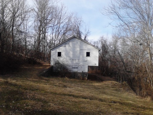
About .8 miles from where the trail starts, you will be walking along and notice, off to your right, the huge white building pictured at the top of this article. You have arrived at Snead Farm.
While it may be hard to imagine now, the area that is now Shenandoah National Park, when it was formed in the 1930s was, according to http://www.visitshenandoah.com/shenandoah-history.aspx, home to approximately 460 families when the park was established in 1926. Shenandoah National Park was pieced together from over 3,000 individual tracts of land, purchased or condemned by the Commonwealth of Virginia and presented to the Federal Government. The buildings and foundations are not historical re-creations. They are what remains. People lived in that area, farmed in that area, worked in that area, and, as in the case of the family that lived about 2 miles away going down what is now Fox Hollow Nature Trail, people were (are) even buried in the National Park in their family cemetery. Remember that as you look around and walk around what is left of the farm house.
The main barn building itself is the prominent feature at this site. You can only see the outside of it. The entrance is locked, though small animals and insects can probably get in from the looks of the door. When I arrive at the building, I like to walk around the building counter-clockwise starting from where the trail passes near it. Doing that, the door I just described is on the other side of the building. Once you turn around, you will see, camouflaged, another, much smaller building. This was a root cellar. A few yards away, it looks like there is a foundation to what may have been another large building, likely a house. The most notable feature over there is a very large tree. If there has been adequate rain or snow fall, you may have to step across two small flows of water.
More photos of Snead Farm

")


Summary
Overall, this is a fairly easy trail, and a good way to get back in shape. The total, round-trip distance is 2.6 miles. It took me about 25 minutes to get to the farm, about 20 to get back, and I spent about 10 minutes walking around and looking around while I was there. The hardest part of the whole hike is at the very end, after you walked it, having to walk up the hill toward Skyline Drive and the Visitor's Center. Remember to save some strength for that and enjoy your walk,
All the details of a recent hike and a tracking App.
- Track your exercise with Endomondo: There is an App for that.
The Endomondo fitness tracking App for the cell phone gives the user immediate feedback of the benefits of their exercise and it also keeps records of these workouts for their own use and to share if they so desire. It enables something that can be d - Hiking Workout | Endomondo
Tom Vogler was out hiking 2.57 miles using Endomondo.
Are you up for a challenge?
There are two ways you can make your hike on the Snead Farm Trail more challenging.
Challenge #1 would be to first hike the Fox Hollow Nature trail, then at the end of that, instead of returning to the visitors center directly, hike the Snead Farm Trail. That combination is not overly strenuous but it covers about 5 miles.
Challenge #2 would be from the Farm, follow the Dickey Ridge Trail. Just beyond the barn, there is another trailhead access. Following that will lead you up and over the top of Dickey Ridge. If this is your first hike in a while and you are out of shape, this trail may be quite a challenge for you. This trail has somewhat steep elevation changes, but, as is often the case, the view from up there a few hundred feet higher may be well worth the effort. At the top, there is a large tower, as well as a somewhat hidden area that is used by hang gliders as a launching area. The trail then descends and once again intersects with the Snead Farm Trail heading back towards the visitors center and your vehicle.
Other fine outdoor hubs
- Climbing Life's Mountain
Metaphor of life's struggles compared to a mountain climb. - Pedaling Across the Allegheny River on the Sandy Creek Trail
Just south of Franklin, PA, but not very easy to find, the Sandy Creek Trail winds 12 miles from Fisherman's Cove in the west to Van in the east. Along the way the trail crosses 7 bridges including the 1385 foot long Belmar Bridge over the Allegheny


