A New Hampshire State of Mind

Okay, I’ll admit it, I was wrong. Right now you’re asking yourself “What is she wrong about?” See, I’m a landscape photographer and many photography magazines contain articles about the beautiful autumns in New England and in particular New Hampshire. I thought often “Oh come on, we here in Ohio have some outstanding autumns too.” I was wrong, seriously wrong. I’ve never seen so many shades of reds, oranges and yellows. I gazed at the colors realizing I never truly seen autumn colors until I visited New Hampshire.
First Few Days
My destination in New Hampshire was the White Mountains. White Mountain National Forest encompasses 784,505 acres of pristine, mountainous, forested land in North Central-Eastern New Hampshire and a small area of Maine. It’s the only national forest located in both states. Whenever I travel to a place, whether it’s a national park, forest or state park, I usually stay in an area where there’s easy access to the main attraction, Lincoln, fit the bill perfectly. Located in the western area of the White Mountains National Forest (along Interstate 93). Lincoln isn’t your typical tourist trap towns usually found around large attractions. The White Mountains National Forest Visitors Center is located here along with several markets, restaurants and other convinces for us tourists.
Unfortunately, the first couple of days proved futile in my attempts to photograph the mountains. Unbeknownst to me, it’d been raining steadily for several days. Rivers and streams were swollen; the skies were shrouded in constant fog. Instead of concentrating on the great expanse of the White Mountains I would begin my photographic journey by “focusing” on the intimate landscapes of the rivers and waterfalls (of which there are many to choose from) beginning with the Basin area.
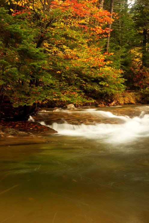
Basin-Cascade Area
Located along the Cascade Brook, the Basin-Cascade trail is a “warm up” for many of the more strenuous trails found in the national forest. A total of two miles from the Basin to Rocky Glen Falls, the trail meanders through the Franconia Notch area (which I will visit again later in this article) of the national forest. Highlights include the Basin, a small vortex created by the Cascade Brook. Various unnamed waterfalls can be found here created by a series of boulders and rocks in Cascade Brook. Kinsman Falls, a beautiful out-of-the-way waterfall surrounded by flatten boulders and ledges giving the visitor a great view of the falls. Finally, Rocky Glen Falls, the final waterfall found along the trail. Cascade Brook drops thirty - five feet over two parts of jagged rocks between narrow walls into yellow pools. Only the bottom of the waterfall is seen from the Basin-Cascade trail. In order to view the entire waterfall in all its glory you must continue to hike upstream another one hundred and fifty feet, cross a bridge across the stream and hike a short distance down stream until there it is the top portion of Rocky Glen Falls.


The Crawford Notch Area
I was still craving more color, but the weather wasn’t cooperating. By the third day a constant rain started and didn’t stop the entire day. When evening came I became a little concerned because the Pemegwasset River (or the “Pemi” as many of the locals call it) was just behind my cabin and rising. The next morning I awoke, afraid I was three miles down the river, however, I wasn’t. Finally, the sky lightened up enough to photograph some more autumn color.
But where should I visit next? Well, I decided to visit the Crawford Notch area. I drove along Route 302 pulling into some viewpoints until I came upon a view that literally stopped me in my tracks. Laying before me were some of the most rugged and gorgeous mountains I’ve ever seen. Clouds were flowing by obscuring the mountains interment-ally. The colors of the tree stood out more because of the clouds. The predominate color was yellow, however I also saw shades of red and orange as well. It was an unbelievable moment.

Arethusa Falls
After I finished at that particular viewpoint I wound my way down to Arethusa Falls. The guide book I was using state the trail I was about to embark on was 1.8 miles from the parking area to the falls and the author categorized the trail as moderate. If this specific trail was moderate, I’d hat to think what the author thought was difficult. The hike began at the bottom of a steep incline. Rocks and tree roots covered the well marked trail. With what felt like fifty pounds of gear on my back I began to climb up, then down and all around to reach the waterfall. Have you ever had a moment, especially while your doing any kind of physical excursion, where you question your own sanity? I thought about turning around several times, but I felt the need to continue on, I had to reach Arethusa Falls. Finally, after about forty-five minutes or so I reached my goal. My lungs were stretched to their limits and probably the cleanest they’ve ever been.
Arethusa Falls is between one hundred seventy-six to two hundred feet tall (there’s no clear cut official height). The heavy rains helped to fuel the tall waterfall making it even more dramatic. The tree surrounding the waterfall were in full autumn color. I created as many photographs as I could because of the grueling hike. I figured if I went through all that to reach the waterfall then I need to create as many photographs as I could
The Kanc
After my waterfall adventure I decided to try the “Kanc” or to the rest of us the Kancamagus Highway (pronounced Kank-ah-mah-gus) Highway. Slowly weaving my way to Conway, drops of rain began hitting the windshield. The clouds began darkening as I reached the Kanc by late afternoon. Heading west, I wanted to get an idea of where the best view points were located. Stopping at several points, I quickly realized I wasn’t going to create many photographs. With the sun rapidly setting I realized the latest stop I was making would be my last of the day. I didn’t have much hope until I pulled into the parking area. The determined sun kept trying to break through the thick, dark rain clouds. As quick as a flash I jumped out of my car with my camera equipment in hand. Just before I press the shutter button I saw the landscape open up before me. The sun again pierce through the storm clouds, succeeding in this instance. A beam of bright sunlight shown into the valley below. It really was one of the most inspiring sights I’d ever seen.

Echo Lake Region
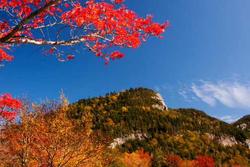
Finally, the last three days were beautiful. The skies were a deep blue, the type of blue you only see in the mountains. The trees were at their peak color, made even brighter by the beautiful sunshine. One of my final trips in the Granite State was to Echo Lake.
Located in the Franconia Notch area (just like the Basin) Echo Lake is not to far from the towns of Lincoln and North Woodstock. During the summer months Echo Lake is a popular spot for swimming, fishing, and boating. The beach closes before autumn but that doesn’t stop people from visiting the area. To the east, Bald Mountain overlooks the lake. The day I visited the area there was a beautiful reflection of the mountain in the calm lake. While walking the shoreline of the lake, I couldn’t help but notice a bright red sugar maple sticking out amongst all the other autumn colors. I decided to frame a photograph of Bald Mountain using the red sugar maple as the frame. It was beautiful.
I’ve got to tell you again I was wrong, completely wrong. I thought what I heard about New England autumns were exaggerations, made by the tourist bureaus of the various New England states to try to get us tourists to spend our dollars in their states. Well, New Hampshire received some of my Ohio money but it was worth it. If you ever have the opportunity to visit New Hampshire in the autumn take it. You won’t regret seeing a true autumn.
Lincoln, New Hampshire

Lincoln New Hampshire is literally in the middle of White Mountain National Forest


")


