Scenic Drives in the North Carolina Mountains

Appalachian Medley
This byway is near the northern end of the Pisgah National Forest - home of the Cradle of Forestry. It passes through towns with names such as Luck and Trust. Also along this route is the site of the first golf course in the southeast and the Appalachian Trail.
Route: NC 209 (near Lake Junaluska) to US 25/70 (Walnut)
Miles: 45
Time: 1.5 hours
Area Byways: Blue Ridge Parkway, French Broad Overview
Area Hikes: Craggy Gardens Trail, Richland Balsam Trail, Mount Pisgah Trail
Black Mountain Rag
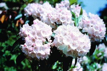
Named for the Black Mountain range that has dark evergreen foliage. In addition to the trees, there are numerous natural formations of note including Bat Cave, which is inhabited by bats and other rare mammals, Chimney Rock, and Lake Lure. This area can be spotted in various movies, including The Last of the Mohicans. Near the end of the byway, apple orchards and mountain laurel can be seen.
Route: NC 9 (Black Mountain Exit 64 off I-40) to US 64 (Edneyville)
Miles: 31
Time: 45 minutes
Area Byways: Blue Ridge Parkway, Historic Flat Rock, Drovers Road
Area Hikes: Mount Mitchell Trail, Deep Gap Trail, Craggy Gardens Trail
Blue Ridge Parkway
One of the most popular areas in the National Park Service system is the Blue Ridge Parkway. It was designated as an All-American Road by the National Scenic Byways Program. North Carolina is blessed to have 250 miles of the 469-mile route. There are many wonderful vantage points to view the fall colors.
Miles: 250 (in North Carolina)
Time: 5-7 hours
Area Byways: Appalachian Medley, Black Mountain Rag, Cherohala Skyway, Drovers Road, Forest Heritage, Little Parkway, Mission Crossing, New River Valley
Area Hikes: Green Knob Trail, Basin Creek Trail, Black Rock Nature Trail, Bluff Mountain Trail, Boone Fork, Bridge Trail, Buck Spring Trail, Craggy Gardens Trail, Deep Gap Trail, Appalachian Trail Sampler, Erwins View and Dugger's Creek Loop Trails, Tanawha Trail, Horsepasture Waterfalls Trail, Moses H. Cone Trails, Mount Jefferson Trails, Mount Mitchell Trail, Mount Pisgah Trail, New River Trail, Price Lake Loop Trail, Richland Balsam Trail, Devil's Courthouse Trail
Cherohala Skyway
This American Scenic Byway provides views of the Nantahala and Cherokee National Forests. The skyway connects western North Carolina to the Cherokee National Forest in Tennessee. It includes the Joyce Kilmer National Forest, with oaks, poplars, hemlocks, and over a hundred species of trees, along with 60 miles of hiking trails. Like the Blue Ridge Parkway, the Cherohala Parkway has low traffic speeds, enabling visitors to have time to view the forests.
Route: NC 143 (12 miles west of Robbinsville)
Miles: 20
Time: 45 minutes
Area Byways: Nantahala Byway, Blue Ridge Parkway, Indian Lakes
Area Hikes: Smokemont Nature Trail and Pioneer Farm Trail, Smokemont Loop, Joyce Kilmer NationalRecreational Trail
Drovers Road
This historical byways was once used by settlers as a route to Asheville. The path was important because it was one of only two gaps in the Blue Ridge Mountains which allowed pioneers to transverse the hills on foot, while they drove animals in front of them. The hills on the sides of the gap have stands of mature tree, including the Paulownia tree, which has been naturalized to this area following George Vanderbilt's introduction of the species in the late 1800s.
Route: US 74A (Fairview) to NC 9 (Bat Cave)
Miles: 10
Time: 20 minutes
Area Byways: Black Mountain Rag, Blue Ridge Parkway
Area Hikes: Craggy Gardens Trail
Forest Heritage
This byway provides several scenic opportunities, including access to Pisgah National Forest, which consists of over one million acres. Also along the route, Looking Glass Falls and Sliding Rock are passed, along with the Cradle of Forestry. The Cradle of Forestry promotes the study of trees and hosts several events during the fall season. Also visible is Cold Mountain, which was made famous by the book of the same name.
Route: US 276 (Brevard) to US 64 (Rosman)
Miles: 65
Time: 2 hours
Area Byways: Blue Ridge Parkway, Waterfall Byway
Area Hikes: Buck Spring Trail, Richland Balsam Trail, Mount Pisgah Trail, Horsepasture Waterfalls Trail, Devil's Courthouse Trail
French Broad Overview
The byway starts near the site of Zebulon Vance's birthplace and follows the French Broad River along trading paths used by the Indians. As Europeans began to populate the area, the paths grew wider to accommodate wagons and trains.
Route: US 25/70 (Weaverville) to NC 251 (Marshall)
Miles: 17
Time: 25 minutes
Area Byways: Appalachian Medley, Blue Ridge Parkway
Area Hikes: Craggy Gardens Trail
Historic Flat Rock
The Flat Rock community is named for a ceremonial site of flat granite used by the Cherokees. It is home to the "State Theater of North Carolina" - Flat Rock Playhouse as well as Carl Sandberg's National Memorial Site, "Connemara". Glassy Mountain's forests can be seen from a distance, as well as the McAlpin Mountain.
Route: US 25/SR 1783 (near Hendersonville) to SR 1123, 1127 and 1114 (near Flat Rock)
Miles: 7
Time: 15 minutes
Area Byways: Pacolet River, Black Mountain Rag
Area Hikes: Wildcat Rock Trail
Indian Lakes
This byway crosses the Little Tennessee River, discovered by Hernanado DeSoto, as the first tributary to the Mississippi. Along this route is Fontana Lake, the Tennessee Valley Authority's largest lake. The peaks of Joyce Kilmer Memorial Forest can be seen. The forest includes sycamore, oak, yellow-poplar, and basswood.
Route: NC 28 (Almond) to US 129 (Topton)
Miles: 60
Time: 2 hours
Area Byways: Nantahala Byway
Area Hikes: Joyce Kilmer National Recreational Trail
Little Parkway
The road winds around the face of Grandfather Mountain and connects the towns of Blowing Rock and Linville. Discover Linville Falls and Linville Gorge, one of the wildest, uninhabited areas in the eastern part of the country. This route also passes through the Pisgah National Forest. Moses H. Cone Memorial Park provides great views of the Blue Ridge Mountains.
Route: US 221 (Linville) to US 321 (Blowing Rock)
Miles: 18
Time: 45 minutes
Area Byways: Blue Ridge Parkway, Mission Crossing, New River Valley
Area Hikes: Black Rock Nature Trail, Tanawha Trail, Price Lake Loop Trail, Moses H. Cone Trails, Green Knob Trail, Erwins View and Dugger's Creek Loop Trails, Bridge Trail, Boone Fork
Mission Crossing
This route passes through North Carolina's skiing area and through the northern part of the Roan Mountains in Pisgah National Forest. It descends into the Watauga River Valley and the town of Valle Crucis.
Route: NC 194 (Elk Park) to US 321/421 (Vilas)
Miles: 17
Time: 45 minutes
Nearby Byways: Blue Ridge Parkway, Little Parkway, New River Valley
Nearby Hikes: Appalachian Trail Sampler, Bridge Trail, Black Rock Nature Trail
Nantahala Byway
This route starts near the state's largest marble deposit of such high quality it was used extensively at Arlington National Cemetery. It then passes through the towns of Andrews and Topton, and eventually parallels the Nantahala Gorge and River. Whitewater rafting, kayaking and other water sports are popular here. Further down the trek, the road passes through the Qualla Reservation, which is part of the Cherokee Nation's reservation.
Route: US 19/74/129 (Marble) to SR 1531 (Whittier)
Miles: 35
Time: 1.25 hours
Area Byways: Indian Lakes
Area Hikes: Smokemont Nature Trail and Pioneer Farm Trail, Smokemont Loop, Joyce Kilmer National Recreational Trail
New River Valley
Visitors can travel through the Stone Mountains in the New River Valley and see America's oldest and only north-flowing river. The state's only cheese factory is located in West Jefferson. Near Laurel Springs, there is another area popular for watersports.
Route: NC 194/ US 421/221 (Boone) to NC 18/88 (Laurel Springs)
Miles: 35
Time: 1+ hours
Area Byways: Blue Ridge Parkway, Little Parkway, Mission Crossing
Area Hikes: Tanawha Trail, Price Lake Loop Trail, New River Trail, Mount Jefferson Trails, Moses H. Cone Trails, Green Knob Trail, Boone Fork, Bluff Mountain Trail, Basin Creek Trail
Pacolet River
This route follows US 176 through the Tryon Thermal Belt, known for its unusual climate. This microclimate is usually free of dew and frost. Crossing the Pacolet River several times and paralleling the Saluda Grade, the steepest mainline railroad grade in the coutry, the trek ends at the Henderson County line. Also, near Saluda is Pearson's Falls Natural Heritage Site, which has 259 acres and contains hiking trails.
Route: US 176 (South Carolina line) to Tryon (Henderson County border)
Miles: 10
Time: 20 minutes
Area Byways: Black Mountain Rag, Historic Flat Rock
Area Hikes: Wildcat Rock Trail
South Mountain Scenery
This is a transitional drive into the mountains of North Carolina from the Piedmont region The the beginning of the journey, the South Mountains become visible around the town of Polkville. Then, the Appalachian Mountains come into view.
Route: NC 226 (Metcalf) to SR 1819 (Marion)
Miles: 33
Time: 45 minutes
Area Byways: Black Mountain Rag
Area Hikes: Table Rock Summit Trail, Lake James State Park Trails, Craggy Gardens Trail, Crabtree Falls Trail
Upper Yadkin Way
This journey follows the Yadkin River from the mountains into the foothills. Farmland and pastures are visible for most of the route, including the infamous Tom Dooley Grave in Ferguson. After Ferguson is Patterson, home to the Morgan School and Patterson Reserve former plantation lands. The valley surrounding the Upper Yadkin River in Caldwell is called "Happy Valley" and includes the home of Revolutionary War hero General Lenoir. This route ends at the edge of the Pisgah National Forest.
Route: NC 268 (Goshen) to US 321 (edge of Pisgah National Forest)
Miles: 22
Time: 45 minutes
Area Byways: Little Parkway
Area Hikes: Boone Fork, Tanawha Trail, Table Rock Summit Trail, Price Lake Loop Trail, Moses H. Cone Trails, Green Knob Trail
Waterfall Byway
This route allows visitors to travel through the "Land of Waterfalls," named for the 200 waterfalls in this area. It includes viewing spots for some of the waterfalls, including Toxaway Falls. After Toxaway Falls is the town of Cashiers, one of the oldest resort communities. Next is Highlands, the highest incorporated community on the East Coast. There are more falls after Cashiers that have been developed by the US Forest Service. From the Cullasaja Gorge, visitors can view the Smoky Mountains, as well as the Pisgah and Nantahala National Forests.
Route: US 64 (Rosman) to US 19/29 (Murphy)
Miles: 98
Time: 3 1/2 hours
Area Byways: Nantahala Byway
Area Hikes: Whiteside Mountain Summit Trail, Horsepasture Waterfalls Trail, Graveyard Fields WaterfallsTrail
Whitewater Way
This is a scenic way to visit Whitewater Falls, the highest waterfall east of the Rockies. , Visitors can stop at Horse Pasture River and Falls for a scenic hike and to see a series of waterfalls. Then, the byway passes through the Nantahala National Forest with almost 1.4 million acres of forest.
Route: US 64/NC 281 (Sapphire) to Whitewater Falls
Miles: 9
Time: 20 minutes
Area Byways: Waterfall Byway
Area Hikes: Horsepasture Waterfalls Trail


 in Western North Carolina")


