Hiking the Uintas: Lofty Lake Loop


Lofty Lake Loop Trail
The Lofty Lake Loop Trail is one trail that has it all. The trail passes through beautiful, shaded Uinta wilderness. Bald Mountain, Reid's Peak, and Mount Marsell stand strong in the background. Wildflowers adorn the landscape, particularly various meadow areas. Lofty Lake Loop passes multiple lakes and even more lakes are visible from a distance.
Lofty Lake Loop is a great hike for the hot summer months, as the high elevation makes for a cooler climate on an already quite shaded trail. Changing leaf colors make Lofty Lake Loop a scenic fall hike. Lofty Lake Loop can also be done in the late spring; however, the trail can be muddy or even partially covered in lingering snow.
The trail is popular and can be somewhat busy during the weekends. Many backpacker utilize the first few miles of the trail on their way to Cuberant Lake. Lofty Lake Loop can be hike clockwise or counter-clockwise. The clockwise route offers a more gradual incline.
Starting the clockwise route, the trail is initially fairly moderate. The trail heads into a grove of trees and there is a fork at just 50 feet. Take the trail to the right. At approximately 0.3 miles take the right fork towards Cuberant Lake. A gentle creek follows alongside the trail.
The trail passes through a meadow area with views of Bald Mountain and Reid's Peak. Wildflowers line the path and butterflies are common. At approximately 1 mile in the trail begins an ascent up a rocky slope.
You'll come to Kamas Lake at approximately 1.6 miles. Kamas Lake is a beautiful glacier lake against a rocky background. After Kamas Lake, the trail continues to climb eventually leading to views of Cutthroat Lake and other smaller lakes.
The trail continues to rise and then gently descends before arriving at Lofty Lake. Lofty Lake is a serene smaller lake with a ring of trees around it. You'll occasionally find people fishing at the lake.
After Lofty Lake the trail ascends to its highest point with landscape views of the forest below. Scout Lake is viewable below, named so because it is used by scouts at the nearby Camp Steiner. The trail then descends a fairly steep 520 feet. You'll hike past Scout Lake. Be sure to stay to the right at the sign to stay on the Lofty Lake Loop trail.
Picturesque Lake is just south of Scout Lake. It is the most scenic of the lakes, but mostly obscured by trees unless you veer off the trail. Picturesque Lake is the only lake that may require some bug spray. The trail then gently descends until it reaches the parking lot.
Length: 4.09 miles round-trip
Elevation Gain: 929 feet
Ending Elevation: 10,875 feet
Best time to go: Summer is best, but also can do in late spring or early fall.
Hiking time: 3 to 4 hours
How to get there: From Salt Lake City, take I-80 east. Take exit 146 for US-40 East toward Heber/Vernal. Keep right at the fork and merge onto US-40 E/189 S. Take exit 4 toward Park City/Kamas. Turn left onto UT 248. Turn left onto State Road 32. Take the 2nd right onto UT-150 East/Center Street. Follow UT-150 up the canyon approximately 31 miles. The trail head parking will be on the left side of the road (across from Pass Lake).
Other info: Dogs are allowed on this trail. There is an outhouse at the trail head.
GPS Track
Download the GPS track to your IPhone or IPad by clicking on the link below. You may also view the track on GoogleMaps.
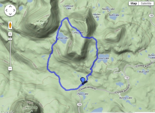
- MotionX-GPS Maps
Link to the Lofty Lake Loop GPS Track